Fortune Peak - 10.26.2008
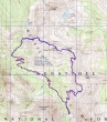
rodman's 2005 GPS route for Fortune Peak... the same route we took on 10.26.2008... 7.75 miles roundtrip, gaining 3129 feet of elevation.
|
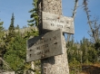
Take the Esmerelda Basin Trail #1394 for ~2 miles to this trail junction... then the County Line Trail #1226.2 for ~1 mile to the Lake Ann overlook.
|
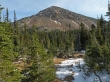
Fortune Peak from the basin leading to the Lake Ann overlook.
|
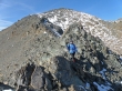
Denali Girl on the west ridge of Fortune Peak... Middle Fork Snoqualmie peaks and Dutch Miller peaks are in the distance.
|
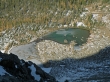
Lake Ann from the west ridge of Fortune Peak.
|
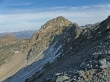
South Ingalls Peak from the west ridge of Fortune Peak.
|
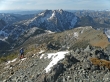
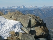
Denali Girl is on the west ridge of Fortune Peak... almost to the summit... looking across Esmerelda Pass to Hawkins Mtn.
|
Ingalls Lake, Headlight Basin, and Mt. Stuart from the Fortune Peak summit (7382').
|
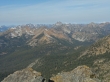
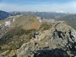
So many peaks and so little time... the foreground peaks are Scatter Peaks, The Cradle, Solomon Mtn and Harding Mtn.
|
Looking west to Four Brothers, Mt. Thomson, Chikamin Peak, Lemah Mtn, Chimney Rock, Overcoat Peak, Summit Chief Mtn and Bears Breast Mtn from Fortune Peak.
|
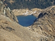
A closeup of Ingalls Lake.
|
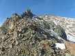
Denali Girl on the east ridge of Fortune Peak... heading towards Ingalls Pass.
|
Denali Girl on the ridge connecting Fortune Peak and Ingalls Pass... Fortune Peak in the distance.
|
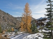
Larch trees.
|
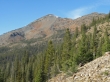
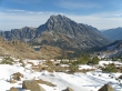
Fortune Peak... taken near the trail junction for Longs Pass... we have almost completed the loop portion of our hike.
|
