Mt. Baldy - 11.14.2008
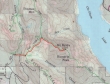
Exit 70 (Easton) off of I-90... then drive FS4818 and FS4828 to the trailhead (2400').
|
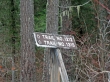
The frosty trail sign at the parking area... Trail 1315 goes us to Kachess Ridge... we took Trail 1212 up to Easton Ridge.
|
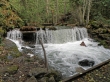
150 yards upstream from the parking area we found the bridge that crossed the fast running Silver Creek.
|
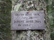
After hiking 1 mile we reached Easton Ridge at 3400'... where we took the Domerie Divide Trail 1308.2.
|
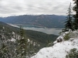
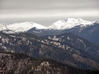
From Easton Ridge it was a steep 1.5 miles up to Point 4942... where we turned SE and soon got this view of Cle Elum Lake and the Stuart Range.
|
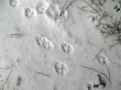
larman's photo of bobcat tracks... taken along the ridge between Point 4942 and Mt. Baldy.
|
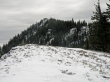
We are ~.5 miles from the Mt. Baldy summit (5107')
|
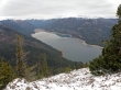
Cle Elum Lake from the Mt. Baldy summit... Mt. Daniel and Mt. Hinman are up valley... with the Stuart Range on the right.
|
A closeup of Mt. Hinman and Mt. Daniel from the Mt. Baldy summit.
|
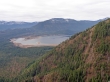
On the way back to the car we got this view of the south end of Amabilis Mtn and Kachess Lake.
|
