Bearjack East Peak - 1.15.2009
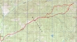
Park at 29 Pines campground... walk FS 9738 for ~3.5 miles... leave the road and head cross-country for Bearjack Ridge... 13.3 miles roundtrip, gaining 2617 feet of elevation.
|
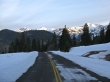
Looks like a nice day in the Teanaway as we approach 29 Pines campground.
|
We will hike FS 9738 for ~3.5 miles and then go cross-country up to Bearjack Ridge.
|
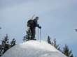
rodman near Bearjack Ridge.
|
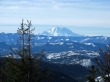
Mt. Rainier from Bearjack Ridge.
|
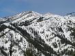
Navaho Peak and Little Navaho from Bearjack Ridge.
|
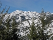
Earl Peak, the top of Mt. Stuart, and Argonaut Peak from Bearjack Ridge.
|
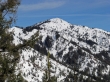
Miller Peak from Bearjack Ridge.
|
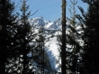
Bearjack Ridge East Peak (4800+) only has partial views of the Stuart Range... Dragontail Plateau, Witches Tower, and Little Annapurna.
|
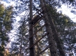
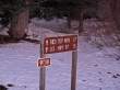
On our return we found what looked like an illegal hunting platform near FS 9738.
|
