Mount McCausland - 2.20.2009
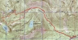
rodman's GPS route of our trip to Mt. McCausland (Point 5747)... 10.5 miles roundtrip, gaining 2740 feet of elevation.
|
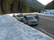
Park at the large plowed area on the north side of Hwy 2 (3150')... less than a quarter mile east of the Smith Brook road.
|
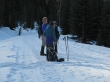
Along Smith Brook road... larman, rodman and Nanda discuss how they can get some of the government bailout money.
|
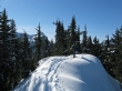
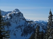
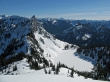
rodman on Point 5362 above Dow Lake... part of Lichtenberg Mtn is on the left.
|
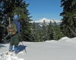
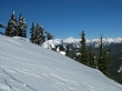
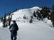
ragman checks out Glacier Peak as we continue along the ridge east of Mt. McCausland.
|
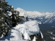
Still on the ridge leading to McCausland, we got this view of the west summit of Lichtenberg Mtn... with Hinman and part of Daniel in the distance.
|
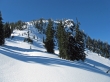
One last push remains to reach the McCausland summit.
|
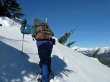
rodman kicks steps just below the McCausland summit... with Glacier Peak in the distance.
|
Only a few steps left to reach the Mt. McCausland summit (5747').
|
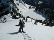
ragman on the edge... with Glacier Peak in the distance.
|
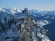
A closeup of the west summit of Lichtenberg Mtn.
|
Lake Valhalla (4830') below Lichtenberg Mtn.
|
A pano shot from the McCausland summit looking SE to SW.
|
rodman heads down for the saddle between Lichtenberg and McCausland... where we will find a very good trench leading back to Smith Brook road.
|
Looking back on Mt. McCausland from the saddle between Lichtenberg and McCausland.
|
