Iron Peak (South Ridge) - 5.8.2009
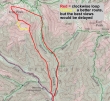
This is our general route and not a GPS track... we did the loop clockwise... ~12 miles roundtrip, gaining 3900 feet of elevation.
|
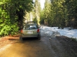
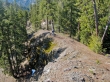
2.7 miles from the 29 Pines Campground we were blocked by both this car and the snow.
|
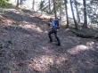
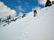
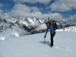
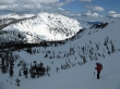
After walking the road for 1.3 miles, rdyhiker leaves the road and heads for the SSE ridge of Iron Peak.
|
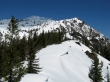
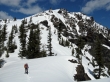
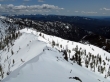
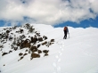
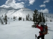
rdyhiker... with Judy's Peak in the distance.
|
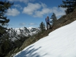
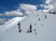
The ridge was snowfree until about 4500 feet.
|
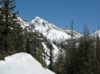
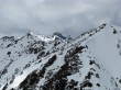
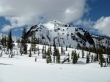
Bill's Peak
|
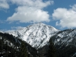
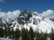
Earl Peak
|
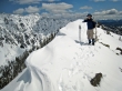
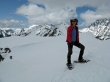
rdyhiker on the ridge... with Jolly Mtn in the distance.
|
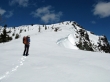
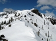
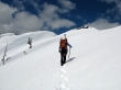
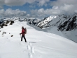
rdyhiker on one of the many bumps along the ridge.
|
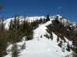
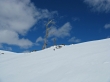
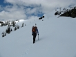
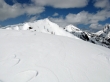
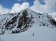
Continuous snow at ~5000 feet... still a long way to go.
|
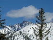
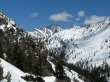
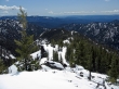
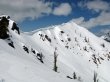
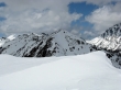
Argonaut Peak... the views are getting better.
|
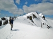
ragman approaches the top of another of the many ridge bumps.
|
Still a few ridge bumps to deal with... and still no summit.
|
Argonaut Peak... with Colchuck Peak starting to appear.
|
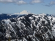
Mt. Rainier
|
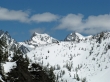
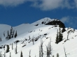
Colchuck Peak and Dragontail Peak
|
Finally... rdyhiker has passed all of the little bumps.
|
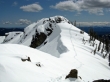
Looking back down Iron Peak's bumpy SSE ridge.
|
On steeper terrain now.
|
Dragontail Peak and Little Annapurna
|
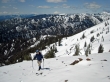
rdyhiker looks at our route up to the ridge.
|
More ridge.
|
ragman coming up towards the ridge... Mt. Rainier in the distance.
|
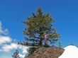
rdyhiker and interesting tree just below the ridge.
|
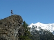
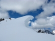
It can be lonely at the top.
|
ragman on the ridge at 6000 feet... Mary's Peak, Judy's Peak and Earl Peak on the left.
|
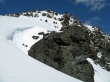
ragman going underneath a rock outcropping along the ridge.
|
More interesting ridge work to do.
|
Looking back at our route underneath the rock outcropping.
|
rdyhiker takes the lead.
|
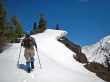
rdyhiker heading for the two 6400 foot bumps south of Iron Peak.
|
ragman near the two 6400 foot bumps... when we get around them it will be clear sailing to the summit.
|
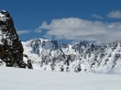
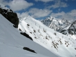
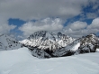
Our first good look at the Iron Peak summit... with Teanaway Peak beyond.
|
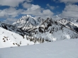
rdyhiker takes a break with most of the Stuart Range in the distance.
|
Bill's Peak in the foreground... Stuart, Sherpa, Argonaut and Colchuck in the distance.
|
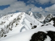
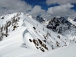
The corniced south ridge of Iron Peak.
|
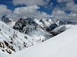
Still working our way around the two 6400 foot bumps south of Iron Peak... Mt. Stuart and Sherpa Peak to the right.
|
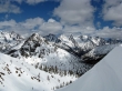
Sherpa, Bill's, Argonaut, Colchuck, Dragontail, Little Annapurna and McClellan.
|
We've made it past the two 6400 foot bumps... only 200 feet of elevation gain left to reach the summit.
|
Sherpa, Bill's, Argonaut, Colchuck, Dragontail, Little Annapurna and McClellan.
|
The corniced south ridge of Iron Peak.
|
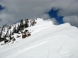
Interesting cornice on Iron Peak's south ridge.
|
Almost to the Iron Peak summit.
|
Looking back on our route around the two 6400 foot bumps.
|
rdyhiker is really close to the Iron Peak summit.
|
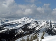
Teanaway Peak, Mt. Stuart, Sherpa Peak and Bill's Peak from the Iron Peak summit (6510').
|
Fortune Peak, Ingalls Peak and Teanaway Peak.
|
Hawkins Mtn and Esmerelda Peaks from the Iron Peak summit.
|
A closeup of the 3 summits of Ingalls Peak and Teanaway Peak.
|
rdyhiker on the Iron Peak summit.
|
rdyhiker starting down towards the 6200 foot pass between Teanaway Peak and Iron Peak.
|
A pano shot of Teanaway Peak, Bill's Peak and Devils Head in the foreground... with the Stuart Range behind.
|
Large and small... white and red.
|
Looking back on the Iron Peak summit (in the sunshine).
|
rdyhiker getting ready to drop down to Beverly Creek... Bean Peak, Mary's Peak and Judy's Peak across the valley.
|
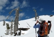
rdyhiker takes a photo of the shinning mountain.
|
Looking back on Teanaway Peak as we head for Beverly Creek.
|
Looking back on Bill's Peak as we head for Beverly Creek.
|
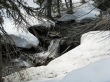
After we cross Beverly Creek we will follow it down to where it crosses Bean Creek.
|
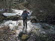
rdyhiker crossing Bean Creek... only ~3 miles of easy walking left to get back to the car.
|
