Icicle Ridge Point 7029 - 7.7.2009
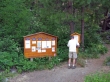
larman signs us in at the Fourth of July Creek Trailhead (2300')... drive the Icicle Creek road two miles beyond the Eightmile Campground to find the trailhead.
|
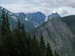
After hiking about a mile you start getting views of Cashmere Mtn across the valley.
|
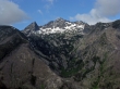
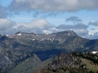
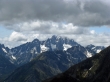
After about two miles of hiking you start getting views of the Stuart Range... Dragontail Peak in the center and Colchuck Peak on the right.
|

There were tons of Scarlet Gilia (Skyrockets) on the upper half of this trail.
|
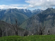
The Stuart Range as we near Icicle Ridge.
|

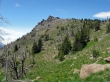
larman and BarbE on Icicle Ridge... only a quarter mile remains to reach Point 7029.
|
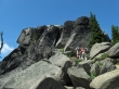
larman and BarbE near Point 7029.
|

larman and BarbE relax on Point 7029... with the Stuart Range beyond.
|
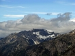
Cashmere Mtn from Point 7029.
|
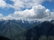
The Stuart Range from Point 7029.
|
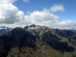
Big Lou Mtn on the left and Big Jim Mtn on the right... Lake Augusta (not visible) sits in the basin between the two.
|
Grindstone Mtn from Point 7029.
|
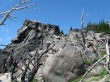
larman just below Point 7029.
|
A closeup of Sherpa Peak and Mt. Stuart.
|
Point 7029 as we head back down to the car... 11 miles roundtrip, gaining 4729 feet of elevation.
|
