Banshee Peak - 7.11.2009
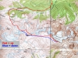
Our general route and not a GPS route... from Panhandle Gap above Summerland, Banshee Peak is Point 7400+, ~1.5 miles east of the gap... ~14 miles roundtrip, gaining ~4000 feet of elevation.
|
Drive 3 miles from Mt. Rainier's White River entrance and park (3800') just beyond the Fryingpan Creek bridge.
|
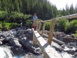
After hiking 3 miles Denali Girl crosses Fryingpan Creek on a footbridge.
|
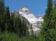
Little Tahoma just before starting up the switchbacks to Summerland.
|
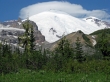
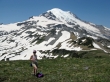
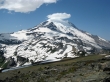
Mt. Rainier just before starting up the switchbacks to Summerland.
|
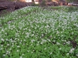
Lots of Glacier Lilies on the switchbacks up to Summerland.
|
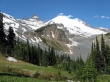
Little Tahoma and Mt. Rainier from Summerland.
|
After 4 miles of hiking, Denali Girl enters Summerland.
|
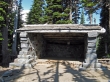
The shelter at Summerland.
|
The Innkeeper at the Summerland Shelter.
|
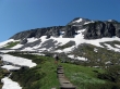
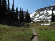
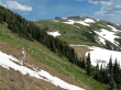
Denali Girl continues towards Panhandle Gap.
|
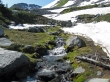
The Fryingpan Glacier keeps the water running in Summerland.
|
Waterfall in Summerland.
|
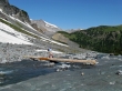
Denali Girl crossing a footbridge on the way to Panhandle Gap... Mt. Ruth in the distance on the left... west end of Goat Island Mtn in the right foreground.
|
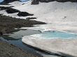
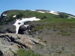
The tarn at 6300' is starting to melt.
|
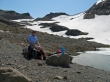
Denali Girl takes a break at the tarn... Panhandle Gap in the distance on the right.
|
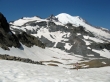
Denali Girl nearing Panhandle Gap... Little Tahoma and Mt. Rainier behind.
|
Panhandle Gap is just above the corniced ridge on the left.
|
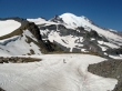
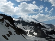
We are looking thru the gap just east of Panhandle Gap... and can see Banshee Peak above.
|
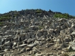
We decided to use the gap east of Panhandle Gap and will have to deal with this jumble of rocks.
|
Denali Girl crossing the boulder field... with Third Burroughs Mtn in the distance thru the gap.
|
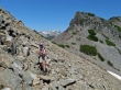
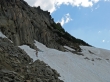
Denali Girl is off of the boulder field and working on the snow.
|
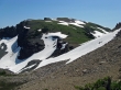
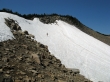
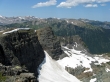
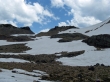
Looks like an easy walk from here to get up to the ridge.
|
Looking back on the gap (far right) we came through... Mt. Adams on the far left.
|
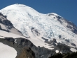
A closeup of Rainier's Emmons Glacier.
|
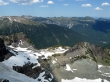
Part of the Tatoosh Range... with Mt. St. Helens in the distance on the far right.
|
A pano shot looking back towards Panhandle Gap as we head for Banshee Peak.
|
Denali Girl takes a break.
|
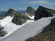
We reached the ridge (7200') and see the Central Cowlitz Chimney (7421') on the left, Point 7240+, the Main Cowlitz Chimney (7605') and Banshee Peak (Point 7431+) on the right.
|
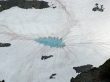
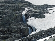
Melt on the Sarvent Glaciers.
|
|
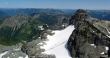
The Central Cowlitz Chimney and the Main Cowlitz Chimney from Banshee Peak.
|
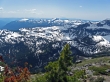
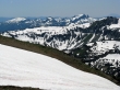
The Tatoosh Range... Mt. St. Helens in the distance... Ohanapecosh Park in the valley below.
|
Mt. Rainier with a cap... clouds are starting to form.
|
Part of the Sarvent Galciers... looking across Goat Island Mtn to Burroughs Mtn and Mt. Freemont.
|
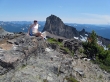
Denali Girl on the Banshee Peak summit... with the Main Cowlitz Chimney behind.
|
Tamanos Mtn on the left, part of the Sarvent Glaciers and the Central Cowlitz Chimney.
|
First Burroughs Mtn and Mt. Freemont on the left... and the line of bumps from Sunrise Point to Sunrise.
|
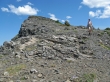
Denali Girl leaving the Banshee Peak summit.
|
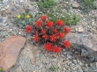
Paintbrush.
|
Denali Girl is almost at Panhandle Gap... with Banshee Peak in the distance.
|
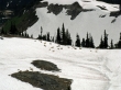
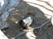
Goats hanging out on the south side of Panhandle Gap.
|
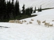
I gave back a little elevation to get a closer look at the goats.
|
Denali Girl on the north side of Panhandle Gap.
|
The clouds are starting to take control.
|
Looking back on Panhandle Gap... 5 miles left to get back to the car.
|
