Mount Ararat - 8.15.2009
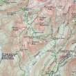
Map showing our approximate route to Mt. Ararat... 12 miles roundtrip, gaining ~4000 feet of elevation.
|
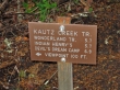
From the Nisqually entrance to Mt. Rainier Nat. Park... drive less than 2 miles and park at the first rest area on the right... cross the road and take the Kautz Creek Trail.
|
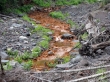
Copper colored Kautz Creek.
|
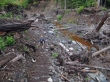
Denali Girl getting ready to cross Kautz Creek.
|
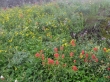
Flowers are still doing well at 5000 feet.
|
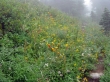
More flowers.
|
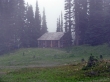
The Patrol Cabin in Indian Henry's Hunting Ground... to do Mt. Ararat it isn't necessary to go to the cabin... however, it was so foggy that we went to the cabin to get re-oriented.
|
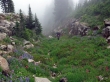
Denali Girl in the gully we used to reach the Mt. Ararat summit.
|
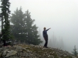
Denali Girl on the Mt. Ararat false summit... pointing to Mt. Rainier.
|
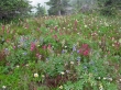
Flowers on the Mt. Ararat summit (6010').
|
