Mount Stuart - 8.19.2009 to 8.21.2009
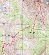
rodman's GPS route of our 3 day/2 night backpack trip and climb of Mt. Stuart... 13.7 miles roundtrip, gaining 8300 feet of elevation.
|
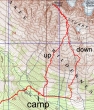
rodman's GPS route from our camp (4825') up and down Mt. Stuart... 2.5 miles up, gaining 4700' of elevation... and 2.8 miles down and back to camp.
|
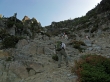
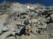
Park at the end of the N. Fork Teanaway Road... and after hiking the Ingalls Way Trail for ~2 miles we took Trail #1229 to Longs Pass.
|
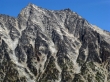
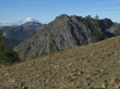
Esmeralda Peaks from the Ingalls Way/Longs Pass trail junction.
|
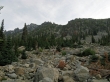
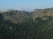
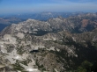
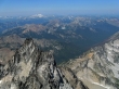
A pano shot from Longs Pass of Mt. Stuart and most of the Stuart Range... ~2.7 miles from the parking lot.
|
A closeup of the Mt. Stuart summit area from Longs Pass.
|
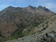
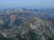
Esmeralda Peaks and Hawkins Mtn from Longs Pass.
|
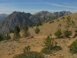
Longs Pass is in the center of the photo... taken just south of Point 6878... Bills Peak and Teanaway Peak in the distance.
|
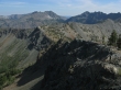
Ingalls Peak, Point 6878 and Jack Ridge... taken near Longs Pass.
|
Looking across Ingalls Pass to Fortune Peak and the three summits of Ingalls Peak... taken near Longs Pass.
|
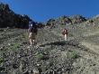
Colin, rodman and larman starting down the north side of Longs Pass.
|
Colin and larman in the 'S' curves on the north side of Longs Pass.
|

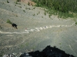
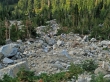
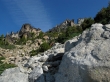
Dropping down towards Ingalls Creek... and our general route to Mt. Stuart via the Cascadian Couloir.
|
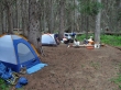
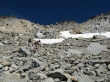
Our campsite (4825') for two nights near Ingalls Creek.
|
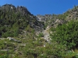
At 6:45 a.m. we started hiking up the Cascadian Couloir.
|
More of the Cascadian Couloir.
|
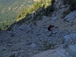
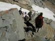
rocman and Colin in the Cascadian Couloir.
|
rodman, larman and rocman trudging up the Cascadian Couloir.
|
Looking back across Longs Pass to Mt. Rainier.
|
Still advancing in the Cascadian Couloir.
|
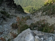
Looking down the Cascadian Couloir.
|
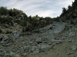
The Cascadian Couloir just keeps going and going.
|
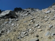
Almost near the top of the couloir.
|
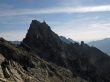
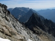
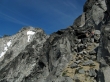
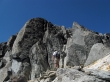
Part of the spine that runs south from Stuart's false summit.
|
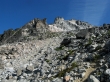
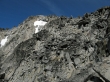
Things open up a bit after getting above the couloir... we see more of the spine that runs south from the false summit.
|
In some large boulders at the top of the couloir... Longs Pass behind.
|
Our general route to the Sherpa Peak viewpoint and on to just below the false summit.
|
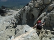
Colin coming up to the Sherpa Peak viewpoint (~8200').
|
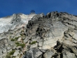
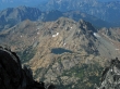
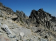
Sherpa Peak and its balanced rock from ~8200 feet.
|
The general route we will use to get up to just below the false summit.
|
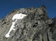
Heading for the snow field below the false summit.
|
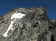
We are heading for the left side of the snow field and will stay on the rocks.
|
We are above Sherpa Peak in the foreground... Argonaut, Colchuck and Dragontail beyond.
|
rodman makes the final move to reach the point (~9000') below the false summit where we will start the traverse across to the summit.
|
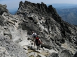
rocman, larman and Colin start the traverse over towards the 'Snoopy' snow field and Stuart summit.
|
rocman, larman and Colin getting closer to the 'Snoopy' snow field.
|
Getting really close to the 'Snoopy' snow field.
|
rocman and Colin are near the summit ridge to the right of the snow field... larman watches from below.
|
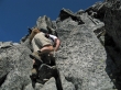
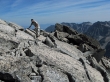
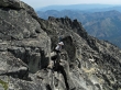
rodman climbing.
|
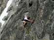
rodman climbing on the right side of the snow field... don't try this at home.
|
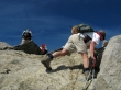
larman is on the summit ridge... reaching it from the chimney on the right.
|
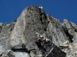
rodman in the chimney that leads to the summit ridge.
|
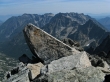
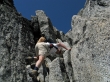
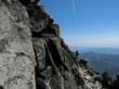
Colin on the summit slabs.
|
larman and rocman near the Stuart summit... while ragman and Colin watch.
|
Lake Ingalls and Ingalls Peak from the summit.
|

Lake Stuart below... Axis Peak in the center... Cashmere Mtn beyond.
|
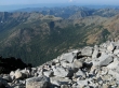
Horseshoe Lake below... with Hi-Jack Peak and Eightmile Mtn beyond.
|
Stuart's West Horn in the foreground... aligned with Scatter Peaks and Mt. Daniel.
|
Axis Peak and Cashmere Mtn.
|
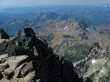
Argonaut, Colchuck, Dragontail and others from the Stuart summit.
|
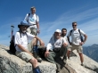
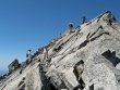
Party on the Stuart summit (9415')... ragman, rodman, rocman, Colin and larman.
|
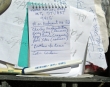
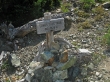
rodman added a small notebook to the summit register box.
|
Fortune Peak, Ingalls Peak and Lake Ingalls.
|
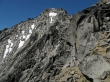
rodman in the chimney on the way back to the false summit.
|
larman watches Colin coming down the chimney.
|
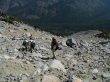
rocman scopes out the route to get back over to just below the false summit.
|
Traversing back towards the false summit.
|
Colin getting ready to step into the void???
|
rodman finishing up the traverse over to the false summit.
|
Back to the snow field below the false summit.
|
Continuing down.
|
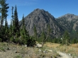
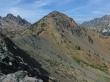
Sherpa Peak as we continue down.
|
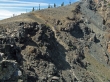
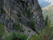
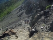
At ~7800 feet we decided to take Beckey's 'Variation No. 1' route down... heading for the meadow 3000 feet below.
|
Looking back up to the spine that runs south from the false summit.
|
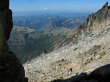
A pano shot of a lot of the Teanaway peaks as we come down the 'Variation No. 1' route.
|
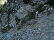
Part of the 'Variation No. 1' route... still have at least another 1000 feet of elevation loss to get back to our camp.
|
After a good nights sleep larman and Colin near Longs Pass.
|
rodman and rocman coming up to Longs Pass from the north side.
|
Mt. Rainier and Esmeralda Peaks from Longs Pass.
|
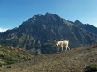
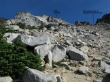
The Longs Pass guardian with Mt. Stuart behind... only 2.7 miles of downhill hiking to get back to the car.
|
