Rainy Lake - 2.8.2010

rodman's GPS route of our hike to Rainy Lake... 9.8 miles roundtrip, gaining 2894 feet of elevation.
|
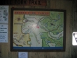
Take Exit 34 off of I-90... drive north on SE Edgewick Road for .6 miles... turn right onto FS 56 (Middle Fork Snoqualmie River Road) and drive it for 11.5 miles to the trailhead (~1000').
|
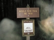
Don't expect to find the trail to Rainy Lake on the Middle Fork Valley board at the trailhead... it is an unmaintained trail.
|
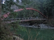
Walk 50 yards from the trailhead and cross the Middle Fork Snoqualmie River.
|
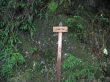
Immediately after crossing the bridge you will see this "Main Trail" sign... ignore this sign and turn right if you want to go to Rainy Lake.
|
Pink ribbons will guide you west and south along the river for a half mile... then enter the forest.
|
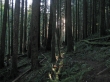
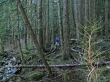
Beautiful forest.
|
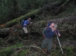
Lots of challenges on this unmaintained trail.
|

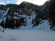
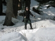
rodman and larman... in patchy snow at 3400 feet.
|
Arriving at Rainy Lake (3764').
|
ragman at Rainy Lake.
|

larman and rodman at Rainy Lake.
|
Pano shot of Rainy Lake.
|
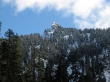
One of the many false summits of Preacher Mtn.
|
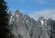
rodman's closeup of Garfield Mtn on our way back to the trailhead.
|
