Tumwater Mountain - 3.23.2010
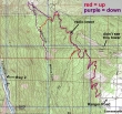
rodman's GPS route of our hike/snowshoe trip to Tumwater Mtn... 11 miles roundtrip, gaining 3557 feet of elevation.
|
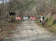
From Stevens Pass, drive Hwy 2 for 35 miles to Leavenworth... a third of a mile into Leavenworth, turn left on Ski Hill Drive and continue for .7 miles... turn left onto Ranger Road and drive to the gate (1400').
|
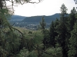
After a mile or so of road walking, we started getting some views of Leavenworth.
|
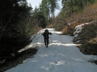
After 1.8 miles (2600'), the road had patchy snow.
|
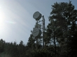
Ranger Road wraps around this radio tower (3100').
|
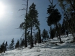
We left Ranger Road at ~3200 feet and started cross-country.
|
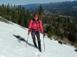
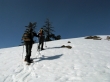
rodman and BarbE heading for the Tumwater ridge.
|
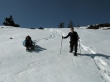
rodman and BarbE on Tumwater Ridge and heading for the subtle summit (4480+).
|
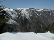
Looking across Tumwater Canyon to Icicle Ridge... Big Lou Mtn and Big Jim Mtn.
|
A closeup of Big Lou Mtn.
|
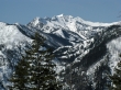
A closeup of Big Jim Mtn.
|
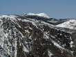
Looking towards the south end of Tumwater Mtn.
|
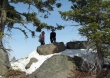
BarbE and ragman on one of the several high points on Tumwater Mtn.
|
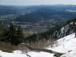
Leavenworth from Tumwater Mtn.
|
We decided to snowshoe over to the northern end of Tumwater Mtn.
|
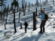
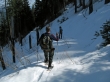
ragman and BarbE on the way to the north end of Tumwater Mtn.
|
rodman and BarbE near the northern high point (4280+).
|
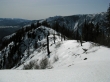
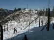
Nice view from Tumwater's northern high point.
|
BarbE tries to glissade off of the northern high point.
|
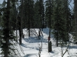
We've found the road at ~4000 feet and will follow it back to the car.
|
