Wedge Mountain - 5.25.2010
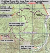
rodman's GPS route of our drive from Hwy 97 to our unsigned starting point (4450') at the end of FS7305.
|
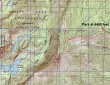
rodman's GPS route of our hike to Point 6820+ on Wedge Mtn... 4.3 miles roundtrip, gaining 2380 feet of elevation.
|
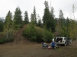
There is a large parking area at the end of FS7305... the start of the hike goes up the knoll on the left.
|

iraman, BarbE and ragman...
|
The weather looks gloomy in Leavenworth.
|
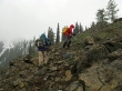
Gaining elevation on well-defined boot path.
|

Snowing now on BarbE, iraman and rodman.
|

Steady snow at 5400 feet as iraman, rodman and BarbE head for the ridge at 6200 feet.
|

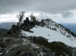
On the ridge at 6200 feet... Mission Ridge in the distance on the far right.
|
Looking towards the north end of Wedge Mtn... Icicle Ridge in the distance on the left.
|
Part of the Snow Lakes trail below Nada Lake.
|
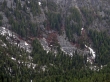
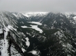
Snow Lakes on the left and Nada Lake on the right.
|

rodman and iraman with Snow Lakes in the distance.
|

Looking south along Wedge Mtn... just another bump along the way to Point 6885.
|

ragman giving advice.
|

Continuing south along Wedge Mtn... heading for Point 6885.
|

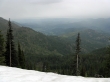
Starting to get more cloudy as we get higher.
|
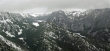
Last view of Snow Lakes before walking into the clouds.
|

Traversing along the ridge on the way to Point 6885.
|

Eating lunch near our high point for the day of 6820+ feet.
|

Too risky today to try for the summit (Point 6885).
|

ragman, BarbE and iraman... on the way down now.
|
Looking towards the north end of Wedge Mtn... Icicle Ridge in the distance on the left... and Leavenworth on the right.
|
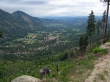
Leavenworth... seen from Mountain Home Road (FS7300).
|

Nice picnic spot... looking down on Leavenworth along the Mountain Home Road.
|
