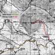
Haystack Mountain (La Sal Mountains) - 6.15.2010
|
From the La Sal Loop Road... drive the 2WD road to Geyser Pass (10,560')... the roundtrip to the summit of Haystack Mountain is ~3 miles... gaining 1,081 feet.
|
Looks like a pretty nice place for cross-country skiing.
|
Mellenthin Mountain from Geyser Pass.
|
Haystack Mountain... I'm heading for the col between Haystack and Burro Ridge.
|
Getting closer to the col between Haystack Mountain and Burro Ridge... with this view looking across Geyser Pass to Mellenthin and Tukuhnikivatz.
|
|
At the col (11,200') between Haystack Mountain and Burro Ridge.
|
200 feet of steep rubble to negotiate before reaching easier terrain.
|
The last 200 feet to the Haystack summit is still on rubble... but not as steep as the previous 200 feet.
|
Haystack Mountain summit (11,641 feet).
|
180 degree pano... looking south (left) to east to north.
|
|
The northern peaks of the La Sal Range.
|
Looking across Geyser Pass to the southern peaks of the La Sal Range.
|
On the left... looking east along the Haystack summit to Mount Tomasaki... Geyser Pass in the center... with Mellenthin, Peale and Tukuhnikivatz on the right.
|
The northern peaks of the La Sal Range from the Haystack Mountain summit.
|
Dandelions, Aspen and Haystack Mountain from our lunch spot near Geyser Pass.
|


