Seven Fingered Jack - 7.19.2010
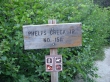
We started the hike/climb from the Phelps Creek Trailhead (3500')... located at the end of the Chiwawa River Road.
|
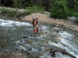
3.2 miles from the trailhead... iraman crossing Leroy Creek.
|
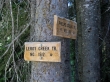
Immediately after crossing Leroy Creek, take the steep Leroy Creek Trail.
|
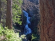
It doesn't take long to get this view of a waterfall in Leroy Creek.
|
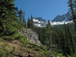
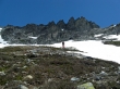
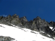
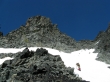
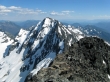
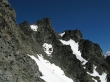
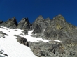
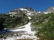
First good look at Seven Fingered Jack on the left and Mt. Maude on the right.
|
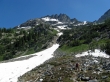
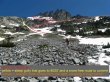
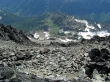
At 5.2 miles we have reached Leroy Basin (6000')... now we are looking for a good route through the brushy cliff band.
|
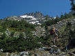
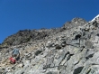
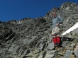
iraman has found a good route through the cliff band.
|
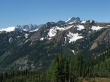
Looking back across the valley and over Phelps Ridge to Buck Mountain (I think).
|
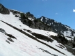
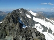
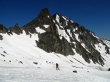
Our general route to the Seven Fingered Jack summit.
|
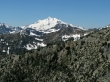
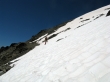
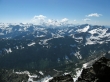
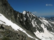
High enough now to get a nice view of Glacier Peak.
|
|
Pano shot including Buck Mtn and Glacier Peak... with Leroy Basin below.
|
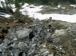
A good place to pump some water.
|
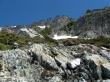
Water, rock, flowers, snow, fingers and sky.
|
iraman mulling over the possibilities.
|
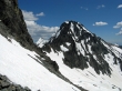
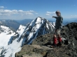
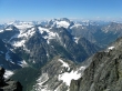
Looking over at Mt. Maude.
|
iraman and our plan.
|
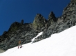
Every step higher gives a better view of Mt. Maude.
|
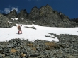
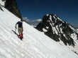
iraman ascending below the fingers.
|
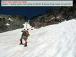
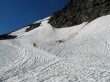
At ~8000 feet and traversing north... underneath the fingers... don't slip here.
|
Looking through the col between Seven Fingered Jack and Mt. Maude... is there a Little Maude?
|
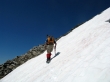
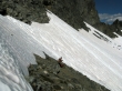
Doing an upward traverse beneath the fingers.
|
Enough of the traverse... let's head up.
|
iraman heading up... nope, that isn't the summit.
|
We are at ~8600 feet... time to turn left and get on the rock for the last 500 feet of elevation to the summit.
|
We have dropped all of our gear for the last 500 feet of elevation gain... the summit is slightly higher than the bump on the right.
|
|
A bad pano stitch... but it gives perspective... on the summit (9077') now... looking at the north face of Mt. Maude... with Entiat Meadows 3000 feet below on the left.
|
iraman points to the north face of Mt. Maude that he climbed a few years ago.
|
ragman points to a huge boulder that has a cairn on it that is visible from 500 feet below.
|
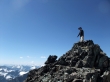
iraman on the Seven Fingered Jack summit.
|
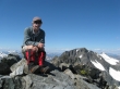
ragman was there also.
|
Glacier Peak from the summit.
|
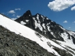
Mt. Maude... with the false summit of Seven Fingered Jack in the foreground.
|
Looking north to Mt. Fernow... the highest summit in the Entiat Mountains.
|
Bonanza Peak (I think) in the top center of the photo... the highest non-volcanic peak in Washington.
|
Looking down 3000 feet to Leroy Basin.
|
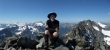
iraman on the way down from the Seven Fingered Jack summit.
|
A couple of fingers.
|
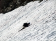
Another party of climbers ascending... with Mt. Maude in the center of the photo.
|
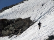
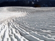
iraman testing the consistency of the snow.
|
iraman ready to start a short traverse that will get us on easier terrain.
|
ragman traversing... using an ice axe and one pole... looking for friendlier terrain.
|
Good thing I remembered which hand the ice axe was in when I slipped.
|
Beneath several of the seven fingers.
|
Much easier terrain now... we will go back down on the easiest route that we can find.
|
iraman heading over towards Mt. Maude... where a farmer has apparently been doing some plowing in the snow.
|
A closeup of the farmer's plowing.
|
Our general route up and down Seven Fingered Jack... we are still several hundred feet above Leroy Basin.
|
Back down in Leroy Basin... still 5 miles of hiking to do on weary legs.
|
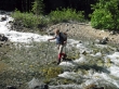
iraman dancing across Leroy Creek... on top of rocks.
|
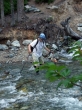
ragman crossing Leroy Creek... uh, not quite as graceful as iraman... 3.2 miles of easy hiking to get back to the car.
|
