Argonaut Peak - 8.4.2010
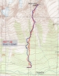
rodman's GPS route of our climb of Argonaut Peak... 4.75 miles roundtrip, gaining 4163 feet of elevation.
|
Our general route for the upper 2000 feet of elevation gain.
|
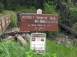
We did the trip as a three-day, two-night backpack trip... starting from the Beverly Turnpike Trailhead (3650').
|
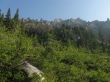
Bill Peak at the head of the valley as we hike up the Beverly Creek Trail.
|
At ~5200 feet... we took the County Line Trail for a quarter mile.
|
After hiking for a quarter-mile on the County Line Trail we reached our high point for the day at Fourth Creek Pass (5560'), where we took the Fourth Creek Trail.
|
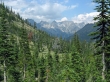
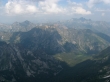
Descending from Fourth Creek Pass we got our first look at Argonaut Peak coming into view on the left... then Colchuck Peak, Dragontail Peak and Little Annapurna.
|
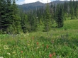
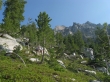
A flower-filled meadow along the Fourth Creek Trail... Bean Peak in the distance.
|
Crossing Fourth Creek.
|
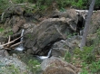
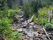
Several nice waterfalls along Fourth Creek.
|
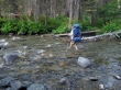
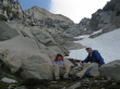
rodman crossing Ingalls Creek (~4240') in his Tevas... the creek was never higher than calf-deep.
|
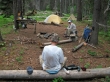
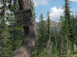
Our campsite (4330')... a short distance west of the Fourth/Ingalls Creek junction... amentities included a cooking table, nice benches and fire ring.
|
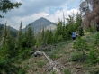
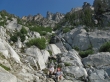
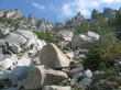
Starting at 6:30 a.m. on the second day... we used game trails when available and a little brush bashing to get our first good look at the Argonaut summit (center)... guesstimate 5600 feet elevation.
|
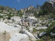
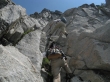
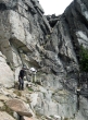
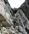
Working our way up and over towards Argonaut's primary gully.
|
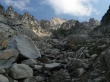
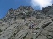
rocman and rodman resting where we entered the gully at 6500 feet.
|
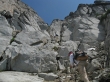
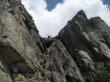
rocman and rodman heading up the primary gully.
|
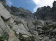
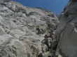
Getting higher...
|
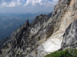
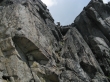
Turning a corner in the gully... and a nice view of the summit on the right.
|
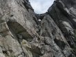
rocman is a tiny speck in the middle of the photo.
|
rocman admiring the summit... we will head for the 'V' shaped spot on the ridge above and just left of rocman's head.
|
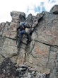
rodman ascending...
|
rodman and rocman taking a break before the final push to Argonaut's east ridge.
|
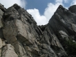
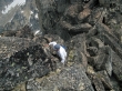
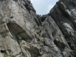
Climbing underneath the summit now.
|
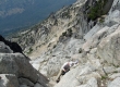
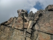
Very steep right here.
|
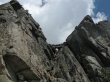
Still climbing...
|
Underneath the summit and getting closer to the east ridge.
|
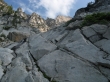
Looking back on some of the Teanaway Peaks... very hazy today.
|
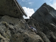
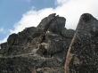
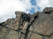
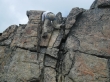
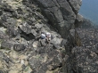
Finally we have reached the crux of the climb... the chockstone at the top of this gully.
|
rocman prepares to run the rope up the gully as ragman provides encouragement.
|
rocman making the Class 4 move to the right of the chockstone... now he will belay rodman and me up to the ridge.
|
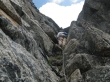
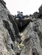
rodman on belay... underneath the chockstone.
|
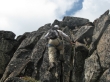
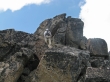
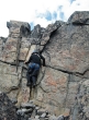
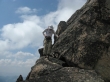
We are all on the east ridge now... rocman starts the Class 3 work towards the summit.
|
rodman coming up.
|
rocman nearing the summit.
|
Which is the best way to reach the west side of the summit block?... using the airy ledge around to the left (south) or through the middle.
|
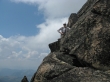
rocman on the west side of the airy ledge.
|
rodman on the airy ledge.
|
rocman finishes the last 15 feet of climbing to the summit.
|
ragman starts up the last 15 feet to the summit.
|
ragman is almost there.
|
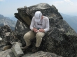
ragman topping out on Argonaut (8453').
|
Now it is rodman's turn to come up to the summit.
|
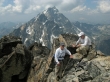
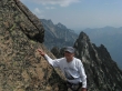
We are all on the summit now... and I'm smiling just as much as rodman and rocman.
|
rocman signs us in.
|
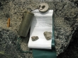
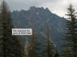
The summit register was placed in 1986.
|
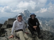
rocman and ragman on the Argonaut summit.
|
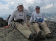
rocman and rodman on the Argonaut summit.
|
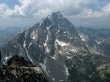
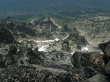
Mt. Stuart from the Argonaut summit.
|
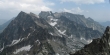
Colchuck Peak and Dragontail Peak.
|
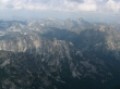
Looking across Mountaineer Ridge and Axis Peak to Hi-Jack Peak and Eightmile Mountain.
|
Looking across Axis Peak to Eightmile Mountain and Cashmere Mountain.
|
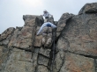
Heading down now... rodman and I used a handline to get down the 15 foot section near the summit.
|
rocman down climbing the 15 foot section near the summit.
|
I took this photo looking straight down from the airy ledge.
|
rocman on the airy ledge.
|
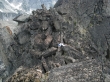
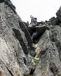
rodman working his way back to the chockstone.
|
rocman is preparing to belay rodman down the gully from the chockstone.
|
ragman on belay... crawling over the chockstone.
|
ragman hugging rock.
|
ragman on belay... breathing a lot easier now.
|
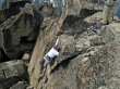
rocman preparing to rappel down from the east ridge.
|
rocman rappelling on the left side of the chockstone.
|
Easy does it on this awkward spot.
|
Breathing easy now...
|
rocman rappelling the summit gully... still lots of work left to get down to Ingalls Creek and our camp.
|
