Mount Defiance - 11.10.2010
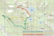
rodman's GPS route from 2006... but it is the same route we took today... ~9 miles roundtrip, gaining ~3600 feet of elevation... on the hike in we used the newer of the two abandoned trails.
|
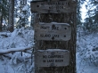
Take Exit 45 off of I-90... then drive FS 9030 for ~4 miles to the end of the road and the trailhead (2200').
|
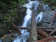
At .5 miles Mason Creek was roaring... in another eighth of a mile we found the abandoned trail.
|
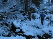
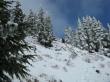
Continuous snow at ~3500 feet.
|
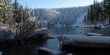
Arriving at Mason Lake (4200').
|
We continued along the north side of Mason Lake... eventually taking the Mt. Defiance Trail #1009.
|
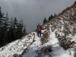
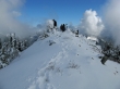
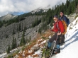
recon and iraman breaking out of the trees at ~5000 feet.
|
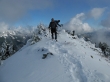
recon and iraman nearing the Mt. Defiance summit.
|
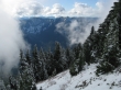
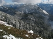
Looking across the valley to Mt. Kent and McClellan Butte.
|
recon and iraman on the Mt. Defiance summit (5584').
|
Lake Kulla Kulla 1800 feet below.
|
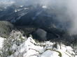
As far as mountain views were concerned, this was about as good as it got.
|
recon and iraman leaving the Mt. Defiance summit.
|
Little Mason Lake and Mason Lake below Bandera Mtn.
|
iraman and recon on the Ira Spring Trail... at least 2.5 miles of good trail will get us back to the car... West Defiance (aka Putrid Pete's Peak) on the left... and Mt. Defiance in the coulds on the right.
|
