Point 6424 above Chatter Creek Basin - 6.4.2011
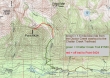
Drive the Icicle Creek Road to the Doctor Creek washout... then bike 1.5 miles to the Chatter Creek Trailhead... hike the trail to the creek crossing at ~4300'... instead of crossing the creek, contour around and into Chatter Creek Basin, always staying on the west side of the creek.
|
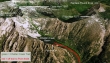
A google earth look at the area.
|
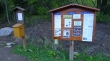
Register at the Doctor Creek washout... a 6 mile drive from the Eightmile Campground on the Icicle Creek Road.
|
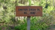
Arriving at the official Chatter Creek trailhead (~2600') after biking the 1.5 miles from the Doctor Creek washout.
|
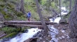
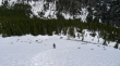
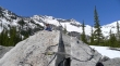
Denali Girl crossing Chatter Creek (~3120').
|

The Chatter Creek Trail wastes little time in gaining elevation... and every step higher gives a better view of Mt. Cashmere across the valley.
|
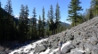
Denali Girl on the boulder field (~4400') that we used to avoid a nasty band of slide alder.
|
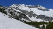
Mt. Cashmere as we contour into Chatter Creek Basin.
|
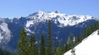
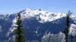
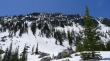
Grindstone Mountain from the south side of Chatter Creek Basin.
|
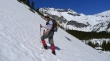
Denali Girl heading for Point 6424... on steeper terrain now... Grindstone Mtn in the distance.
|
Mt. Cashmere from Point 6424.
|
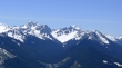
Eightmile Mountain (left) and Hi-Jack Mountain from Point 6424... and I think it is Sherpa Peak and Mt. Stuart behind Eightmile Mtn.
|
Denali Girl heading back down to Chatter Creek Basin from Point 6424.
|
Denali Girl relaxing on a boulder in Chatter Creek Basin... Point 6424 is above.
|
Denali Girl in Chatter Creek Basin with Grindstone Mountain in the distance.
|
