Hawkins Mountain - 6.17.2011
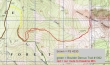
rodman's GPS route for our hike to Hawkins Mountain... 6.7 miles roundtrip... gaining 3634 feet of elevation.
|
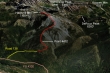
A google earth look at the Hawkins Mountain area.
|
Drive thru Roslyn and Ronald and continue on the Salmon La Sac Road for several miles... just before the road crosses the Cle Elum River, turn right on FS 4330 and head steeply uphill... drive 4330 for 5 miles and turn right onto Road 138.
|
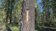
Drive Road 138 for .3 miles to a junction... stay to the right at the junction and continue driving past this sign for another .4 miles to the end of Road 138.
|
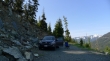
Park at the end of Road 138 (3480 feet)... a total drive of .7 miles since turning off of FS 4330.
|
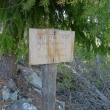
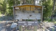
The hiker friendly sign at the end of Road 138.
|
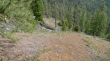
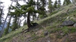
We stayed on the road/trail for ~.3 miles from where we parked... then headed uphill (3650') on a faint path.
|
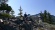
recon, Denali Girl and rodman heading uphill in the direction of Point 4472.
|
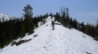
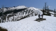
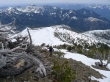
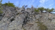
Taking a break on Point 4472.
|
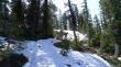
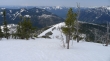
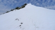
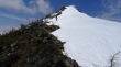
Continuing uphill from Point 4472 we found patchy snow at 4900 feet.
|
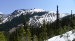
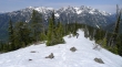
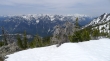
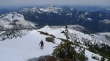
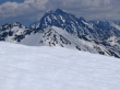
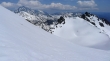
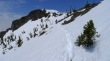
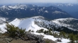
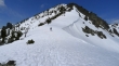
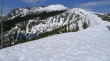
The ridge broke out of the trees at 5300 feet and gave us this view of Hawkins Mountain.
|
rodman and recon continuing up on the ridge.
|
Denali Girl coming up the ridge... Davis Peak on the left and Goat Mountain on the right.
|
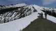
recon and rodman continue on the ridge leading towards Hawkins Mountain.
|
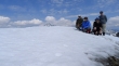
rodman, Denali Girl and recon on the ridge leading to Hawkins Mountain.
|
Denali Girl on steeper terrain now... with our access ridge below.
|
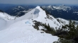
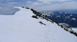
Only 400 feet of elevation remains to get us up to the false summit... the east summit (a.k.a. The Thimble) is on the right ridge line.
|
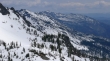
Looking west across Davis Peak and Goat Mountain to some of the Snoqualmie Pass and Dutch Miller Peaks.
|
Looking SE across Esmeralda Peaks and Teanaway Peak to Earl Peak on the horizon... the bump on the right is Iron Peak.
|
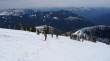
Denali Girl ascending towards the false summit... Jolly Mountain is left center in the distance.
|
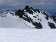
Hawkins east summit (Thimble) as we continue for the false summit.
|
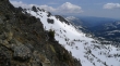
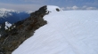
Hawkin's false summit... we will avoid the cornices on the east-facing slope.
|
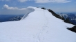
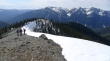
Denali Girl is almost on the false summit.
|
From the false summit, rodman and recon look like ants on the true summit... but really aren't that far away.
|
Looking back on the false summit as I work my way over to the summit... serious cornice activity.
|
Looking across Ingalls Peak (left) and Fortune Peak (center) to The Stuart Range.
|
Hawkins east summit in the foreground... west summit of Three Brothers, Navaho Peak and Bill Peak are to the left in the distance.
|
recon and rodman relaxing on the Hawkins Mountain summit (7160+).
|
Looking at the cornices from the true summit leading over to the false summit.
|
Almost on the summit now.
|
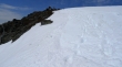
Another step here would be a bad idea.
|
The Stuart Range from the Hawkins summit... Hi-Jack Mtn, Eightmile Mtn and Cashmere Mtn are on the left.
|
A pano shot from the Hawkins summit... Mt. Daniel on the far left to The Stuart Range on the right.
|
Group shot on Hawkins Mountain... recon, Denali Girl, ragman and rodman.
|
rodman and recon lead the way off of the summit... we decided to avoid the corniced ridge.
|
Denali Girl descending from the Hawkins summit.
|
Denali Girl coming down... below the false summit now.
|
Still heading down... we will return to the car via the ridge on the right.
|
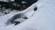
Denali Girl descending on rock.
|
Ever downward.
|
Denali Girl, recon and rodman descending.
|
rodman, recon and Denali Girl discussing the price of Gold... Davis Peak and Goat Mountain in the distance.
|
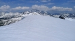
Last look at Hawkins Mountain before we reenter the trees.
|
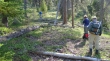
Working our way back down to the trail.
|
Still 3 or 4 hundred feet above the trail... then a short hike back to the car.
|
