Goat Island Mountain - 7.6.2011
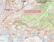
This is not a GPS track, but does show our general route to the summit of Goat Island Mountain... 13.5 miles roundtrip, gaining 4000 feet of elevation.
|
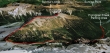
A google earth look at the Goat Island Mountain area.
|
Use the White River entrance to Mt. Rainier National Park... drive ~3 miles to the parking area just beyond the Fryingpan Creek bridge (3800').
|
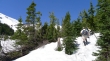
In less than a mile of hiking you can look up towards the Sarvant Glacier area.
|
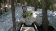
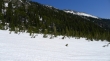
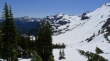
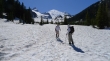
Continuous snow at ~4100 feet of elevation... after less than one mile of hiking.
|
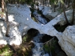
A stubborn snow bridge.
|
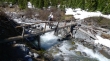
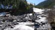
At 3.2 miles there is a footbridge (not shown in photo) that crosses Fryingpan Creek.
|
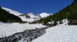
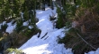
We chose to stay on the north side of Fryingpan Creek and head upstream.
|
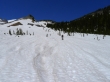
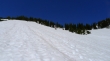
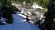
At times the terrain pushed us above the creek... this would be a lousy place to be if the snow wasn't covering the brush.
|
A pano shot of Meany Crest on the left to Little Tahoma and Mt. Rainier on the right.
|
A closeup of Little Tahoma (left) and K Spire as we continue towards the SW end of Goat Island Mountain.
|
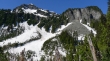
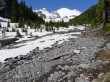
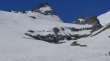
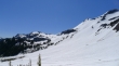
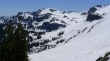
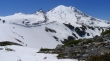
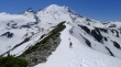
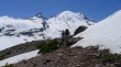
Looking up at Goat Island Mountain from Fryingpan basin... can't see the summit though.
|
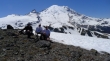
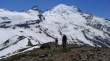
recon and larman heading for the low point at the SW end of Goat Island Mountain.
|
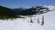
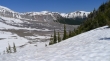
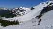
Looking back towards Summerland, Panhandle Gap (corniced ridge in the center of photo) and Meany Crest on the right.
|
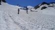
Looking back towards Tamanos Mountain (center)... Panhandle Gap on the far right.
|
recon and larman continuing towards the 6400 foot col at the SW end of Goat Island Mtn.
|
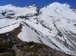
Tamanos Mtn and Panhandle Gap from the 6400 foot col.
|
A closeup of Banshee Peak (center) and Panhandle Gap on the right.
|
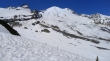
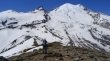
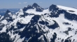
From the 6400 foot col... Little Tahoma, Rainier... with Steamboat Prow and Mt. Ruth on the right.
|
Second and Third Burroughs from the 6400 foot col.
|
A closeup of Little Tahoma and K Spire from the col.
|
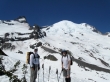
recon and ragman at the 6400 foot col.
|
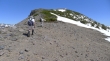
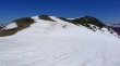
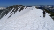
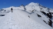
recon and larman heading NE along the Goat Island Mountain ridge.
|
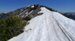
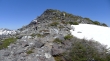
We can see several bumps along the ridge... but none of them are the summit.
|
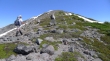
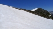
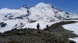
recon and larman on the ridge (~6800')... pretty good views here.
|
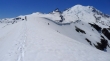
larman and recon continue towards an unmarked bump on the ridge.
|
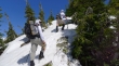
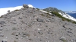
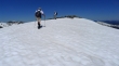
larman ascending... will we ever get there?
|
Still heading up.
|
recon checking his altimeter.
|
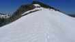
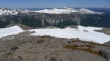
larman ascending... now we can see Points 7218, 7240+ and 7186 in the distance... can't reach the summit until we get past them.
|
recon (little speck on left) heading for Point 7218 and Point 7240+.
|
recond heading for Point 7240+.
|
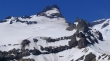
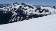
A closeup of the Cowlitz Chimneys, Banshee Peak and Sarvant Glacier.
|
We can see the summit (left)... recon heading for Point 7186 (center).
|
larman at Point 7186.
|
Looking across Panhandle Gap to Mt. Adams in the distance on the right... Cowlitz Chimneys and Banshee Peak on the left.
|
recon leads the way to the Goat Island Mountain summit.
|
The corniced ridge leading from Point 7240+ to Point 7186.
|
Almost on the summit.
|
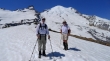
larman and recon on the Goat Island Mountain summit (7288').
|
Looking over at Sunrise from the summit.
|
Group shot on the summit... ragman, recon and larman.
|
larman and recon at Point 7186 as we start the long ridge walk back to the 6400 foot col.
|
Nearing Point 7240+.
|
Nearing Point 7218.
|
Hiking underneath Point 7218.
|
Only a couple of bumps left to get back to the 6400 foot col.
|
recon at the col...
|
We decided to return to the footbridge by crossing the snow-covered Fryingpan Creek and then staying on the south side of the creek.
|
Almost back to the footbridge.
|
The footbridge that crosses Fryingpan Creek.
|
recon coming down to the footbridge.
|
larman crossing the footbridge.
|
recon uses a log to get across the portion of Fryingpan Creek that isn't handled by the footbridge.
|
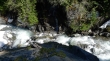
Fryingpan Creek is raging... almost back to the car... and the end of a long day.
|
