Big Lou Mountain and Big Jim Mountain - 7.23.2011
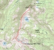
The red line shows our approximate off-trail route to Big Lou Mountain and Big Jim Mountain. From our base camp (6400') we hiked the Icicle Creek Trail to 7320 feet... then off-trail along the ridge to Big Lou... back to 7320' and off-trail along the ridge to Big Jim... back to 7320' and back down to base camp... ~7 miles roundtrip, gaining ~3000 feet of elevation.
|
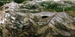
A google earth look at the area.
|
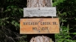
Drive US 2 to the Wenatchee River bridge opposite Tumwater Campground... turn onto the Hatchery Creek Road (FS 7905) and drive 2.4 miles to the trailhead (~2800').
|
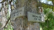
After hiking 3 miles (~5320'), stay on the Hatchery Creek Trail where it junctions with The Badlands Trail.
|
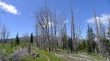
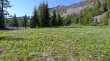
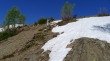
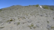
At ~4 miles enter a silver forest.
|
The silver forest was full of wild flowers.
|

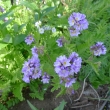
Lupine
|
Jacob's Ladder
|
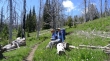
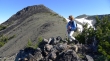
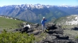
BarbE and Denali Girl taking a break in the silver forest.
|
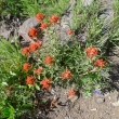
Paintbrush
|
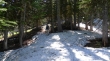
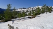
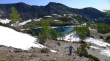
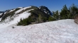
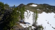
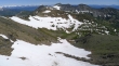
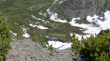
We found patchy snow at ~6200 feet.
|
After ~6.5 miles of hiking we took the Icicle Ridge Trail.
|
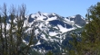
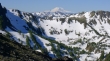
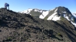
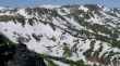
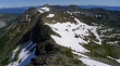
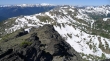
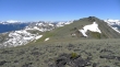
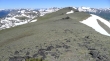
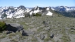
Big Lou Mountain (left center) and Point 7760+ on the right.
|
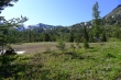
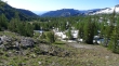
We continued ~1 mile on the Icicle Ridge Trail and found a nice camp site in Cabin Creek Basin (~6400').
|
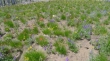
Cabin Creek Basin was filled with Glacier Lilies and Western Anemones.
|
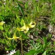
Glacier Lilies.
|
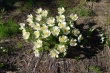
Western Anemone.
|
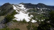
Lake Augusta sits at the base of the ridge above... Point 7571 is left center.
|
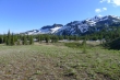
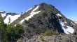
From Cabin Creek Basin... Big Lou Mountain on the right.
|
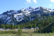
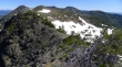
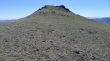
A closeup of Big Lou Mountain from Cabin Creek Basin.
|
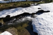
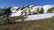
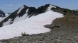
Still some snow in Cabin Creek Basin.
|
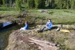
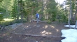
BarbE and Denali Girl preparing dinner near our campsite.
|
The sound of Cabin Creek made it very easy to get a good night's sleep.
|
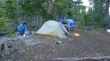
Preparing breakfast the next morning... Denali Girl and I were testing our 2.5 pound Big Agnes tent.
|
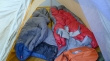
The Big Agnes tent was pretty cozy... however, did I mention that it only weighs 2.5 pounds.
|
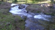
Water flowing out of Lake Augusta.
|
Looking back at Cabin Creek Basin as we head up to Lake Augusta.
|
Denali Girl approaching Lake Augusta... Big Lou Mountain above on the right.
|
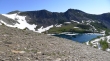
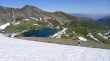
A pano shot of Lake Augusta (6854')... Point 7571 on the left.
|
On the south side of Lake Augusta and heading for the ridge above.
|
Denali Girl heading for the ridge on the west side of Lake Augusta.
|
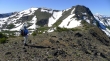
BarbE is almost on the ridge.
|
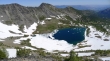
Lake Augusta from the ridge just south of Point 7571... Big Jim Mountain in the distance on the left.
|
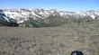
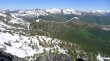
Looking south and west from the ridge above Lake Augusta.
|
A closeup of Mt. Rainier from the ridge above Lake Augusta.
|
BarbE on the ridge above Lake Augusta... Point 7571 on the left... Big Jim Mountain in the distance on the right.
|
Our journey to Big Lou will take us over Point 7443 (foreground)... then down and up to Point 7760+ (right)... and finally, down and up to Big Lou (in the distance on the left).
|
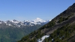
Looking north to Glacier Peak.
|
Denali Girl and BarbE on Point 7443... Point 7760+ on the right... Big Lou (center).
|
From Point 7443 we are looking back at Lake Augusta, Point 7571 (left) and Big Jim Mountain.
|
BarbE contemplates our route to Big Lou Mountain.
|
Denali Girl working her way over to Point 7760+... Point 7443 in the foreground.
|
Looking across Point 7313 and Frigid Mountain to Mt. Daniel... Grindstone Mountain on the right behind Frigid Mountain.
|
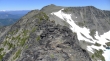
Working our way along the ridge towards Point 7760+.
|
Looking back along the ridge to Point 7443, Point 7571 and Big Jim Mountain.
|
BarbE on the ridge heading for Point 7760+.
|
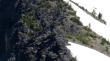
Sometimes it was easier to be on the snow.
|
BarbE ascending towards Point 7760+.
|
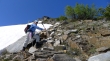
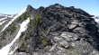
BarbE checks out the cliffy area ahead.
|
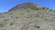
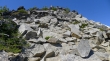
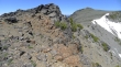
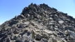
Some Class 2 work just below the top of Point 7760+.
|
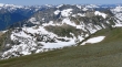
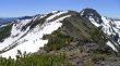
Looking at the ridge that goes from Point 7760+ to Point 7443... then to Point 7571... and on over to Big Jim Mountain.
|
Denali Girl decided to relax and wait for us to come back from Big Lou.
|
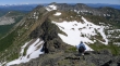
ragman on Point 7760+... Cashmere Mountain and The Stuart Range are on the left.
|
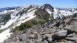
The ridge leading from Point 7760+ over to Big Jim Mountain.
|
Looking west across Point 7313, Frigid Mountain and Grindstone Mountain to Mt. Daniel.
|
BarbE on Point 7760+.
|
A closeup of Cashmere Mountain (foreground) and part of the Stuart Range... Aasgard Pass in the distance on the left with a peek at the snow-covered Little Annapurna.
|
Carter Lake in the center of the photo.
|
BarbE heading for the Big Lou summit.
|
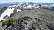
Big Jim Mountain (top center) as we continue for the Big Lou summit.
|
Looking back at Point 7760+ as we head for the Big Lou summit... Mt. Daniel on the far left... Big Chiwaukum on the far right.
|
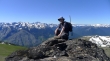
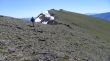
BarbE is almost on the Big Lou summit (7763').
|

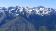
Cashmere Mountain and the Stuart Range from Big Lou Mountain.
|
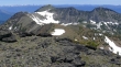
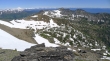
Point 7760+ from the Big Lou summit.
|
A closeup of Lake Ida from the Big Lou summit... Grindstone Mountain is the huge mountain in the center of the photo.
|
Looking over to Lake Augusta and Big Jim Mountain from Big Lou.
|
A closeup of Lake Augusta and Big Jim Mountain from Big Lou.
|
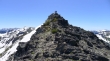
Old friends... sitting on mountain tops... like bookends.
|
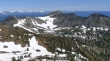
We've come back from Big Lou to Point 7760+ and BarbE is heading down.
|
BarbE and Denali Girl heading for Point 7571... our route to Big Lou Mountain is behind them.
|
Point 7571... we will go up and over it on our way to Big Jim Mountain.
|
Denali Girl ascending Point 7571.
|
Denali Girl ascending Point 7571 above Lake Augusta.
|
BarbE on top of Point 7571.
|
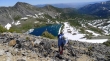
Lake Augusta from Point 7571.
|
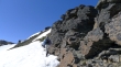
Denali Girl and BarbE are going to stay on Point 7571 until I find a good route through a cliffy area along the ridge.
|
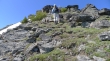
I've found a good route (Class 2)... but Denali Girl and BarbE aren't going to follow me.
|
Still some Class 2 work to do before I can get to easier terrain... Big Jim in the distance.
|
One last bump to get over... Big Jim in the distance.
|
A casual stroll from here to the Big Jim Mountain summit.
|
Looking at the ridge that runs from Big Lou (far left) to where I'm standing on the Big Jim Mountain summit (7763').
|
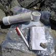
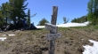
'Middle E' said that he wasn't able to open the Big Jim summit register when he visited on July 2... of course it opened like butter for me... so I signed him in.
|
Looking south from the Big Jim summit.
|
Looking down to one of the two Big Jim Mountain Lakes.
|
Heading back from Big Jim towards the cliffy area that leads over to Point 7571 (left).
|
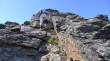
One last jumble of rocks to get past... then I'll be back to Point 7571.
|
BarbE heading back down to Lake Augusta.
|
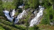
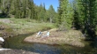
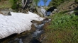
A beautiful waterfall below Lake Augusta... just a half-mile left to get back to our base camp.
|
After a good night's sleep Denali Girl packs up for the 7.5 mile hike back to the trailhead... stats... trailhead to base camp, 7.5 miles gaining ~4000 feet of elevation... day hike to Big Lou and Big Jim, ~7 miles roundtrip gaining ~3000 feet of elevation... base camp to trailhead, 7.5 miles gaining ~450 feet of elevation.
|
