Fay Peak and Mount Pleasant - 7.28.2011
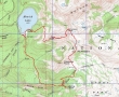
rodman's GPS route of our trip to Fay Peak and Mt. Pleasant in Mt. Rainier National Park... 6.8 miles roundtrip, gaining 2616 feet of elevation.
|
A google earth look at this area.
|
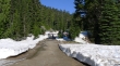
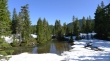
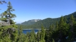
I'm standing in the Mowich Lake Campground looking out to the parking lot... most of the campground is still under snow.
|
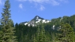
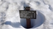
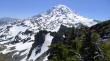
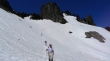
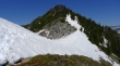
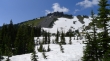
Fay Peak from the parking lot (4929').
|
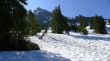
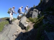
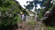
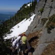
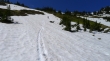
From the campground we will follow the fence posts on the right.
|
Heading for the Patrol Cabin.
|
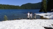
larman, BarbE, rodman and Mowich Lake.
|
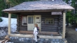
The Patrol Cabin is getting a new porch... at this cabin follow the sign for an "unmaintained trail".
|
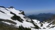
Looking back at Mowich Lake and Tolmie Mountain as we head toward Knapsack Pass.
|
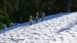
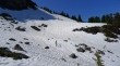
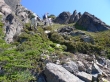
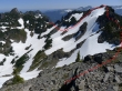
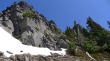
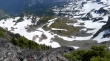
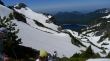
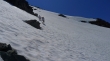
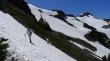
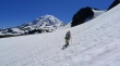
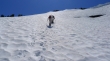
Still plenty of snow.
|
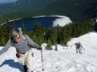
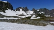
Fay Peak... several hundred feet above the lake now... heading for the ridge on the right.
|
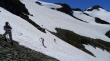
rodman and BarbE heading for the west ridge of Fay Peak.
|
rodman, ragman and larman nearing the west ridge (~5800') of Fay Peak... Mowich Lake below.
|
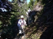
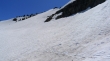
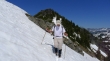
Putting on our spikes near 6000 feet.
|
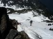
Nearing the ridge.
|
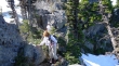
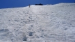
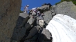
Moving along the ridge in a moat.
|
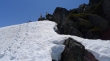
On the ridge now.
|
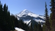
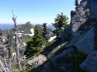
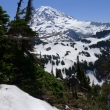
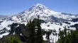
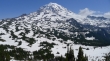
Nice view of Rainier from Fay's west ridge.
|
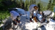
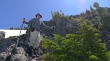
rodman conducts a map class.
|
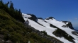
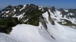
Fay Peak and the ridge leading to it.
|
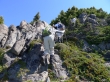
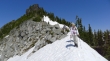
When you reach the summit block... go to the right for a short distance and look for a path heading up on the south side of Fay Peak.
|
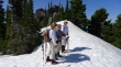
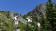
rodman, larman and BarbE heading up.
|
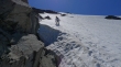
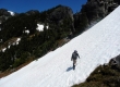
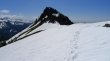
Still ascending on obvious path.
|
Nearing the top of Fay Peak.
|
Near the summit we follow the path over to the north side of the peak... First Mother Mountain on the left.
|
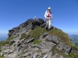
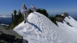
BarbE, rodman and larman on the Fay Peak summit (6492').
|
Group shot on the Fay Peak summit... larman, ragman, rodman and BarbE.
|
A look at the ridge leading over to Knapsack Pass (left).
|
Our approximate route from Fay Peak to Knapsack Pass.
|
Leaving the Fay Peak summit.
|
On the south side of the ridge connecting Fay Peak and Knapsack Pass.
|
We will head for the 'V' in the center of the photo.
|
Nearing the ridge connecting Fay Peak and Knapsack Pass... Fay Peak in the distance.
|
rodman coming up to the ridge.
|
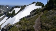
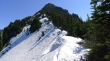
Back on the ridge... good path along the ridge top... except for the part under the snow... Knapsack Pass on the far left.
|
Working our way over toward Knapsack Pass.
|
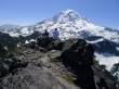
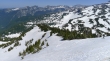
Mount Rainier from the ridge... Mt. Pleasant is between the trees in the center of the photo.
|
BarbE and ragman on the ridge heading toward Knapsack Pass.
|
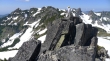
Small steps here... Fay Peak on the right.
|
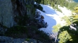
Looking down on the shelf that we will use to get from Knapsack Pass to Mount Pleasant.
|
Mt. Rainier from the ridge... we are getting ready to drop off of the ridge because we don't want to traverse on the snow.
|
Dropping off of the ridge... between two snow fields... Fay Peak on the left... Mowich Lake below.
|
rodman descending from the ridge.
|
BarbE descending from the ridge.
|
Still descending.
|
After giving back the necessary elevation we will traverse over to Knapsack Pass... Fay Peak on the right.
|
BarbE is off of the first snow field and heading for Knapsack Pass... Fay Peak in the distance.
|
ragman traversing the second snow field and heading toward Knapsack Pass.
|
BarbE, larman and rodman crossing the second snow field... Fay Peak on the right.
|
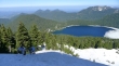
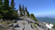
Looking at Mowich Lake from near Knapsack Pass (6200').
|
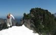
From Knapsack Pass you only get a partial view of Mount Rainier.
|
Leaving Knapsack Pass... heading down toward the shelf on the east side of the pass.
|
On the east side of Knapsack Pass (far left) and heading toward Mt. Pleasant... First Mother Mountain on the far right.
|
Mt. Pleasant is just around the corner.
|
Looking back at Knapsack Pass (far left) and First, Second and Third Mother Mountain.
|
The Mount Pleasant summit is at the top of the photo.
|
Taking a direct route toward the Mt. Pleasant summit.
|
Still ascending toward the Mt. Pleasant summit.
|
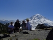
larman and BarbE on the Mt. Pleasant summit (6454').
|
ragman nearing the Mt. Pleasant summit.
|
Fay Peak (far left) and Mother Mountain (right) from Mt. Pleasant.
|
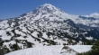
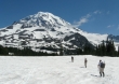
Mt. Rainier from Mt. Pleasant... Spray Park below is still covered by snow.
|
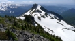
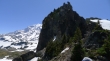
Hessong Rock from Mt. Pleasant.
|
I scrambled over to the true summit and got this shot of larman and Mt. Rainier.
|
Looking over to Tyee Peak, Crescent Mtn, the Sluiskins, Old Desolate and Burroughs Mtn.
|
|
Pano shot from Fay Peak (left) to Mother Mountain (right).
|
Pano shot of Mt. Rainier from Mt. Pleasant.
|
BarbE points out Fay Peak from the Mt. Pleasant summit.
|
We've left the Mt. Pleasant summit and heading for the saddle between Pleasant and Hessong Rock.
|
Heading for the saddle between Mt. Pleasant (behind us) and Hessong Rock.
|
Still heading for the saddle... Mt. Pleasant above.
|
Still heading for the saddle.
|
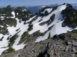
Almost to the saddle... looking at Hessong Rock.
|
Mt. Rainier from the saddle between Mt. Pleasant and Hessong Rock.
|
Coming down from the saddle between Hessong Rock and Mt. Pleasant.
|
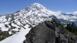
In Spray Park... looking for the Wonderland Trail that will take us back to Mowich Lake.
|
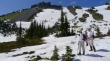
BarbE, rodman and larman in Spray Park.
|
Hessong Rock from Spray Park... getting ready to leave Spray Park.
|
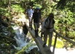
After hiking .8 miles from Spray Park we decided to take the .1 mile hike over to check out Spray Falls.
|
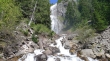
Spray Falls did not disappoint... we have a 2 mile hike to get us back to Mowich Lake.
|
