Skyscraper Mountain and Burroughs Mountain - 8.3.2011
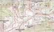
rodman's GPS route of our trip to the Mt. Fremont Lookout, Skyscraper Mountain and Burroughs Mountain... 13 miles roundtrip, gaining 3903 feet of elevation.
|
A google earth look at this area.
|
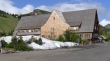
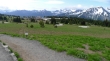
From the White River Entrance to Mount Rainier National Park, drive to Sunrise (6400').
|
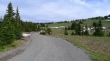
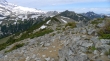
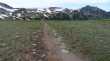
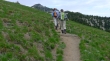
From the parking area at Sunrise, take the short hike up to the Sourdough Ridge Trail.
|
There are a lot of options out of Sunrise... when we get to the ridge we will turn west and head for the Mt. Fremont Trail.
|
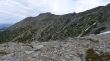
Looking back at Sunrise from the ridge.
|
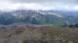
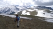
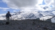
BarbE and rodman on the ridge above Sunrise... Mt. Fremont is in the distance on the right.
|
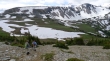
Mt. Rainier from the ridge above Sunrise... we are hiking toward Frozen Lake.
|
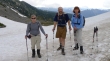
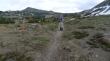
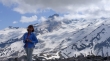
rodman and BarbE with nwhiker 'Bryan K' who we met near Frozen Lake.
|
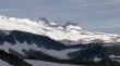
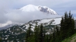
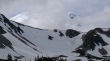
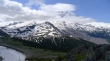
A closeup of Observation Rock (left) and Echo Rock.
|
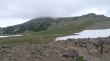
We will start hiking on the Mt. Fremont Trail... the Lookout is 1.3 miles away.
|
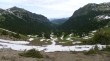
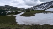
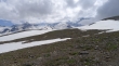
Looking across the three Burroughs to Mount Rainier from the Mt. Fremont Trail... note how snow is still covering the trail on the north side of First Burroughs Mtn (left).
|
rodman and BarbE on the Mt. Fremont Trail... In the distance, Skyscraper Mtn is the highest one on the right.
|
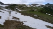
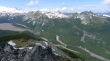
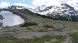
Looking across Berkeley Park and the Second and Third Burroughs to Mt. Rainier.
|
We've turned the corner just below Point 7317 on the Mt. Fremont Trail... and have a clear look at the Mt. Fremont Lookout at the end of the ridge.
|
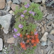
Jacobs Ladder and Paintbrush along the Mt. Fremont Trail.
|
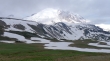
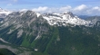
Mount Rainier from the Mt. Fremont Lookout... the Northern Loop Trail drops from Berkeley Park into the green valley below... Skyscraper Mtn in the right foreground... Point 6917 in the left foreground.
|
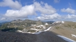
Grand Park from the Mt. Fremont Lookout.
|
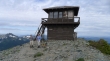
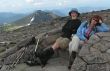
rodman and BarbE at the Mt. Fremont Lookout (7181').
|
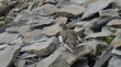
A ptarmigan near the Mt. Fremont Lookout.
|
Leaving the lookout we will backtrack about a half mile and take the ridge (just below Point 7317) in the right foreground and head toward Point 6917.
|
rodman and BarbE heading toward Point 6917... the Mt. Fremont Trail and Point 7317 is behind.
|
We are heading for the saddle between Point 6917 (foreground) and Point 7317.
|
Looking at the Mt. Fremont Lookout (far left) from the saddle between Point 7317 and Point 6917.
|
rodman and BarbE dropping into Berkeley Park.
|
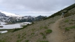
Looking across the saddle between Second and Third Burroughs Mountain to Mt. Rainier from Berkeley Park.
|
We have found the Northern Loop Trail, but will need to continue south for a short distance to find the Wonderland Trail... Skyscraper Mtn on the right.
|
On the Wonderland Trail in Berkeley Park... Point 7317 is the big bump on the left.
|
On the Wonderland Trail heading for Skyscraper Pass... Skyscraper Mtn on left and Point 6917 on the right.
|
Skyscraper Pass is in the 'V' on the right... Skyscraper Mtn on the far right.
|
From Berkeley Park... looking back at Point 7317 (left) and First Burroughs Mtn (right).
|
BarbE and rodman on the Wonderland Trail... Skyscraper Mtn in the distance.
|
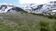
Nearing Skyscraper Pass... looking back across Berkeley Park to Mt. Fremont (left)... First Burroughs (center) and Second Burroughs (right).
|
BarbE and rodman on the Wonderland Trail heading for Skyscraper Pass... Skyscraper Mtn in the distance.
|
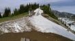
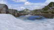
Can't slip at this snow crossing at Skyscraper Pass (6700').
|
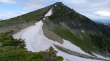
Skyscraper Mtn from Skyscraper Pass.
|
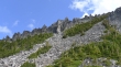
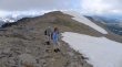
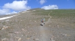
rodman and BarbE heading up on Skyscraper Mtn.
|
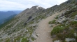
BarbE and rodman nearing the Skyscraper summit area... good path all the way to the top.
|
BarbE and rodman on the Skyscraper Mtn summit (7078')... Mt. Fremont (left) and First Burroughs (right).
|
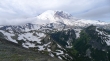
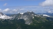
Looking across Third Burroughs Mtn to Mt. Rainier.
|
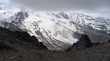
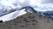
Old Desolate (center)... with Crescent Mtn (flat top) and the Sluiskins on the right.
|
A closeup of Crescent Mtn and the Sluiskins.
|
A closeup of Old Desolate.
|

A closeup looking across Third Burroughs Mtn (left foreground) to Mt. Rainier.
|
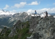
rodman got this shot of BarbE and ragman on the Skyscraper summit.
|
Group shot from the summit... BarbE, rodman and ragman.
|
Pano shot from the Skyscraper summit... Mt. Fremont (left)... First and Second Burroughs (right)... Skyscraper Pass (right foreground).
|
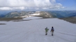
rodman and BarbE leaving the Skyscraper summit.
|
BarbE descending from the Skyscraper summit.
|
We will head back toward Skyscraper Pass (left) and decide how to get over to Third Burroughs Mtn.
|
Back at Skyscraper Pass... we will head for the low point on the ridge between Second Burroughs (left) and Third Burroughs (right)... staying to the right of the cliffy area in the left foreground.
|
Pano shot of Mt. Fremont (left) and First and Second Burroughs.
|
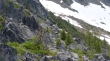
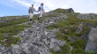
Five goats on the west side of the cliffy area... on the way to Third Burroughs Mtn.
|
BarbE taking a photo of the goats.
|
A pano shot from the west side of the cliffy area... Little Tahoma is peeking over the ridge (center)... Third Burroughs Mtn on the right.
|
BarbE and rodman adding snow to their water supply... the top of Skyscraper Mtn in the distance.
|
A parachutist's nightmare.
|
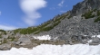
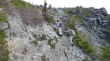
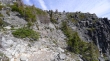
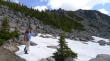
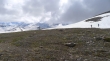
BarbE hiking along the west side of the cliffy area (~6500').
|
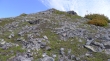
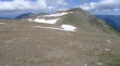
We have passed by the cliffy area and are gaining some elevation to decide on our next move to get over to Third Burroughs Mtn.
|
From here we can see Third Burroughs summit... the little snow dome above the cliffs on the right.
|
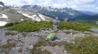
rodman taking a break before heading for Third Burroughs Mtn... Old Desolate (left) and the Sluiskins in the distance.
|
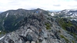
Looking through a gap to Skyscraper Mountain as we head for Third Burroughs.
|
rodman in search of Third Burroughs... Little Tahoma in the distance.
|
BarbE and rodman heading for the Third Burroughs summit.
|
Little Tahoma and Mt. Rainier as we head for the Third Burroughs summit.
|
Looking back at Second Burroughs Mountain.
|
BarbE and rodman are almost on the summit.
|
rodman and ragman taking the last few steps to the Third Burroughs summit.
|
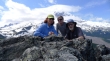
BarbE and rodman ready for the summit party.
|
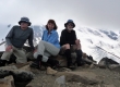
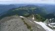
Group shot from the Third Burroughs summit (7828').
|
Skyscraper Mtn (left), Mt. Fremont (center) and Second and First Burroughs (right) from the Third Burroughs summit.
|
A pano shot from the Third Burroughs summit... Skyscraper Mtn on the far left to Little Tahoma on the far right... Goat Island Mtn is the big one in the right center.
|
Old Desolate and the Sluiskins from Third Burroughs Mtn... Mystic Lake on the left.
|
Goat Island Mtn (foreground)... Cowlitz Chimneys, Banshee Peak and Panhandle Gap on the right.
|
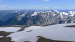
Winthrop Glacier from Third Burroughs.
|
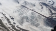
A closeup of Winthrop Glacier.
|
rodman and BarbE look for a good way down from Third Burroughs Mtn.
|
rodman and BarbE heading for Second Burroughs Mtn.
|
rodman and BarbE still descending from Third Burroughs Mtn.
|
Nearing the low point between Third Burroughs and Second Burroughs.
|
Little Tahoma is back in the clouds.
|
BarbE and rodman heading up toward Second Burroughs... ugh!!
|
Near the top of Second Burroughs now... BarbE and rodman looking back at Third Burroughs Mtn... Mt. Ruth and Steamboat Prow on the left.
|
ragman and BarbE taking life easy on Second Burroughs Mtn (7402')... Skyscraper Mtn on the left.
|
rodman on Second Burroughs Mtn.
|
BarbE on Second Burroughs Mtn... Little Tahoma in the distance.
|
Looking at First Burroughs Mtn... our next stop.
|
BarbE coming over to First Burroughs from Second Burroughs.
|
Two ways to get back to Sunrise... we are tired and will take the shortest way.
|
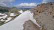
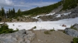
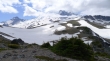
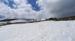
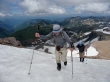
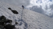
Snow on the north side of First Burroughs Mtn... very stubborn this year.
|
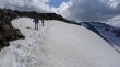
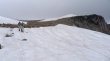
BarbE and rodman on the north side of First Burroughs Mtn... falling here is not an option.
|
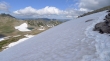
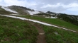
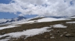
More and more snow on the north side of First Burroughs Mtn... Frozen Lake in the distance on the left... that's where we want to be... but there is still some snow work to deal with.
|
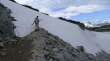
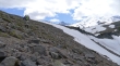
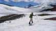
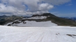
The last bit of snow travel is on very steep terrain.
|
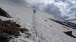
BarbE and rodman on the last bit of snow.
|
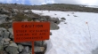
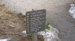
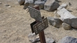
The National Park Service is giving fair warning... a couple miles of easy hiking are left to get back to the Sunrise Lodge.
|
