Points 10034, 10378 and 10440+ - 8.10.2011
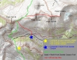
The second day of our '3 night, 4 day' backpack trip... we will relocate our camp from the pass that separates the Middle and North forks of Granite Canyon by using the Teton Crest Trail for a half-mile... then hike down the North Fork Granite Canyon Trail for another half-mile.
|
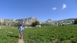
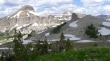
Denali Girl in the pass that separates the Middle and North forks of Granite Canyon... Point 10,116, Fossil Mtn and Mt. Bannon in the distance... after setting up camp we will be day hiking along the green ridge on the right.
|
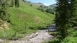
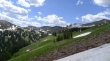
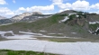
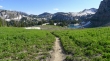
Losing elevation on the half-mile stretch of the Teton Crest Trail.
|
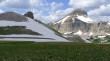
We will leave the Teton Crest Trail and head down the North Fork Granite Canyon trail for a half-mile and set up camp.
|
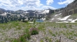
Nearing our campsite in the North Fork Granite Canyon.
|
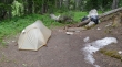
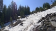
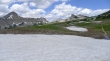
Our campsite in the North Fork Granite Canyon... when we get back from our day hike, the snow will be gone.
|
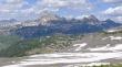
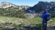
Heading cross country above our camp... angling back up Granite Canyon canyon toward Point 10,116.
|
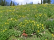
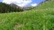
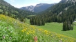
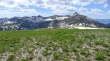
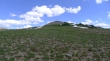
Flowers were abundant.
|
Looking down Granite Canyon to Rendezvous Mountain.
|
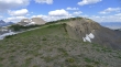
Working our way around steep cliffs now... Point 10,214 on the far right... our first night's camp was in the pass in the left center of the photo.
|
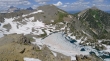
We can see the pass to the right of Point 10,116.
|
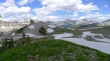
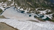
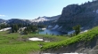
Looking down on Marion Lake from the pass east of Point 10,116.
|
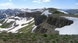
Looking NE to The Grand in the center of the photo... Fossil Mtn on the far left... Spearhead Peak (right foreground)... and the Teton Crest Trail (far right).
|
I've left the crest trail and heading cross country for Point 10,043... looking back to Point 10,116 in front of Housetop Mtn on the right.
|
On Point 10,043 now... Spearhead Peak (foreground) in front of Mt. Bannon (distant)... The Grand and Buck Mtn in the distance on the right.
|
A closeup of Fossil Mtn (left), Mt. Bannon (distant) and Spearhead Peak (foreground).
|
From Point 10,043 the next stop will be Point 10,378 on the right.
|
A pano shot from Point 10,043.
|
Looking back on Spearhead Peak and Fossil Mountain as I head for Point 10,378.
|
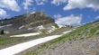
Nearing Point 10,378.
|
|
Looking back on Point 10,043 (foreground) from Point 10,378... Housetop Mtn is left-center in the distance... Fossil Mtn is far right.
|
Looking down into Death Canyon from Point 10,378.
|
A closeup of The Grand from Point 10,378... Buck Mtn on the right.
|
From Point 10,378 I'm going to head over to Point 10,440+ on the right.
|
Looking back on Point 10,378 from Point 10,440+.
|
Looking down on Indian Lake from Point 10,440+.
|
Indian Lake from Point 10,440+... The Grand and Buck Mtn are in the distance on the left... Point 10,905 (center) and Mt. Hunt (right).
|
On our return to camp we decided to follow the crest trail past Marion Lake and then connect with the Granite Canyon Trail.
|
Nearing Marion Lake.
|
Past Marion Lake now... ready to drop into Granite Canyon... leaving a half-mile hike to our campsite.
|
