Sherpa Peak - 9.1.2011
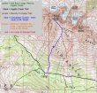
Our approximate route to Sherpa Peak... we did the summit on the middle day of a '3 day, 2 night' backpack trip... total elevation gain for the trip was ~7700 feet... with 4100 feet being on summit day.
|
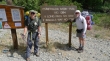
iraman and rocman at the Esmeralda Basin trailhead (4200')... at the end of the N. Fork Teanaway River Road.
|
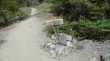
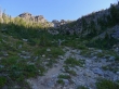
After a short hike, follow the Ingalls Way Trail.
|
After another short walk, follow the trail to Longs Pass.
|
iraman and rocman nearing Longs Pass.
|
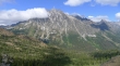
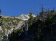
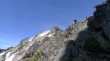
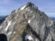
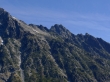
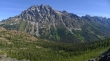
Mt. Stuart from Longs Pass.
|
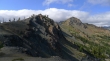
Point 6878 from Longs Pass.
|
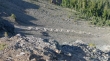
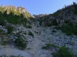
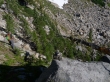
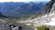
The 'S' curves leading from Longs Pass down toward Ingalls Creek.
|
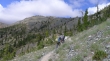
iraman heading down from Longs Pass.
|
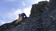
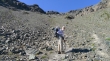
The next morning now... summit day... rocman and iraman are actually on very good path here... we are taking Beckey's Variation No. 1 route.
|
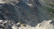
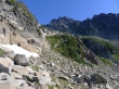
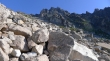
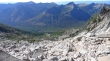
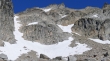
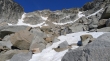
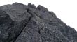
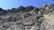
At ~6000 feet this gully begins to narrow and steepen.
|
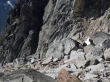
We are looking for a good place to exit this gully to the right.
|
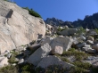
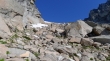
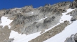
Out of the gully now and gaining elevation quickly.
|
Still trying to get above the steep gully.
|
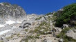
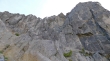
The steepness eases some at ~6600 feet.
|
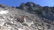
Off of the 'Variation No. 1 route' now... iraman is giving back 150 feet of elevation down into the gully that will take us to the west ridge of Sherpa Peak.
|
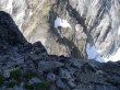
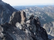
Sherpa Peak in the center of the photo.
|
Looking back at the 150 feet of elevation that we just gave up to get into this gully.
|
Looking back at Bill Peak (center)... Iron Peak and Teanaway Peak on the right.
|
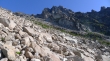
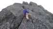
Ascending toward Sherpa Peak.
|
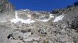
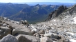
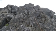
More and more rock to deal with as we get higher.
|
Getting closer, but still plenty of distance to go.
|
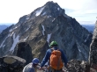
rocman and iraman gaining elevation.
|
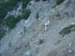
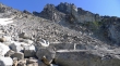
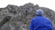
rocman in the boulder field... good luck finding him.
|
Looking back at some of the Teanaway Peaks.
|
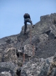
ragman in the rocks.
|
Mt. Stuart is up that way... somewhere.
|

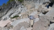
rocman and iraman are standing on Table Rock (7400')... really.
|
Again... rocman and iraman on Table Rock.
|
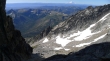
Looking up toward Mt. Stuart.
|
From Table Rock I'm looking back at the terrain we have traveled.
|
Looking up toward Mt. Stuart... still 800 feet of elevation to gain before we start using the rope.
|
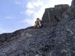
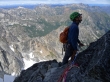
rocman and iraman (lower right) study the route notes while resting on Table Rock.
|
Some snow is a convenient diversion from all of the rock.
|
Looking up toward Mt. Stuart.
|
Looking back down the gully.
|
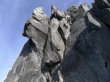
We have reached the summit block... are we really going up there?
|
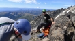
iraman and rocman putting on rock climbing gear... Mt. Stuart (center).
|
Looking down the gully... across the Teanaway Peaks to Mt. Rainier.
|
Almost ready to start climbing.
|
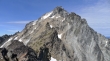
Mt. Stuart from the col between Sherpa and Stuart.
|
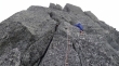
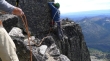
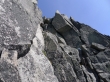
iraman leading the first pitch.
|
iraman on the first pitch.
|
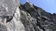
rocman leading...
|
rocman going higher...
|
Still higher...
|
rocman putting in a piece of protection...
|
and moving higher.
|
Looking across to Mt. Stuart.
|
Some of our gear is down there in the center of the photo.
|
iraman is watching rocman... Mountaineer Ridge is left of his pack... Axis Peak and Cashmere Mtn are above his head... Hi-Jack Peak and Eightmile Mtn are on the left.
|
Looking down at the Stuart/Sherpa col.
|
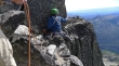
On a comfortable ledge here but we are off route... and iraman is looking at making a not so comfortable move to get around the corner.
|
First try... uh, lets try again.
|
Much better...
|
Just a little further.
|
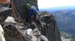
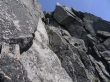
iraman leading pitch 5 that will get us up to the crux move.
|
iraman getting closer to the crux move.
|
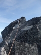
iraman just below the crux move... one more pitch will get us near the summit.
|
iraman is on the summit and looking back at us while we wait for our turn to touch the summit.
|
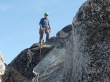
iraman on the Sherpa Peak summit (8605').
|
iraman got this shot of the Balanced Rock.
|
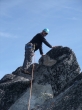
ragman making the second of two airy step-over moves.
|
ragman on the Sherpa Peak summit.
|
We didn't spend much time on the summit and are back to where we can see the Stuart/Sherpa col below.
|
rocman rappelling...
|
ragman being lowered down the last pitch... it is 6:00 p.m. and we need to get back to a good trail before it gets too dark to find our way.
|
The nex morning now... and time to pack all of the gear over Longs Pass and back to the car.
|
We can see Longs Pass in the center of the photo.
|
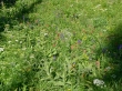
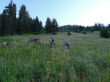
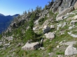
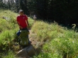
The flowers are hanging on very well.
|
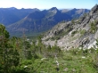
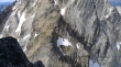
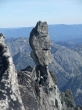
A closeup of Sherpa Peak (center) as we get closer to Longs Pass.
|
rocman and iraman near Longs Pass.
|
rocman very close to Longs Pass.
|
Mt. Stuart from Longs Pass.
|
Leaving Longs Pass... the hike to the car is all down hill from here.
|
