Earl Peak and Bean Peak - 11.10.2011
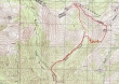
rodman's GPS route of our trip to Earl Peak and Bean Peak... 8 miles roundtrip, gaining 3849 feet of elevation.
|
From 29 Pines Campground... drive ~4 miles on the N. Fork Teanaway road... turn right just before crossing Beverly Creek and drive to the Beverly Turnpike trailhead (3600') at end of the road.
|
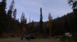
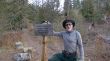
Uh oh... we may have to deal with 'Goats Gone Wild'... 27 degrees at the parking area.
|
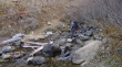
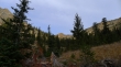
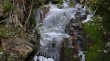
Beverly Creek at the parking area.
|
We hiked a half mile on trail #1391 (Beverly Turnpike) and turned right onto trail #1391.1 (Bean Creek).
|
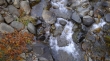
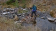
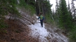
recon makes the first crossing (4100') of Bean Creek... a little slippery, but not that big of a deal.
|
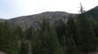
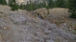
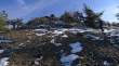
The first of two avalanche gullys as we continue on the trail towards Bean Creek Basin.
|
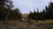
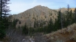
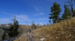
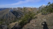
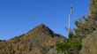
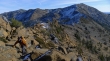
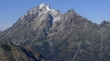
Shortly after crossing the second avalanche gully we got our first good look at Earl Peak.
|
An unsigned trail junction... the trail going straight goes into Bean Creek Basin... we will go to the right and cross Bean Creek for the second time.
|
rodman crossing Bean Creek (~5100').
|
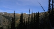
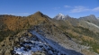
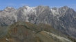
Looking up Bean Creek Basin as we head towards Earl Peak.
|
Confirmation of how cold it was.
|
Gaining elevation toward Earl Peak now... and looking back across the valley at Judy's Peak.
|
recon and rodman on the trail that will take us to the pass south of Earl Peak.
|
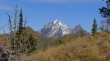
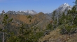
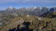
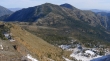
Mt. Stuart comes into view behind Bean Peak... Bean Creek Basin below... Mary's Peak on the far left.
|
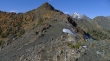
rodman and recon at the pass (~6200') south of Earl Peak.
|
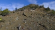
Heading north from the pass... gaining elevation on a good path.
|
A closeup of Bean Peak (behind the trees), Mt. Stuart and Sherpa Peak.
|
Looking south to Mt. Rainier.
|
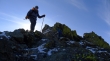
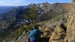
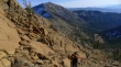
rodman ascending towards the Earl Peak summit.
|
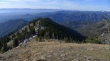
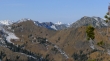
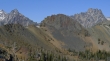
Looking across Bean Creek Basin to the snow covered peaks stretching from Snoqualmie Pass to Dutch Miller Gap.
|
Bean Peak in the foreground... with Bill's Peak (left), Fortune Peak, Ingalls Peak and Mt. Stuart.
|
Bears Breast Mountain is snow covered in the distance in the center of the photo... Chimney Rock and Overcoat Peak in the distance on the left.
|
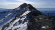
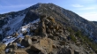
We can see the Earl Peak summit now.
|
rodman is on the summit and recon is almost there.
|
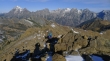
The Stuart Range from the Earl Peak summit (7036').
|
A pano shot of the Stuart Range... Stuart, Sherpa, Argonaut, Colchuck, Dragontail, Little Annapurna and McClellan.
|
Looking down on Bean Creek Basin... we will run the ridge on the right over to Bean Peak.
|
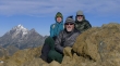
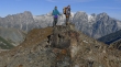
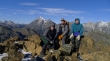
Group shot from the Earl Peak summit... rodman, ragman and recon... Stuart and Sherpa on the left.
|
rodman leads the way as we start our traverse over to Bean Peak.
|
recon and rodman heading for Bean Peak.
|
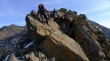
rodman and recon found a nice perch on the ridge.
|
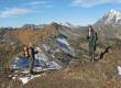
recon and ragman on the ridge... heading for Bean Peak (center).
|
Looking east at Navaho Peak and Three Brothers.
|
Looking back at the Earl Peak summit.
|
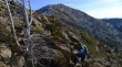
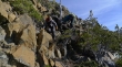
recon descending along the ridge.
|
rodman descending along the ridge.
|
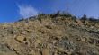
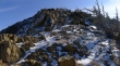
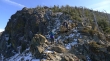
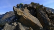
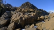
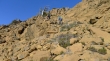
Very gnarly in places along the ridge... but there are plenty of options in dealing with them.
|
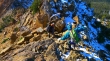
Just enough snow in places to keep us focused.
|
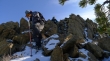
rodman in a squeeze.
|
Still need to give back some elevation.
|
We have given up ~600 feet of elevation from the Earl Peak summit.
|
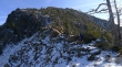
Now it will be a series of minor ups and downs over to the Bean Peak summit block.
|
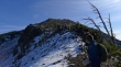
Looking back towards the Earl Peak summit (right in the distance).
|
rodman continues towards Bean Peak.
|
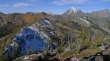
Break time with a nice look down on Bean Creek Basin... Judy's (left) and Mary's Peaks are in the center of the photo.
|
Looking back at Earl as we continue towards Bean.
|

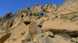
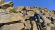
It doesn't have to be this difficult... but we were looking for an adventure.
|
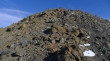
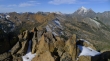
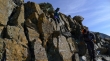
Definitely Class 2 climbing here... Earl Peak in the distance.
|
As hard as we are trying, there is still work to do to get over to Bean.
|
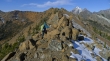
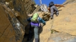
recon and rodman having some fun... again, it doesn't really have to be this much fun unless you want it to be.
|
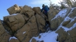
Easy does it rodman.
|
rodman, recon and rock.
|
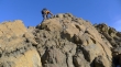
Class 2.
|
Bean Peak is trying to get closer to us.
|
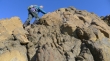
Finally... some easier terrain will get us over to the Bean Peak summit block.
|
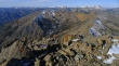
A pano shot showing Bean Peak and the Stuart Range.
|
A closeup of Volcanic Neck in the foreground... Sherpa Peak on the left and Argonaut Peak on the right.
|
At last... the Bean Peak summit block.
|
recon gaining elevation now... Navaho Peak on the far left... with Earl Peak on the right.
|
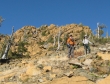
recon and rodman... up and up.
|
Still ascending... so many choices here.
|
recon leads the way... don't slip here.
|
So close now...
|
recon finishing off the last few steps to the summit.
|
rodman wasn't far behind.
|
Pano shot of the Stuart Range from the Bean Peak summit (6743').
|
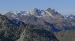
A closeup of Fortune Peak (left) and the three summits of Ingalls Peak... far right in the distance are Fish Eagle Peak and the south and north summits of Granite Mountain.
|
A closeup of Mt. Stuart and Sherpa Peak.
|
A closeup of Colchuck Peak, Dragontail Peak and Little Annapurna... Volcanic Neck and Devils Head are lower left.
|
Summit shot from the Bean Peak summit... ragman, recon and rodman.
|
Heading down now... accidentally had my camera on the 'Artist' setting... so in the future, please refer to me as an artist.
|
Heading for Bean Creek Basin (lower right)... Earl Peak in the distance.
|
recon and ragman below the Bean Peak summit block.
|
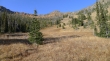
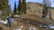
In Bean Creek Basin and looking back up at Bean Peak... back on pretty good trail here... about ready to close the loop portion of our hike... which will leave a couple of miles to get back to the car.
|
