Guye Peak - 5.7.2012
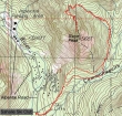
rodman's GPS route of our hike to the north summit of Guye Peak via Commonwealth Basin... 5.2 miles roundtrip, gaining 2240 feet of elevation.
|
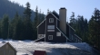
From Snoqualmie Pass, drive a short distance on the Alpental Road and look for the Sahalie Ski Club on your right... then park (2920') on the other side of the road from the ski club.
|
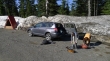
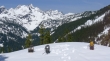
rodman and BarbE gearing up across the street from the Sahalie Ski Club.
|
Looking down the Alpental Road to Snoqualmie Mountain.
|
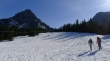
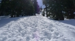
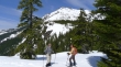
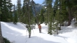
rodman and BarbE heading up the ski area toward Guye Peak (left).
|
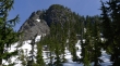
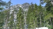
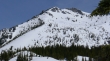
At the top of the ski club area... the south face of Guye Peak looks intimidating... and we will not be going up it.
|
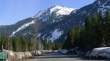
Looking across I-90 to the Snoqualmie Pass Ski Area... Abiel Peak (left) and Silver Peak in the distance.
|
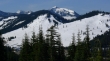
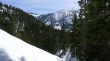
Looking up valley toward the Alpental Ski Area... with Chair Peak at the head of the valley.
|
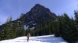
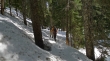
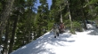
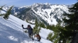
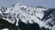
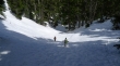
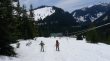
Working our way around the south side of Guye Peak into Commonwealth Basin.
|
On the east side of Guye Peak.
|
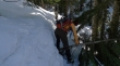
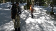
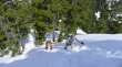
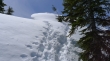
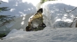
A few obstacles along the way.
|
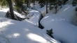
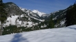
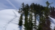
Staying between Guye Peak and one of the Commonwealth Creek tributaries.
|
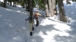
rodman checking his GPS.
|
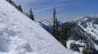
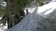
Steeper terrain now... heading up toward the saddle between Cave Ridge and Guye Peak.
|
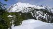
The NE side of Guye Peak as we head for the saddle between Guye and Cave Ridge.
|
BarbE and rodman are doing the heavy lifting.
|
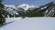
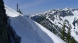
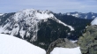
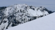
Almost to the saddle now... looking across Commonwealth Basin to Kendall Peak.
|
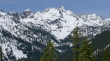
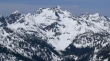
A nice view from the saddle (4600')... The Tooth, Bryant, Chair, Roosevelt and Preacher.
|
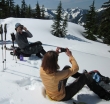
Let the photo shoot begin... Snoqualmie Mountain above.
|
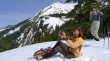
rodman takes a photo of me taking a photo of him.
|
A closer look at The Tooth (far, far left), Bryant, Chair and Roosevelt.
|
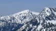
Snoqualmie Mountain from the saddle.
|
Leaving the snowshoes behind as we head for the summit.
|
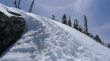
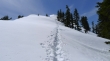
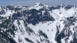
Pretty obvious that our route has been traveled recently... the crux of the trip will be getting around the rock outcropping at the top of the photo.
|
Much steeper terrain now... Denny Mountain across the valley.
|
Up and up as we head for the rock outcropping.
|
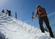
At the rock outcropping... a mistake here is unacceptable.
|
At the rock outcropping... Denny Mountain on the right.
|
Only 20 steps remain to reach easier terrain... is that a sundog forming in the sky?
|
ragman nearing the easier terrain.
|
Easier now.
|
Looking back at Snoqualmie Mountain and Lundin Peak.
|
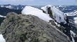
The north summit of Guye Peak is in view.
|
Real close to the north summit now.
|
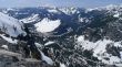
On the north summit (5168')... looking across to the south summit... Rampart Ridge on the left.
|
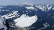
Looking across the Snoqualmie Pass Ski Area to Ollalie Meadows, Tinkham Peak, Abiel Peak, Silver Peak and on to Mt. Rainier... Humpback Mountain on the far right.
|
Kendall Peak (left) and Rampart Ridge.
|
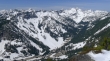
Granite Mtn (far left in the distance), Denny Mtn, The Tooth, Bryant Peak, Chair Peak, Mt. Roosevelt, Preacher Mtn and Wright Mtn... Alpental Ski area across the valley and below.
|
Pano shot showing Bryant, Chair, Roosevelt, Preacher and Wright in the distance... with Snoqualmie and Lundin in the right foreground.
|
Zoom shot showing the cornices on Granite Mountain.
|
Zoom shot of Denny Mountain.
|
Zoom shot of Bryant Peak, Chair Peak and Mt. Roosevelt.
|
Looking down on Snoqualmie Pass and the Alpental community... Rainier in the distance.
|
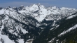
A closeup of The Tooth, Bryant, Chair, Roosevelt, Preacher and Wright.
|
A closeup of Red Mountain... with Lemah and Chikamin peaking over the ridge.
|
A closeup of Kendall Peak.
|
Coming down from the rock outcropping.
|
The snow is getting sloppy in the warm temperature.
|
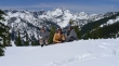
Group shot... rodman, BarbE (eating a snow sandwich) and ragman.
|
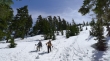
We will use our snowshoes from the saddle back to the car.
|
Heading down from the saddle into Commonwealth Basin.
|
Still 10 feet of snow in Commonwealth Basin... wow.
|
Being extra careful as we traverse above the creek.
|
Almost back to the ski club.
|
We can see the ski club... a beautiful day in the mountains.
|
