Point 6878 (aka 'Not Hinkhouse' Peak) - 6.14.2012
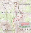
No GPS today... after hiking the Esmeralda Basin Trail for a quarter mile, there was so much snow that we made our own trail up to the ridge between Longs Pass and Ingalls Pass... the hike was ~6 miles roundtrip, gaining ~2800 feet of elevation.
|
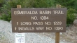
Find the trailhead by driving FS 9737 from 29 Pines Campground to the end of the road.
|
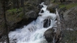
The North Fork of the Teanaway River was raging.
|
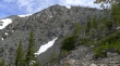
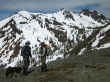
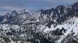
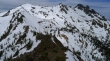
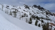
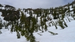
The west and north summits of Esmeralda Peaks.
|
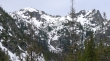
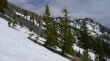
Still plenty of snow just a couple hundred feet above Esmeralda Basin.
|
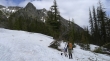
Fortune Peak as we head up toward the ridge.
|
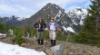
Snowdog and larman... with the east and west summits of Esmeralda Peaks behind... Koppen Mountain on the far left.
|
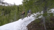
Heading up.
|
Izzy relaxing... wonder why it is taking us so long.
|
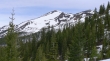
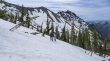
Still gaining elevation... Esmeralda Peaks across the valley.
|
Still gaining elevation... the ridge behind is running south... and eventually leads over to Teanaway Peak.
|
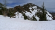
Fortune Peak.
|
We will stay on this side of the gully on the way up to the ridge.
|
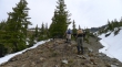
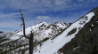
Still climbing... with Esmeralda Peaks and Hawkins Mountain.
|
Off the snow now and still climbing.
|
Izzy watches larman and Snowdog work.
|
Almost to the ridge now.
|
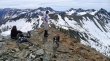
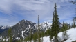
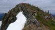
We reached the ridge at ~6500 feet... northwest of Longs Pass... Lots of Teanaway Peaks in the distance.
|
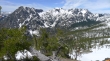
Mt. Stuart and the Stuart Range... Jack Ridge is left of Mt. Stuart... Ingalls Creek drainage is lower right.
|
We will follow the ridge over to 'Not Hinkhouse' Peak (right).
|
On the way to 'Not Hinkhouse' (right)... Fortune Peak and the three summits of Ingalls Peak come into view.
|
Looking back... Longs Pass is the low point in the center of the photo... Bill Peak and Teanaway Peak are in the top center of the photo.
|
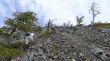
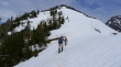
One more ridge bump to get over before we can head up to 'Not Hinkhouse'.
|
Snowdog and larman on the ridge.
|
Snowdog, larman and Izzy on the ridge... Fortune Peak and Ingalls Peak in the distance.
|
Almost ready for the final push up to 'Not Hinkhouse' Peak... lots of serpentine here.
|
Izzy, ragman and Snowdog in the field of serpentine.
|

Giving back a little elevation here.
|
Izzy and Snowdog will use the moat to get around this rock outcropping.
|
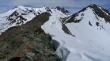
Clear sailing ahead now.
|
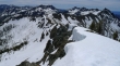
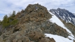
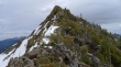
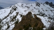
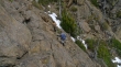
Looking back at the ridge we have traveled to reach the south end of 'Not Hinkhouse' Peak.
|
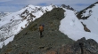
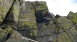
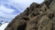
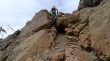
Izzy watches larman set the steps for Snowdog and me.
|
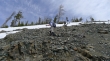
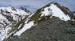
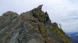
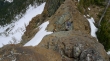
Snowdog nearing the summit block.
|
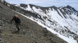
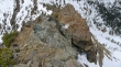
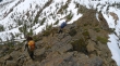
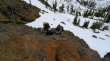
Snowdog does some Class 2 climbing.
|
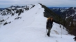
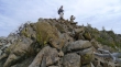
Snowdog summits (6878')... with larman close... Mt. Stuart on the right.
|
Fortune Peak and Ingalls Peak from 'Not Hinkhouse'... Ingalls Pass is below left.
|
Izzy, Snowdog and larman on the 'Not Hinkhouse' summit... looking at Esmeralda Peaks, Hawkins Mountain and Fortune Peak.
|
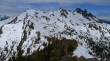
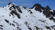
The Stuart Range from 'Not Hinkhouse'... Jack Ridge is left of Mt. Stuart.
|
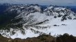
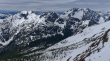
Looking south and southeast from 'Not Hinkhouse' Peak... visible Teanaway peaks include Three Brothers, Navaho, Earl, Bean, Volcanic Neck, Devils Head, Bill Peak and Teanaway Peak... Longs Pass is right center.
|
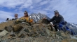
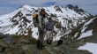
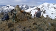
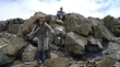
Group shot from the summit... Izzy, larman, Snowdog, Mt. Stuart and ragman.
|
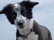
Miss Isabel on the 'Not Hinkhouse' summit.
|
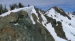
Esmeralda Peaks and Hawkins Mountain.
|
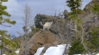
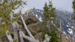
A closeup of the three summits of Ingalls Peak.
|
Looking across Stuart Pass to Jack Ridge (right) leading over to Hi-Jack Peak (left center).
|
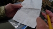
larman found the unofficial summit register... and Snowdog signed us in.
|
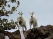
I started to head down toward Ingalls Pass and two baby goats were heading up to greet me.
|
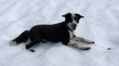
A baby goat... framed.
|
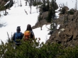
larman,Snowdog and Izzy checking out the goats.
|
Looking back at 'Not Hinkhouse' as we head down toward Ingalls Pass.
|
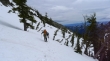
Serpentine on the ridge leading down to Ingalls Pass.
|
Take it easy here.
|
Working our way down to Ingalls Pass (left center).
|
Looking back to 'Not Hinkhouse'.
|
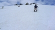
Snowdog and larman continue down.
|
Whew!!... having fun now.
|
Ride'em cowgirl.
|
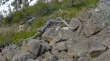
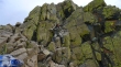
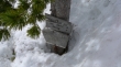
The two goats (white spots on the brown rock in the foreground) are showing us the way down.
|
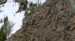
A closer look at the baby goats.
|
Look ma... no hands.
|
If a goat can do it... so can Snowdog.
|
We found a place that Izzy didn't like... so...
|
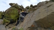
Izzy, Snowdog and larman back track a short distance to look for a better route for Izzy.
|
Izzy likes this route a little better.
|
Snowdog and Izzy go over the last obstacle before Ingalls Pass.
|
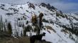
ragman and Snowdog check out the goats... just above Ingalls Pass now.
|
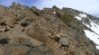
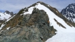
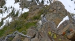
The very fun scramble route on the NW ridge of 'Not Hinkhouse'... mostly Class 2 with some Class 3 if that is your choice.
|

Just above the goats at Ingalls Pass.
|
Snowdog and Izzy check out the goats at Ingalls Pass.
|
Fortune Peak and Ingalls Peak from Ingalls Pass.
|
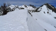
Still at least 4 feet of snow in Ingalls Pass.
|
Looking at 'Not Hinkhouse' Peak from Ingalls Pass.
|
The baby goats really like to pose.
|
The baby goats... with Mt. Stuart in the distance.
|
larman got this shot of the baby goats.
|
Heading down from Ingalls pass now... no sign of the trail.
|
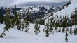
Heading down toward Esmeralda Basin now... Esmeralda Peaks and Hawkins Mountain in the distance.
|
Looking back toward Ingalls Pass.
|
We got tired of side-hilling real fast... and decided to take a more direct route down to Esmeralda Basin.
|
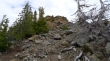
Finally back to easier terrain... this was part of a huge slide that completely wiped out the junction of the Ingalls Way trail and the Esmeralda Basin Trail.
|
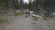
Back on the Esmeralda Basin Trail... only a quarter mile of hiking to get back to the car.
|
