Snowgrass Mountain and Frosty Mountain - 7.31.2012
|
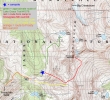
Our approximate route from Lake Grace to our campsite (5500') north of Frosty Pass... then up to Snowgrass Mtn... then down to Frosty Pass (5700') and up to Frosty Mtn (6489')... and finally back to camp... ~7 miles roundtrip, gaining ~3600 feet of elevation.
|
A google earth look at today's hike from the west side of Snowgrass Mountain.
|
A google earth look at today's hike from the east side of Snowgrass Mountain.
|
Leaving Grace Lake after camping here for two nights.
|
Goodbye Grace Lake... thanks for the memories... Big Chiwaukum above.
|
|
On the Grace Lake Trail and heading toward Frosty Pass.
|
Switchbacking down from Grace Lake... Bulls Tooth on the right.
|
Continuing on the Grace Lake Trail and heading toward Frosty Pass... Frosty Mountain on the right.
|
Almost back to the junction with the Frosty/Wildhorse Trail.
|
At the trail junction... solman and I will continue toward Frosty Pass for another third of a mile and set up camp for a third night... while everyone else heads for their cars.
|
|
We will set up camp in the meadow just beyond the snow on the right... Frosty Pass (center) and Frosty Mountain (right) are above.
|
We have set up our camp and will be heading up the gully in the center of the photo on our way to Snowgrass Mountain.
|
The beginning of our route from camp to Snowgrass Mountain... using the gully on the north side of Point 7161 to get to the high country.
|
solman in the gully on the north side of Point 7161... with the Wildhorse drainage in the valley below.
|
Continuing up the gully.
|
|
Continuing up the gully.
|
Looking down the gully as we continue up... Frosty Pass and Frosty Mountain in the left foreground... Bulls Tooth in the distance.
|
Continuing up the gully.
|
Continuing up the gully... the terrain is starting to ease a bit.
|
Almost at the top of the gully now.
|
|
Nearing the top of the gully because we can see Ladies Peak coming into view.
|
Pano shot of Ladies Peak.
|
A closer look at the west side of Ladies Peak.
|
Looking at the south ridge of Snowgrass Mountain... it looks like easy terrain, but if you try to take it to the top, you will get cliffed out... instead, we will cross over the pass on the upper right.
|
A closeup of Glacier Peak.
|
|
solman starts up for the 7400 foot pass.
|
On a good path and heading for the 7400 foot pass.
|
At the 7400 foot pass now... looking over to Big Jim Mountain, Big Lou Mountain and Frigid Mountain... Cashmere Mountain in the distance on the far right.
|
A closeup from the 7400 foot pass... Ladies Pass and Cape Horn in front of Cashmere Mountain... Frigid Mountain on the far left.
|
We will cross over to the east side of the 7400 foot pass.
|
|
On the east side of the 7400 foot pass... traversing around to where we can see the Snowgrass Mountain summit area.
|
On the east side of the 7400 foot pass... traversing around to where we can see the Snowgrass Mountain summit area.
|
Looking down on Lake Flora (left) and Lake Brigham.
|
Continuing around toward the summit area.
|
Looking back to the 7400 foot pass (upper right)... Ladies Pass is in the center of the photo... with Cashmere Mountain and the Stuart Range beyond.
|
|
Not exactly sure where the summit is, but we will continue on a rising traverse.
|
Continuing on the snow fields on the east side of Snowgrass.
|
We know we are in the correct vicinity of the summit because we could see the spire (left center) when we were camped at Grace Lake... and we know that the Snowgrass summit is to the left of the spire.
|
Alternating between rock and snow now.
|
Looking back... showing our general route from the 7400 foot pass to where we are now.
|
|
Getting close now.
|
Still working toward the spire... but will turn and head straight up when we get to the next band of rock.
|
The summit is directly above now.
|
Almost there.
|
solman nears the summit ridge.
|
|
Will that be the true summit?
|
Looking back from the summit ridge... Opportunity Mountain is between the two pyramids on the right.
|
Okay... will this be the true summit?
|
solman with the Snowgrass Mountain summit register.
|
The 7400 foot pass is in the right foreground... Cape Horn, Ladies Pass and Ladies Peak are in the foreground... looking across Ladies Pass and Grindstone Mountain to Cashmere Mountain and the Stuart Range in the distance.
|
|
Looking down on Frosty Pass and Frosty Mountain in the right foreground.
|
Grace Lake (left), Upper Grace Lake and Big Chiwaukum from the Snowgrass summit... with Glacier Peak in the distance.
|
A closeup of Big Chiwuakum... looking across Arrowhead Mountain and Rock Mountain to Glacier Peak in the distance.
|
Ladies Pass and Ladies Peak in the foreground... with Grindstone behind Ladies Pass... and the Stuart Range on the horizon... Ingalls Peak to the right of Mt. Stuart.
|
ragman and solman on the Snowgrass Mountain summit (7993').
|
|
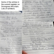
There are a lot of nwhiker names in the summit register.
|
Big Jim and Big Lou on the left... time to head down.
|
solman coming down from the summit.
|
Heading back to the 7400 foot pass.
|
Heading back to the 7400 foot pass.
|
|
Heading back to the 7400 foot pass.
|
Back at the 7400 foot pass... you cannot see the summit from the pass.
|
Our general route down to Frosty Pass and then up to the summit of Frosty Mountain.
|
Coming down from the 7400 foot pass.
|
Ladies Peak.
|
|
Point 7161 in the foreground... we will hike along that ridge and find a way down to Frosty Pass.
|
Looking down the gully that we used to get up to this area from our camp.
|
solman on Point 7161.
|
Looking down on Lake Mary from Point 7161.
|
Taking a break on Point 7161... with Ladies Peak on the right.
|
|
Big Chiwaukum and Snowgrass Mountain from Point 7161.
|
Time to start heading down from Point 7161.
|
Hiking toward Lake Mary for a short distance.
|
Now hiking down from Point 7161 toward Lake Margaret... Frosty Pass is just out of frame on the right.
|
Nice flowers on this slope.
|
|
solman continuing toward Lake Margaret and Frosty Pass.
|
Looking back up toward Point 7161.
|
Nearing Frosty Pass... with Frosty Mountain behind.
|
Looking back at Point 7161.
|
Big Chiwaukum and Snowgrass Mountain from Frosty Pass.
|
|
At Frosty Pass (5700') now... we will continue on a portion of Icicle Ridge Trail #1570 that goes over to the NE side of Frosty Mountain and find an open slope that will make it easy to get to the summit.
|
We have found an easy open slope on the NE side of Frosty Mountain.
|
solman heads for the Frosty Mountain summit.
|
Almost on the summit ridge now.
|
Heading for the bump on the left.
|
|
solman on the summit (6489') of Frosty Mountain.
|
The Frosty Mountain summit register... but we weren't able to get it open.
|
A pano shot of Big Chiwaukum (left), Snowgrass Mountain and Ladies Peak from the summit of Frosty Mountain.
|
Coming back down from the Frosty Mountain summit... where we will get back on Icicle Ridge Trail #1570 and follow it back to Frosty Pass... then take the Wildhorse Trail for a half-mile to our campsite.
|
On the north side of Frosty Pass now and very near our campsite... we will hike back to our car tomorrow morning... what a trip!
|


