Lembert Dome, Dog Dome and Olmstead Point - 8.12.2012
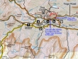
This short hike offers a get-acquainted trip with Yosemite National Park and a chance to get used to the the elevation... the hike to Lembert Dome and Dog Dome is 2.4 miles roundtrip, gaining 900 feet of elevation.
|

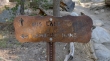
Find the trailhead by driving the Tioga Road 6.4 miles from the Tioga Pass entrance to Yosemite Nat. Park... turn left... pass by the Wilderness Permit office... then pass by the Tuolumne Meadows Ranger station and park at the Dog Lake parking area (8680').
|
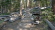
A lot of hard work has been done on this trail.
|
After hiking a half-mile, head for Lembert Dome at this junction.
|
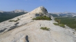
Out of the forest now... with Lembert Dome in our face.
|
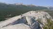
Denali Girl coming up to the Lembert Dome summit... Tuolumne Meadows on the left and right... with the Cathedral Range above.
|
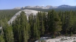
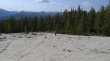
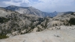
Looking NW to Dog Dome... we will go over there on the way back to the car.
|
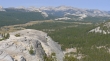
Tuolumne Meadows from Lembert Dome.
|
Denali Girl coming down from Lembert Dome.
|
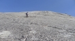
Denali Girl coming up to Dog Dome.
|
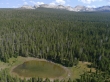
Looking down on Dog Lake from the top of Dog Dome.
|
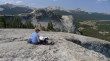
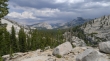
Denali Girl studies the map on Dog Dome... looking over to Lembert Dome... with the Cathedral Range in the distance... and Tuolumne Meadows on the right.
|
Olmstead Point is a several mile drive on the Tioga Road from the Dog Lake trailhead... it offers a very short hike for improved views of Tenaya Lake, Clouds Rest and Half Dome.
|
From Olmstead Point we are looking down Tenaya Canyon to Clouds Rest (left) and Half Dome.
|
From Olmstead Point we are looking at Tenaya Lake (center), Polly Dome (left) and Tenaya Peak (right).
|
