Vogelsang Peak - 8.23.2012
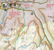
We did this trip as a 3 day backpack... starting from the Dog Lake parking area, we used the John Muir and Lyell Canyon trails for a short distance... then followed the Rafferty Creek drainage for 4.9 miles to Tuolumne Pass (9992').
|
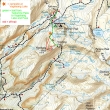
From Tuolumne Pass we continued .8 miles to the Vogelsang High Sierra Camp (10,130')... then continued another half-mile to Vogelsang Lake (10340') and set up our base camp.
|
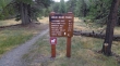
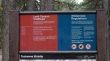
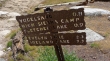
Find the trailhead by driving the Tioga Road 6.4 miles from the Tioga Pass entrance to Yosemite Nat. Park... turn left... pass by the Wilderness Permit office... then pass by the Tuolumne Meadows Ranger station and park at the Dog Lake parking area (8680').
|
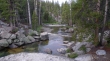
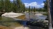
Follow the Dana Fork of the Tuolumne River for a short distance.
|
Take the Lyell Canyon trail which is also the John Muir Trail and the Pacific Crest Trail.
|
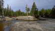
Crossing the Lyell Fork of the Tuolumne River.
|
After hiking a total of about 1.3 miles, we left the Lyell Canyon trail and headed south for the Vogelsang High Sierra Camp... following along Rafferty Creek.
|
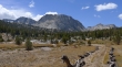
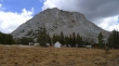
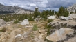
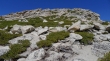
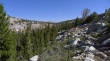
Johnson Peak.
|
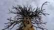
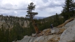
Tree.
|
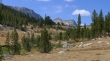
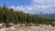
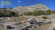
Approaching Tuolumne Pass... Fletcher Peak (left) and Vogelsang Peak in the distance.
|
Clouds forming behind us.
|
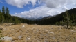
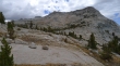
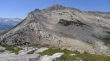
Getting closer to Tuolumne Pass.
|
Horses packing goods to the Vogelsang High Sierra Camp... this happens every day that the camp is open... they need to feed and house 50 people each day.
|
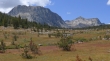
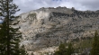
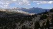
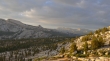
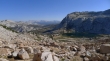
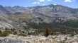
The closer we get to Tuolumne Pass, more peaks come into view... Parsons Peak is on the far left.
|
We have reached Tuolumne Pass (9992').... leaving .8 miles to the High Sierra Camp and another half-mile to Vogelsang Lake.
|
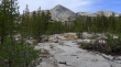
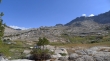
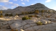
An unnamed point to the west near Rafferty Peak.
|
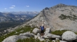
Denali Girl taking a break on the south side of Tuolumne Pass... on the way to the Vogelsang High Sierra Camp.
|
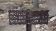
Arriving at the Vogelsang High Sierra Camp (10,130')... at the foot of Fletcher Peak.
|
From the High Sierra Camp it is 1.2 miles to Vogelsang Pass, but we only have to go another half-mile to reach Vogelsang Lake.
|
Vogelsang Peak from the High Sierra Camp.
|
Denali Girl approaches Vogelsang Lake... the High Sierra Camp is in the trees on the left.
|
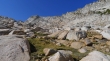
Nearing Vogelsang Lake... with clouds building quickly.
|
Looking across Tuolumne Pass to Mt. Conness and White Mountain in the sunshine... the High Sierra Camp is in the trees on the left.
|
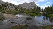
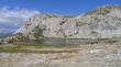
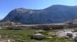
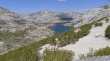
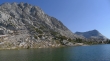
We have reached Vogelsang Lake... Vogelsang Pass on the left... with the summit of Vogelsang Peak on the right, just left of the two small clouds.
|
Vogelsang Lake and Fletcher Peak... after riding out a two hour rain storm in the tent, I decided to hike up to Vogelsang Pass and do a little exploring.
|
Looking down on Vogelsang Lake as I near Vogelsang Pass.
|
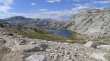
From Vogelsang Pass... Gallison Lake (left) and Bernice Lake (right)... and some of the peaks of the southern Cathedral Range.
|
Fletcher Peak from our campsite at Vogelsang Lake... clouds are forming again.
|
From our campsite we are looking across Tuolumne Pass to Mt. Conness and White Mountain.
|
Vogelsang Peak from our campsite.
|
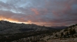
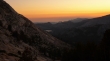
Red sky over Tuolumne Pass.
|
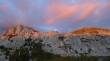
Sunset over Fletcher Peak.
|
The next morning... not a cloud in the sky... and my route to the Vogelsang Peak summit and then down and over to Vogelsang Pass.
|
Denali Girl (center of photo) will continue to Vogelsang Pass while I head for Vogelsang Peak.
|
A distant look at the Class 2 gully leading up to the summit ridge.
|
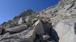
Looking back at the lake as I work my way up the gully.
|
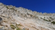
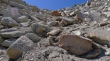
Most of the east side of Vogelsang is very rugged... but there is a line of weakness that offers a Class 2 scramble to the ridge.
|
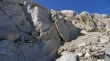
Looking back as I get higher up the gully.
|
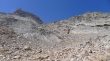
Looking up the gully.
|
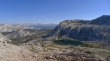
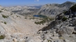
A pano shot from near the top of the gully... Vogelsang Lake below Fletcher Peak on the left... looking across Vogelsang Pass on the far right to Gallison Lake and peaks of the southern Cathedral Range.
|
The last short section to the ridge almost looks like a trail.
|
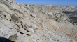
The northern part of Vogelsang's east face is very gnarly.
|
Pano shot from the north ridge of Vogelsang... looking NW to NE.
|
Granite anyone?
|
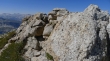
The Vogelsang Peak summit (11,516').
|
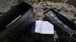
The Vogelsang summit register.
|
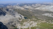
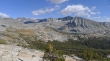
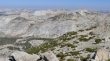
Looking west from the Vogelsang summit... Emeric Lake is the largest... Half Dome and Clouds Rest are left center.
|
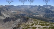
A pano shot looking NW to NE.
|
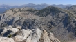
Looking East to SE from the Vogelsang Peak summit.
|
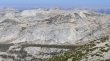
Looking across Fletcher Peak to Mt. Dana and Mt. Gibbs on the horizon in the center of the photo.
|
Matthes Crest (left center)... with Echo Peaks and Echo Ridge in the center.
|
Coming down on the east side of the summit.
|
At the Class 1 gully that I will go down.
|
Looking up to the top of the gully.
|
Down from the gully now... summit on right... time to head over to Vogelsang Pass and meet Denali Girl.
|
At Vogelsang Pass now... with views of the southern Cathedral Range.
|
Denal Girl on the north side of Vogelsang Pass... Vogelsang Peak is behind... with the Clark Range in the distance.
|
Vogelsang Peak... at the bottom of the photo you can see the trail coming up to Vogelsang Pass from the lake.
|
Vogelsang Lake from above Vogelsang Pass... time to head down and go have dinner at the Vogelsang High Sierra Camp.
|
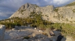
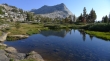
We are at Fletcher Lake (an eighth of a mile past the Vogelsang High Sierra Camp)... Vogelsang Peak on the right.
|
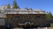
The Vogelsang High Sierra Camp.
|
Vogelsang Peak from the High Sierra Camp.
|
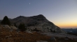
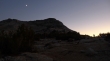
The moon over Vogelsang will complement the sunset.
|
Sunset from our campsite... we can see Emeric Lake and Half Dome down valley.
|
The spotlight is on Denali Girl.
|
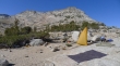
Drying out our gear on day 3... time to head back to the car.
|
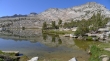
Lake reflection as we leave Vogelsang Lake.
|
Heading for Tuolumne Pass.
|
Back at the crossing of the Lyell Fork of the Tuolumne River... beautiful... Mt. Dana and Mt. Gibbs are on the horizon.
|
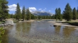
A look at Mammoth Peak from the Lyell Fork of the Tuolumne River... just over a mile remains to reach the car.
|
