North Peak - Yosemite National Park - 8.28.2012
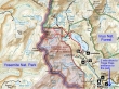
North Peak is on the eastern border of Yosemite National Park, but 99 percent of this hike is in the Hoover Wilderness of the Inyo National Forest.
|
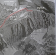
This aerial photo from R. J. Secor's "The High Sierra" shows the sheer north face of North Peak... and my approximate route to the top via the east and west sides of the peak's south ridge.
|
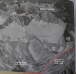
This aerial photo from R. J. Secor's "The High Sierra" shows the north side of Mount Conness... and my approximate route from the highest of the Conness Lakes to the south ridge of North Peak.
|
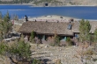
Saddlebag Lake Resort (10,087') is located in the Inyo National Forest next door to Yosemite National Park... ~2 miles before reaching the Tioga Pass entrance to Yosemite Nat Park, turn right and drive ~2 miles to the primitive resort.
|
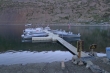
We chose to take a water taxi ($7 one way) from the resort to the north end of the lake... saving 1.4 miles of hiking.
|
On the water taxi and heading for the north end of Saddlebag Lake... Shepherd Crest in the distance.
|
Still on the water taxi... with North Peak coming into view.
|
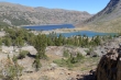
Off of the boat now... looking back across Saddlebag Lake to Mt. Dana in the distance.
|
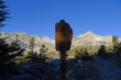
Entering the Hoover Wilderness which is managed by the Inyo National Forest... Mount Conness on the left side of the sign... and North Peak on the right.
|
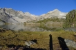
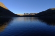
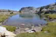
Mt. Conness and North Peak from Greenstone Lake.
|
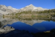
Mount Conness and North Peak reflection in Greenstone Lake.
|
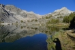
Another reflection shot... we will follow the boot path around the lake and follow the water up to Conness Lakes.
|
Entering the Monroe Hall Research Natural Area.
|
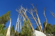
Tree shot.
|
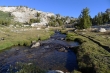
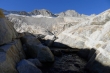
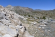
Even in this very dry season, there is still plenty of water flowing down from Mount Conness and Conness Lakes.
|
The boot path will take us up along the right side of the falls... Denali Girl is in the bottom of the photo... North Peak above.
|
A closeup of North Peak and the falls.
|
Above the waterfall now and heading over toward it... Mount Conness is through the gap.
|
Looking back down on Saddlebag and Greenstone Lakes... with the Tioga Crest on the horizon.
|
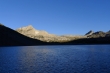
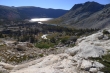
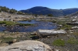
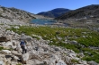
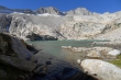
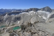
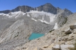
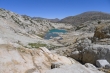
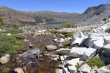
The first of the Conness Lakes... Mount Conness and North Peak above.
|
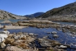
Looking back at the water running from the first Conness Lake.
|
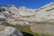
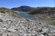
Pano shot of the first Conness Lake... with Mount Conness and North Peak above.
|
Denali Girl going around the first lake... we will follow the water up to the next lake.
|
Continuing around the first lake.
|
Looking back.
|
Denali Girl working her way up toward the second Conness Lake.
|
Looking back.
|
We can hear the water below the rocks... and are heading for the gap above.
|
We can see the water now.
|
Almost to the second lake now... Mount Conness above.
|
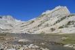
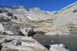
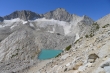
The second Conness Lake.
|
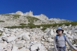
ragman at the second Conness Lake... with North Peak above.
|
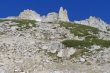
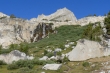
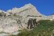
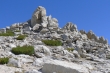
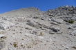
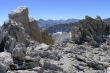
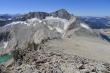
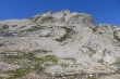
A closer look at the interesting rock formations at the North Peak summit area.
|
Heading for the North Peak summit ridge now... and I can see two more of the Conness Lakes above the green one.
|
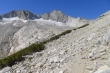
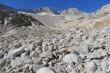
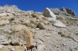
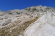
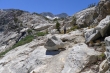
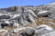
Steeper terrain now... but I am following a faint path.
|
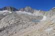
High enough now to see the tarn below Mount Conness and North Pass.
|
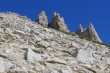
Looking up at the rock formations near the North Peak summit.
|
Gaining elevation... looking down on the tarn below Mount Conness.
|
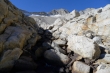
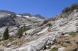
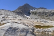
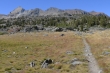
The terrain has eased a bit just below the south ridge of North Peak.
|
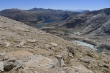
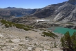
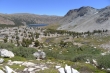
Three of the four Conness Lakes on the right... with Saddlebag Lake at the top of the photo.
|
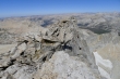
Almost on the south ridge of North Peak.
|
Summit in view on the left... it will be a stroll from here... with the terrain on the west side of the south ridge being very gentle.
|
It is almost flat here on the south ridge... Mount Conness and the Conness Glacier on the left... Yosemite peaks in the distance on the right.
|
Looking across the east ridge of Mount Conness to the distant peaks of Parker Peak, Koip Peak and Kuna Peak on the left... Mt. Ritter and Banner Peak are on the far right.
|
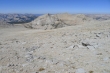
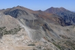
Sheep Peak from the south ridge of North Peak.
|
Looking through the rock formations to Mt. Dana, Mt. Gibbs, Parker Peak, Koip Peak and Kuna Peak.
|
Pano shot of Mount Conness from the south ridge of North Peak.
|
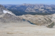
Roosevelt Lake comes into view as I ascend North Peak... Half Dome is on the far left.
|
Looking down on Twenty Lakes Basin as I ascent North Peak.
|
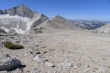
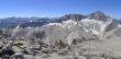
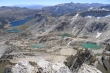
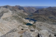
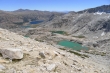
A pano shot from the North Peak summit (12,242')... Twenty Lakes Basin on the left... Saddlebag Lake and Greenstone Lake in the center... with Conness Lakes below right.
|
Saddlebag and Greenstone Lakes above and on the left... with Conness Lakes below.
|
From the summit... Sawtooth Ridge in the distance on the right.
|

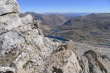
Roosevelt Lake... with Sheep Peak in the right foreground.
|
Mount Conness... with the upper Conness Lake on the left... and Roosevelt Lake on the right.
|
Mount Conness with the Conness Lakes below... distant peaks are Mt. Dana on the far left... with Gibbs, Parker, Koip, Kuna, part of the Ritter Range and part of the Cathedral Range... with Mount Lyell in the center of the photo with the huge glacier on it.
|
Twenty Lakes Basin.
|
Secret Lake (11,000') at the bottom of the photo... with the eastern end of Shepherd Crest, Excelsior Mountain and Mount Olsen behind.
|
So many peaks... so little time.
|
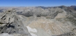
Pano shot of Twenty Lakes Basin.
|
Twenty Lakes Basin (left and center)... Saddlebag and Greenstone are above right... Conness Lakes are lower right.
|
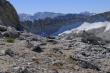
Heading down now... with the tarn below Mount Conness.
|
Conness Lakes... I'm going to go over and visit those upper lakes that I missed on the way in.
|
The Conness Lakes that I missed on the way in.
|
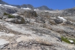
Looking down on the first Conness Lake.
|
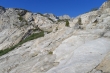
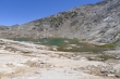
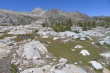
If you like walking on granite slabs, you will like this area... North Peak above.
|
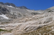
Slabs, slabs and more slabs.
|
Can't get enough of the granite slabs.
|
Almost back down to the first Conness Lake.
|
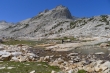
Denali Girl at the first Conness Lake... North Peak above.
|
Heading down... Saddlebag Lake and Greenstone Lake below.
|
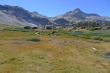
Beautiful meadow above Saddlebag Lake.
|
Back above that big waterfall we passed by earlier in the day... but we decided to go over and visit some of those lakes we saw from above in the Twenty Lakes Basin.
|
Looking back at Mount Conness as we head for the Twenty Lakes Basin.
|
We can see a few of the lakes in the Twenty Lakes Basin.
|
Denali Girl on granite.
|
On the NE side of North Peak now... looking for lakes in the Twenty Lakes Basin.
|
Still looking for those lakes in the Twenty Lakes Basin.
|
Pano shot of Cascade Lake (left), Potter Lake (center bottom), Towser Lake (center top) and Steelhead Lake (right).
|
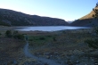
Wasco Lake as we head back toward Saddlebag and Greenstone Lakes.
|
Almost back to Saddlebag Lake and Greenstone Lake.
|
|
Pano shot of Greenstone Lake as we close the loop portion of our hike.
|
Mount Conness and North Peak as we near Saddlebag Lake.
|
Shepherd Crest (far left) and Excelsior Mountain (right center) as we near Saddlebag Lake.
|
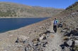
Denali Girl at Saddlebag Lake... we have decided to walk the 1.4 miles back to the resort.
|
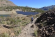
There is a dam at the south end of Saddlebag Lake, but you can't cross it... cross on the other side of the dam where there is no water... this hike was ~7.5 miles in total, gaining ~2200 feet of elevation... we would have added another 1.4 miles if we had not taken the water taxi in the morning.
|
