Cow Pies and Mitten Ridge - 4.10.2013
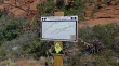
Directions to the Cow Pies Trailhead... the last 2.7 miles of the drive is on an unpaved road that requires a high clearance vehicle.
|
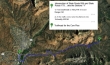
A google earth look at the terrain around Mitten Ridge... our hike was ~4 miles roundtrip, gaining ~450 feet of elevation.
|
The Cow Pies are purported to be a vortex site.
|
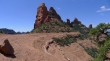
We didn't know it at the time, but the large gap on Mitten Ridge would turn out to be our high point for the day.
|
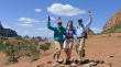
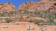
Denali Girl, BarbE and tomman are feeling the vortex.
|
We passed by the Cow Pies (we will visit them on the way back) and found the start of the Hangover Trail just below Mitten Ridge.
|
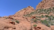
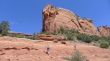
Walking west underneath Mitten Ridge on the well-cairned Hangover Trail.
|
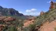
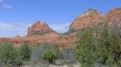
Looking west back toward Sedona.
|
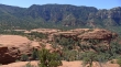
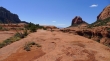
We are just below Mitten Ridge... looking across the Cow Pies to Munds Mountain.
|
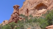
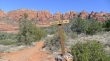
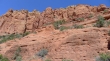
Awesome rock formations.
|
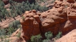
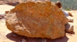
Looking down on some hamburger patties?
|
BarbE, Denali Girl and tomman look so very small.
|
Denali Girl has found one of nature's chairs.
|
Rock art.
|
The gang is heading for the large gap on Mitten Ridge.
|
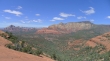
From the large gap on Mitten Ridge we can see Capitol Butte on the far left... and Wilson Mountain on the right... Midgley Bridge on Hwy 89A in the center of the photo.
|
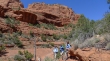
Mountain bikers on Mitten Ridge.
|
We have back tracked to visit the Cow Pies.
|
tomman and Denali Girl are dropping into the mini-canyon between the Cow Pies and Mitten Ridge.
|
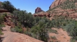
In the mini-canyon between Cow Pies and Mitten Ridge... we will use the Munds Wagon Trail to get back to our car.
|
