Devils Bridge - 4.27.2013
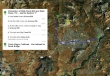
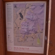
Directions to the Chuck Wagon Trailhead... the starting point for our hike to Devils Bridge.
|
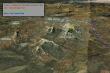
A look at the terrain around Devils Bridge... if you have a high clearance vehicle, you can drive Forest Road 152 to the Devils Bridge Trailhead... our hike was 5 miles roundtrip, gaining 600 feet of elevation.
|
We will use the Chuck Wagon Trail to get to the Devils Bridge Trailhead.
|

On the Chuck Wagon Trail... with Capitol Butte behind.
|
Lots of trail junctions along the way.
|
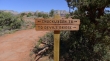
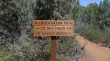
After hiking a couple miles, we have reached the Devils Bridge Trailhead.
|

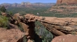
Underneath Devils Bridge.
|
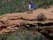
Snowdog and robman on Devils Bridge.
|

Denali Girl was on Devils Bridge also.
|
Denali Girl and ragman on Devils Bridge.
|

Continuing beyond Devils Bridge Snowdog has found a nice little aerie.
|
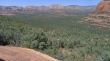
Looking north to Long Canyon and HS Canyon.
|

Snowdog making some rock art.
|
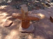
Inukshuk.
|

robman and Denali Girl coming down the rock staircase that led up to Devils Bridge.
|
