Skyline Divide - 7.23.2013
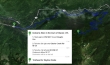
Directions from the town of Glacier, Washington to the Skyline Divide Trailhead.
|
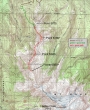
The approximate route for our hike on the Skyline Divide... ~10 miles roundtrip, gaining ~3120 feet of elevation.
|
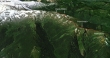
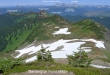
A google earth look at the terrain along the Skyline Divide.
|
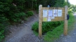
We started the hike from a large parking lot located at 4320 feet.
|
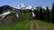
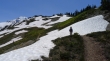
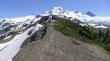
After hiking for two miles in the trees we reached the ridge at 5875 feet... pretty nice views... we will follow the ridge that runs from left to right in the middle of the photo.
|
Looking back at Point 5875 as we hike along the ridge.
|
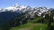
Continuing along the Skyline Divide... we will go to the bump on the far right of the photo... and then another half-mile toward Mt. Baker.
|
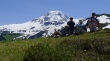
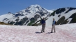
BarbE attends to a snowman... Mt. Shuksan in the distance.
|
Kicking back on the Skyline Divide... our group of 6 is now down to 4... ragman, tomman, BarbE and larman.
|
We are just north of Point 6320+ where the main path goes down hill... however, we will stay on a less traveled path that follows along the ridge to the top of Point 6320+.
|
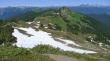
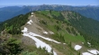
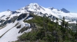
From Point 6320+ we are looking back (north) at our route along the Skyline Divide.
|
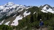
Getting closer to Mt. Baker... you can see the trail on the right side of the grassy bump in the foreground... the first of two 6560+ bumps is on the far right of the photo.
|
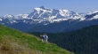
tomman and BarbE on the Skyline Divide between Point 6320+ and Point 6560+... Chowder Ridge in the center of the photo leads out to Hadley Peak on the far left... our group of 6 is now down to 3.
|
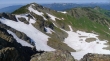
On top of the first 6560+ bump and looking back at our route along the Skyline Divide.
|
On top of the first 6560+ bump and looking over at the second 6560+ bump.
|
BarbE heading for the second 6560+ bump.
|
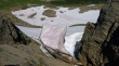
A serious moat on the east side of Skyline Divide as we get closer to Mt. Baker.
|
We are on the second 6560+ bump and looking back at our Skyline Divide route... the first 6560+ bump is on the left.
|
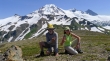
The last two standing (or sitting)... tomman waited for us on the first 6560+ bump... if time had permitted, we could have continued at least another mile along the ridge before mountaineering tools would have been required.
|
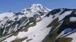
Mount Baker as we head back to the car... the second 6560+ bump is in the right foreground... Chowder Ridge in the middle of the photo running out to Hadley Peak on the far left.
|
