Nasikelt Peak - 7.30.2013
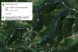
Directions from Stevens Pass to where we parked on Road 6960 for the start of our hike... 6960 goes up the Mill Creek Valley on the back side of the Stevens Pass Ski Area.
|
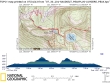
rodman's GPS track of our Nasikelt and Lumiere Ridge hike... 8.6 miles roundtrip, gaining 3027 feet of elevation.
|
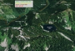
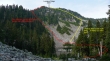
A google earth look at the terrain around Nasikelt Peak and Lumiere Ridge.
|
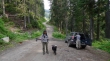
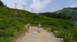
Gearing up where we parked (~4100') on Road 6960.
|
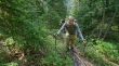
We will walk a half-mile or so on Road 6960 until we intersect with the PCT.
|
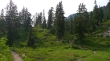
On the PCT now and heading toward Lake Susan Jane and Josephine Lake.
|
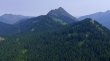
On the PCT and looking back at the back side of the Stevens Pass Ski Area... Big Chief Mountain on the far right.
|
Still on the PCT above Lake Susan Jane... later in the day we will make an attempt on Lumiere Ridge.
|
At the junction of the PCT and Icicle Creek trails... we will follow the Icicle Creek Trail for a short distance before starting the bushwhack for Nasikelt Peak.
|
We've hiked the Icicle Creek Trail for a quarter mile or so before leaving it at ~4960 feet.
|
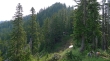
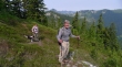
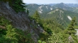
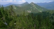
On the ridge between Nasikelt Peak and Point 5463... Nasikelt Peak in the distance.
|
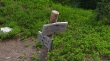
Izzy found a patch of snow... one of her favorite things.
|
Still on Nasikelt's west ridge... Point 5463 is between Snowdog and rodman... with Cowboy Mountain behind it.
|
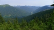
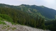
Looking down Mill Creek Valley... with Big Chief Mountain on the far left... Glacier Peak stands out in the distance.
|
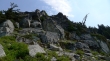
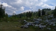
A huge rock outcropping has pushed us over to the south side of Nasikelt.
|
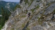
rodman on steep terrain on the south side of Nasikelt... Josephine Lake is barely visible on the far left... Lumiere Ridge is upper left.
|
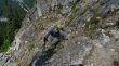
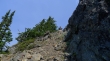
Snowdog watches rodman on what was probably the crux of the climb.
|
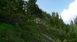
rodman is now on the north side of Nasikelt's west ridge.
|
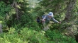
Lots of veggie belays.
|
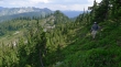
Now back on the south side of Nasikelt's west ridge... getting close to the summit now.
|
Jim Hill Mountain from the Nasikelt summit.
|
Looking north from the Nasikelt Peak summit (5863')... Cowboy Mountain on the left and Big Chief Mountain on the right.
|
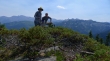
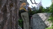
ragman and rodman on the very buggy Nasikelt summit.
|
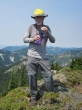
rodman took this photo of me on the summit... all of those little specks on and around me are not spots on the camera lens.
|
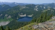
Looking down on Josephine Lake and out to Lumiere Ridge from Nasikelt Peak.
|
On the way down from the Nasikelt summit.
|
Looking back at Nasikelt... getting ready to leave the ridge and go back down to the Icicle Creek Trail.
|
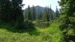
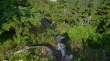
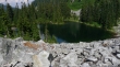
Looking over at Lumiere Ridge from a tarn above Josephine Lake.
|
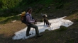
We have left the PCT at Lake Susan Jane and heading up a boulder field on the south side of the lake.
|
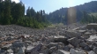
Heading up the boulder field on the south side of Lake Susan Jane.
|
Snowdog and rodman heading up the boulder field.
|
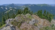
Snowdog at the top of the boulder field... with the back side of the Stevens Pass Ski Area in the distance.
|
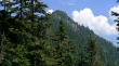
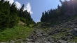
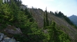
Lumiere Ridge looks pretty benign here... but it is a miserable brush bash to reach the high point.
|
Working our way along Lumiere Ridge in search of its high point.
|
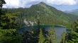
Looking at Josephine Lake, Nasikelt Peak and Jim Hill Mountain from Lumiere Ridge.
|
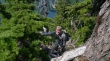
rodman on Lumiere Ridge.
|
Bushwhacking on Lumiere Ridge.
|
Lots of this kind of stuff on Lumiere Ridge.
|
Looking at the high point on Lumiere Ridge... there is a serious cliff and gully between us and the high point... and this summit will have to wait for another day... maybe.
|
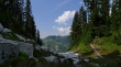
Back down to the PCT now... with a view of Josephine Lake and Nasikelt Peak... leaving a 2 mile hike to get back to the car.
|
