Central Cowlitz Chimney and Banshee Peak - 8.21.2013
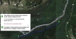
Directions from the fee station at the White River entrance of Mt. Rainier National Park to the trailhead at Fryingpan Creek.
|
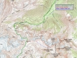
Our approximate route to Banshee Peak and Central Cowlitz Chimney... 15 miles roundtrip, gaining ~5000 feet of elevation.
|
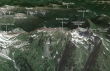
A google earth look at the terrain around Panhandle Gap and the Cowlitz Chimneys.
|
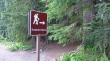
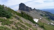
The trailhead for Summerland is directly across the road from the Fryingpan Creek parking area (3800').
|
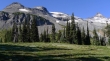
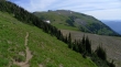
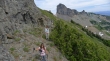
The first 3 miles of hiking are in the trees... with occasional distant views.
|
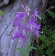
Fireweed.
|
The footbridge crossing of Fryingpan Creek after hiking 3 miles.
|
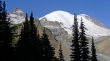
On the switchbacks leading up to Summerland... Little Tahoma and Mt. Rainier.
|
After hiking 4.2 miles we have reached Summerland... Meany Crest on the left... with Little Tahoma on the right.
|
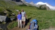
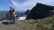
An unexpected meeting with nwhiker Zachster and her husband Mark in Summerland... they were finishing up an 11 day hike of the Wonderland Trail.
|
Beyond Summerland now and heading for Panhandle Gap.
|
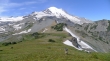
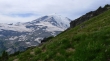
Above Summerland and looking back across the valley to the very broad Goat Island Mountain.
|
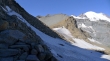
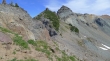
Terrain below Meany Crest.
|
A tarn above Summerland... and the first good view of Panhandle Gap on the far left.
|
A closer look at Panhandle Gap above.
|
Above the tarn... continuing toward Panhandle Gap and looking back at Meany Crest below Little Tahoma... Steamboat Prow and Mount Ruth on the right skyline.
|
The Wonderland Trail leading over to Panhandle Gap on the right.
|
Nearing Panhandle Gap.
|
One last patch of snow (upper left corner of the photo) to cross before reaching Panhandle Gap.
|
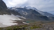
Arriving at Panhandle Gap (6800').
|
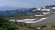
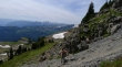
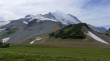
Looking north from Panhandle Gap... across the green west end of Goat Island Mountain over to Burroughs Mountain.
|
The south side of Panhandle Gap... with Mt. Adams in the distance on the left.
|
A pano shot from Panhandle Gap.
|
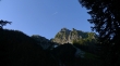
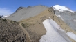
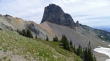
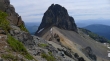
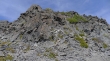
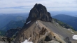
On the south side of Panhandle Gap... looks like an easy hike up to Banshee Peak (the little nipple on the ridge at the top of the photo).
|
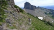
Looking back at robman on the broad open slope that will take us to Banshee Peak.
|
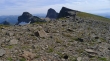
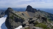
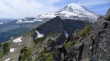
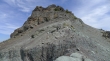
Snowdog got this shot of me pointing to Central Cowlitz Chimney on the left... with Main Cowlitz Chimney on the right... Point 7240+ is between the two chimneys in the photo.
|
BarbE, Snowdog and robman on the ridge leading to Banshee Peak... with a large snow cone in the background.
|
Banshee Peak is in the foreground on the right.
|
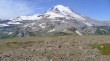
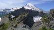
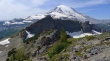
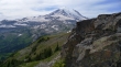
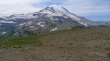
Looking back at Mount Rainier.
|
Heading for Banshee Peak on the right.
|
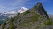
robman and Snowdog... with Central Cowlitz Chimney (distant) and Banshee Peak on the right.
|
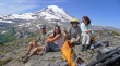
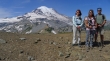
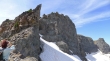
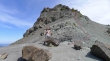
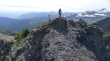
Group shot from the Banshee Peak summit (7400+).
|
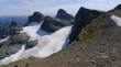
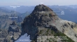
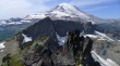
From the Banshee Peak summit... Point 7240+ is in front of Central Cowlitz Chimney... with Main Cowlitz Chimney on the right.
|
robman is heading over to find us a route over to Central Cowlitz Chimney.
|
Our approximate route to the summit of Central Cowlitz Chimney.
|
Snowdog and robman descending from Banshee Peak... we will have to give back 400 feet of elevation.
|
BarbE on the SE side of Banshee Peak... still descending.
|
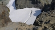
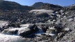
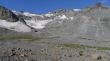
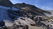
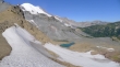
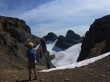
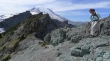
Looking down on the Sarvant Glaciers... we still need to descend.
|
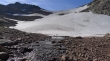
Still descending... ugh... Main Cowlitz Chimney in the distance.
|
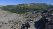
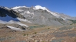
After descending 400 feet from the Banshee summit we can see the route that will get us past Point 7240+ (treed bump in the foreground) and over to Central Cowlitz Chimney.
|
BarbE checks out the east and north sides of Banshee Peak.
|
Working around the south side of Point 7240+... with Main Cowlitz Chimney in the distance.
|
The gang on the south side of Point 7240+.
|
On the south side of Point 7240+... just a little bit of up will get us over to the saddle below Central Cowlitz Chimney.
|
Snowdog on the saddle between Point 7240+ and Central Cowlitz Chimney... and the route that will get us most of the way to the top.
|
BarbE checks out the east side of Point 7240+.
|
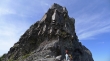
I'm ascending Central Cowlitz Chimney now... looking at Point 7240+ in front of Banshee Peak.
|
Above the light gray cliff band and looking over at Main Cowlitz Chimney.
|
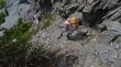
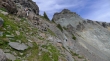
Looking down at BarbE, Snowdog and robman as they approach the light gray cliff band.
|
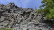
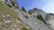
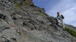
Some Class 2 work will be needed above the ramp.
|
On the bench now... it will lead us around to our right.
|
Looking down at BarbE from the bench... she is waiting for Snowdog.
|
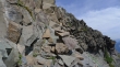
The bench led me over to a huge cairn in the center of the photo... this marks the spot to head up again.
|
On the final Class 2 section that will lead up to the summit... BarbE is still waiting for Snowdog at the very bottom of the photo.
|
Very near the summit of Central Cowlitz Chimney.
|
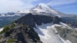
Main Cowlitz Chimney from near the Central Cowlitz Chimney summit... Mt. Adams in the distance on the right.
|
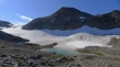
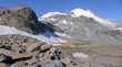
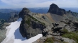
On the Central Cowlitz Chimney summit (7421') now... with the Sarvant Glaciers below Banshee Peak.
|
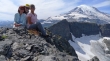
BarbE and Snowdog arrive at the summit.
|
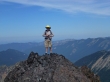
Snowdog got this shot of me on a little false summit near the true summit.
|
Group shot from the Central Cowlitz Chimney summit.
|
Heading down.
|
More down.
|
Descending the light gray cliff band.
|
BarbE is working her way over to the saddle between Central Cowlitz Chimney and Point 7240+.
|
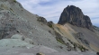
Almost back to the saddle... Main Cowlitz Chimney on the right.
|
Working our way around the south side of Point 7240+.
|
Heading for Panhandle Gap now... we have decided to try and stay a few hundred feet below Banshee Peak on our return.
|
Looking back at Main Cowlitz Chimney as we head for home.
|
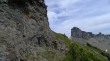
The last set of cliffs that we will have to deal with.
|
Snowdog, BarbE and robman heading for home.
|
No more cliffs... smooth sailing back to Panhandle Gap now.
|
Getting closer to Panhandle Gap... we can see the path below that will get us there.
|
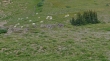
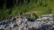
Goats.
|
On our way down from Panhandle Gap... the weather is changing.
|
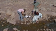
Refilling our water supply below Panhandle Gap... about 5 miles of trail hiking will get us back to our car.
|
