Mary's Peak - 11.4.2013
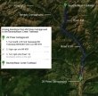
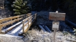
Directions from the entrance to 29 Pines Campground to the Beverly/Bean Trailhead.
|
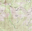
Our approximate route to the summit of Mary's Peak... using the Beverly Turnpike Trail to ~5000 feet... then contoured around and up to Mary's NW ridge (~5600')... which we followed to the summit... ~8.5 miles roundtrip, gaining 3100 feet of elevation.
|
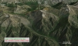
A google earth look at the terrain around Mary's Peak.
|
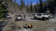
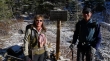
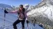
Gearing up at the trailhead (3600')... Izzy wants to know what is taking so long.
|
A dusting of snow at the Beverly Turnpike Trailhead.
|
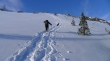
After hiking a half-mile Snowdog and robman are at the junction with the Bean Creek Trail... we will stay on the Beverly Turnpike.
|
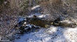
The stream crossing was very easy... unless you have trouble with slippery logs.
|
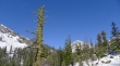
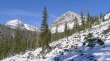
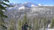
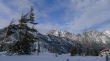
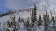
Gaining elevation on the Beverly Turnpike Trail... and a first look at Bill's Peak at the head of the valley.
|
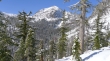
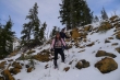
Snowdog and robman are still following the trail on 2 or 3 inches of snow... Teanaway Peak (aka Gene's Peak) on the left... with Bill's Peak on the right.
|
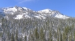
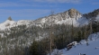
Iron Peak (right) on the west side of the valley.
|
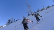
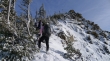
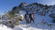
I'm looking back at robman as he comes up the Beverly Turnpike Trail.
|
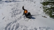
Izzy doing her stick therapy.
|
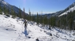
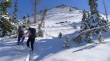
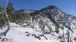
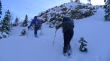
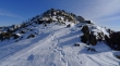
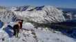
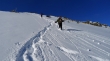
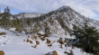
We've lost the trail and are working our way up to the NW ridge of Mary's Peak... Iron Peak across the valley.
|
Teanaway Peak as we make our way up to the NW ridge of Mary's Peak.
|
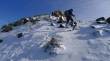
In 5 or 6 inches of snow just below the NW ridge.
|
Working hard now.
|
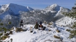
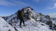
On the north side of Mary's NW ridge... with Iron Peak and Teanaway Peak in the distance... Fourth Creek Pass is below.
|
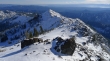
We have found a nice lunch spot (5900') on Mary's NW ridge... there is still some work to do.
|
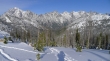
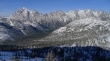
A pano shot from our lunch spot... Bill's Peak in the left foreground... Devils Head and Volcanic Neck on the far right... with the Stuart Range thru the gap.
|
Snowdog and Izzy posing for robman at our lunch spot... Iron Peak (left) and Teanaway Peak in the distance.
|
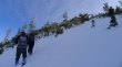
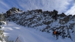
Continuing along Mary's NW ridge now.
|
Deeper snow (9 inches) on the north side of the ridge.
|
Every step higher gives a broader view of the Stuart Range.
|
The snow was more shallow on the ridge, but the terrain kept pushing us onto the north side of the ridge.
|
Back on the north side of the ridge... and deeper snow.
|
Continuing up the NW ridge.
|
Looking down Mary's NW ridge to Bill's Peak (center)... Iron, DeRoux and Teanaway on the left... with Stuart and Sherpa on the right.
|
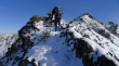
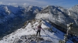
robman on the NW ridge on Mary's Peak... can we see the summit?
|
Say what?
|
robman and Snowdog can see the summit now!
|
Snowdog on Mary's NW ridge... clouds forming to the west.
|
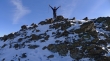
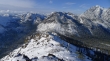
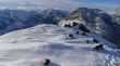
Izzy and robman on the summit (6680+).
|
Most of the Stuart Range from Mary's summit... Stuart (left), Sherpa, Argonaut, Colchuck, Dragontail and Little Annapurna.
|
A pano shot from Mary's summit... Teanaway Peak on the far left to Bean Peak (orange) on the far right.
|
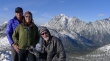
Three-quarters of the Mclees family on the Mary's Peak summit... robman, Snowdog and Isabel... with an abundance of Teanaway Peaks behind them.
|
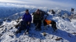
A group shot from the summit... Stuart and Sherpa in the distance.
|
Looking down Mary's NW ridge from the summit.
|
Izzy checks out Navaho Peak and Earl Peak from Mary's summit... Bean Creek Basin below.
|
Looking south along the ridge that connects to Judy's Peak.
|
Giving back elevation as we drop toward Bean Creek Basin.
|
Oops... heading back up to Mary's summit because we couldn't find a comfortable route down to Bean Creek Basin... a waste of 30 minutes... big bummer... ugh.
|
Back on Mary's NW ridge and heading down the way we came up.
|
Izzy keeping a watchful eye on her meal ticket.
|
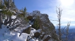
Sparkles and wind blown sculpture on Mary's NW ridge.
|
Almost back to our lunch spot.
|
Volcanic Neck (left) and Bean Peak as we descend.
|
Back to our lunch spot and looking up to Mary's summit... it took us 1.5 hours to gain the 800 feet of elevation from this spot to the summit.
|
Find Waldo.
|
Almost back to the trail.
|
It is 4:30 pm and we are still 1.5 miles from the car... we got back at 5:00 pm... and did not need to use our headlamps.
|
