Panorama Point and Mazama Ridge - 11.21.2013
|
Directions from the fee station at the Nisqually Entrance to Mt. Rainier National Park to the parking area at Paradise.
|
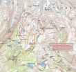
Our approximate route from the Paradise parking area to Panorama Point and our return via Mazama Ridge... ~4 miles roundtrip, gaining ~1500 feet of elevation gain.
|
A google earth look at the terrain around Paradise.
|
We parked in the large parking area between the Visitor Center and the lodge.
|
Nice views start from the parking area.
|
|
tomman, BarbE and iraman heading for Panorama Point.
|
Mt. Rainier in our face as we head for Panorama Point.
|
Continuing on our way to Panorama Point.
|
iraman and BarbE point the way to Panorama Point.
|
I found Snowdog talking with nwhiker's Hikingqueen and doublemom... if you do much hiking around Mt. Rainier, you will eventually meet Hikingqueen.
|
|
Looking across Paradise Valley to some of the Tatoosh Range... with a distant view of Mt. Adams in the center of the photo.
|
Peak identification of the Tatoosh Range and beyond.
|
The majority of people are heading for Camp Muir... but we will head for Panorama Point.
|
People on the left will head for Camp Muir... we will go up to the right.
|
Watching hikers head for Camp Muir... as we head for Panorama Point.
|
|
From Panorama Point (6800') we are looking at the Mt. Rainier on the left.
|
From Panorama Point I am looking across Unicorn Peak and Foss Peak to Mt. Adams on the horizon.
|
A pano shot of the Tatoosh Range from Panorama Point... with Goat Rocks, Mt. Adams and St. Helens on the horizon.
|
Trending east from Panorama Point... looking for the best place to give back 200 feet of elevation.
|
We found a good place to give back some elevation... steep, but workable.
|
|
Putting our snowshoes back on after giving up 200 feet of elevation.
|
A nice spot to have lunch... with views of the Tatoosh Range, Adams and St. Helens.
|
Lunch time just below Panorama Point... iraman, BarbE, tomman and Snowdog.
|
A closeup of Mt. St. Helens from our lunch spot.
|
The view from a short distance above our lunch spot.
|
|
BarbE on the move... and in the spotlight.
|
iraman and tomman are tiny specks in the center of the photo as BarbE, Snowdog and I take a slightly higher route.
|
The Tatoosh Range, Adams and St. Helens.
|
Heading down to connect with iraman and tomman.
|
A group shot in front of Mt. Rainier... BarbE, tomman, iraman, Snowdog and ragman.
|
|
BarbE, Mt. Wow, Iron Mountain, Copper Mountain, tomman, iraman and Snowdog... with Panorama Point on the right.
|
Heading down... looking for Mazama Ridge.
|
High plains drifting.
|
Snowdog and Mount Rainier... featuring the color pink.
|
Looks like a big hole... but it is more shadow than hole.
|
|
Frost bitten trees on Mazama Ridge.
|
Mount Rainier from the top of Mazama Ridge.
|
In the spotlight.
|
Continuing down... BarbE leading the way.
|
Snowdog is in the lower right corner... with Mt. Rainier and Little Tahoma above.
|
|
Snowdog crossing a bridge on the left... with tomman and BarbE... continuing down Mazama Ridge.
|
iraman... with Mt. Rainier and Little Tahoma.
|
Preparing to leave Mazama Ridge and go down to the Paradise Valley Road.
|
iraman and tomman heading down to the Paradise Valley Road.
|
Late afternoon light on Mt. Rainier.
|
|
We are on the Paradise Valley Road and heading for the Paradise parking lot.
|
On the Paradise Valley Road.
|
Nearing the Paradise parking lot.
|
The lodge at Paradise.
|
On the drive from Paradise to Longmire we stopped to get the last light of day hitting Mt. Rainier.
|


