Fortune Peak - 5.30.2014
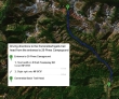
Directions from the entrance to 29 Pines Campground to the Esmeralda Basin Trailhead.
|
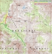
Our approximate route to Fortune Peak. ~8 miles roundtrip, gaining ~3200 feet of elevation.
|
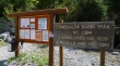
The Esmeralda Basin Trailhead (4200') is at the end of the N. Fork Teanaway River Road.
|
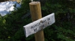
After hiking a quarter mile we found the junction for the Ingalls Way Trail... however, we will pass by this and continue up into Esmeralda Basin.
|
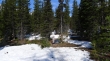
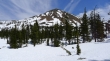
Still plenty of snow in Esmeralda Basin.
|
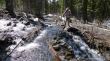
Water has taken over the trail in at least a half dozen places.
|
Tons of glacier lilies in Esmeralda Basin.
|
Did I mention that water has taken over the trail in places... Denali Girl can confirm this.
|
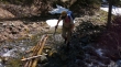
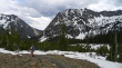
We've lost the trail now... and are just working our way up to the 6000 foot basin SW of Fortune Peak.
|
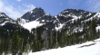
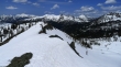
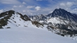
Looking over at the west summit of Esmeralda Peaks (left) as we head for the basin below Fortune Peak.
|

What does the Hawk say... win, win, win, win, win!
|
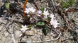
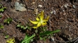
Tons of Spring Beauty wildflowers on this hike... ClaytoniaVirginica for you technical types.
|
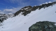
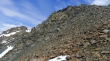
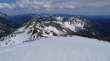
We have reached the 6000 foot basin and have a good look at Fortune Peak... we will work our way over to the ridge on the left side of the photo and then go for the summit.
|
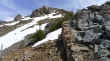
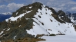
We have reached the west ridge (6500') of Fortune Peak and can see the south summit of Ingalls Peak.
|
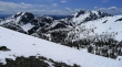
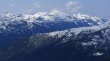
Looking south from the west ridge of Fortune... Esmeralda on the left and Hawkins on the right... with clouds sitting on top of Mt. Rainier in the center.
|
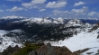
Looking west from the ridge... Scatter Peaks in the center foreground... Bears Breast, Hinman and Daniel on the left... the white pyramid on the right is Harding Mountain.
|
The Fortune Peak summit is up there somewhere... but this one is a teaser with several false summits.
|
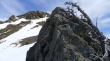
Still climbing on the west ridge of Fortune.
|
Still ascending.
|
Getting closer... South Ingalls on the left.
|
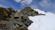
Finally I can see the Fortune Peak summit.
|
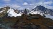
On the summit (7382')... Ingalls Lake in the center of the photo is just starting to melt... South Ingalls Peak on the left and Mt. Stuart on the right... looking across Stuart Pass to Jack Ridge in the center... with Cashmere Mountain beyond.
|
Scatter Peaks, The Cradle, Solomon and Harding in the center... Hinman and Daniel on the left... and I believe the Chiwaukum Mountains are on the right.
|
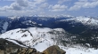
Some of the Teanaway Peaks from the Fortune Peak summit... Point 6878 is in the foreground... follow the ridge over past Longs Pass to Teanaway Peak and Iron Peak on the right... Three Brothers and Navaho Peak on the left... with Bill Peak and Earl Peak in the center.
|
South Ingalls and East Ingalls from Fortune... with Cashmere Mountain in the distance on the far right.
|
The West summit of Esmeralda on the left and Hawkins on the right... with Mt. Rainier on the horizon in the center.
|
Relaxing on the Fortune Peak summit... soaking up the awesome views.
|
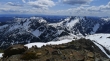
Looking into the heart of the Alpine Lakes Wilderness from Fortune Peak.
|
A closeup of Mt. Hinman and Mt. Daniel in the center... with Bears Breast Mountain on the far left.
|
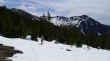
Heading back to the car... with the East summit of Esmeralda Peaks on the right.
|
