Cutthroat Lake - 6.5.2014
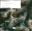
Directions from Rainy Pass on Hwy 20 to the Cutthroat Lake Trailhead.
|
The Cutthroat Lake Trailhead (~4540') is a one mile drive on paved road from Hwy 20... the hike is 3.3 miles roundtrip, gaining 400 feet of elevation.
|
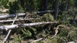
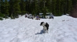
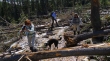
About a mile into the hike there is a 50 yard swath of avalanche debris... you can barely see Denali Girl as she works her way through the debris at the beginning of the debris field.
|
Looking across the avalanche debris field to Cutthroat Peak.
|
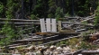
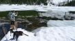
A foot bridge in the avalanche debris field... Mother Nature usually wins.
|
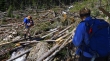
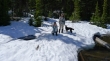
robman and Denali Girl crossing the avalanche debris field.
|
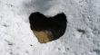
Awwww... and it isn't even Valentine's Day.
|
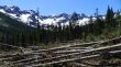
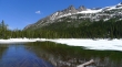
A pano shot of Cutthroat Lake (4935') below Cutthroat Peak (8050').
|
Unnamed bumps above Cutthroat Lake.
|
Lunchtime at Cutthroat Lake... Izzy is on patrol.
|
Artist at work.
|
Hey now... who is shooting who here.
|
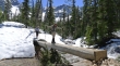
Denali Girl and Snowdog crossing Cutthroat Creek on the way back to the car... look ma, no hands.
|
Recrossing the avalanche debris field... we are basically on what used to be the trail.
|

We drove to Winthrop after the hike so that Snowdog and BarbE could ride the bulls.
|
