Tinkham Peak and Silver Peak - 7.16.2014
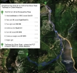
Directions from Exit 52 at Snoqualmie Pass to the PCT in Olallie Meadow (3800')... where we started our trip.
|
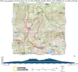
rodman's GPS track for our trip to Tinkham Peak and Silver Peak... 6.5 miles roundtrip, gaining 2766 feet of elevation.
|
We started from where the PCT crosses FS 9070 in Olallie Meadow (3800').
|
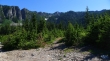
After hiking ~2 miles on the PCT, we left the PCT on a good path (~4320') that was easy to find because of these two large cairns.
|
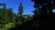
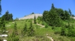
We've reached the saddle (4800') between Tinkham Peak and Silver Peak... Silver Peak is in the distance.
|
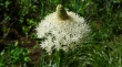
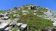
Lots of beargrass on this hike today.
|

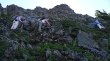
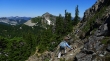
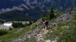
We have left the Tinkham/Silver saddle and heading toward Tinkham Peak on a good path.
|
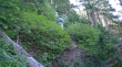
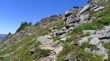
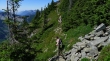
The path to Tinkham Peak follows along part of the Cedar River Watershed.
|
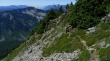
The path leading to Tinkham is much steeper than it looks in this photo.
|
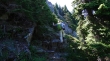
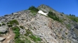
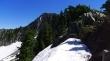
rodman getting ready to come out of the trees below the south face of Tinkham Peak.
|
The path crosses underneath the south face of Tinkham.
|
I'm almost on the summit... the path to the summit is in the shade of the photo... Silver Peak is in the left foreground... Kaleetan Peak and Chair Peak in the distance.
|
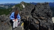
BarbE signs the register on the Tinkham Peak summit (5398')... Silver Peak is behind her.
|
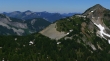
Silver Peak in the left foreground... with Mt. Catherine in the right foreground... with Snoqualmie Pass Peaks and Dutch Miller Peaks beyond.
|
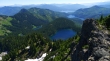
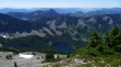
Mirror Lake is closest... with Cottonwood Lake to the left... with Lost Lake and Keechelus Lake beyond.
|
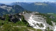
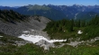
Looking down on the Tinkham Tarns from the Tinkham summit.
|

We got this group shot on the east peak of Tinkham Peak... three feet lower than the true summit behind us. It was only a 10 minute walk from the true summit.
|
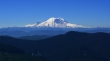
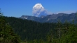
Mount Rainier from Tinkham Peak.
|
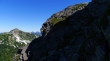
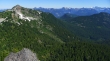
From Tinkham Peak we could see the trail switchbacking its way up to Silver Peak on the right... Humpback Mountain is in the left foreground.
|
Working our way down from the Tinkham summit... with Silver Peak in the distance.
|
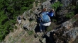
A few Class 3 moves to get off of the Tinkham summit block.
|
Back to the Silver/Tinkham saddle... and heading for Silver Peak in the distance.
|
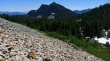
Getting ready to head up the talus field on Silver Peak.
|
Gaining elevation on the talus field on the south side of Silver Peak... and looking back at the twin summits of Tinkham Peak.
|
Heading for the Silver Peak summit on good trail.
|
Almost on the Silver Peak summit.
|
Just a stroll now to reach the summit (5605').
|
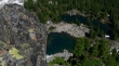
Looking down on Annette Lake from the Silver Peak summit.
|
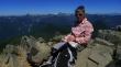
Whoa... someone has a new shirt.
|

Looking down on Olallie Meadow from the Silver Peak summit... our car is parked down there... Mt. Catherine in the right foreground.
|
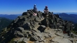
Snowdog, BarbE and rodman resting on the Silver Peak summit.
|
From the Silver Peak summit we will follow a good path on the west side of Silver's NW ridge... to where it comes back over to the east side of the ridge... then use the snow as long as we can to get down to Olallie Meadow.
|
Leaving the Silver Peak summit on a good path... Annette Lake below.
|
Working our way along the west side of Silver's NW ridge... following a good path.
|
Still on the west side of Silver's NW ridge.
|
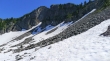
We have come back over to the east side of Silver's NW ridge... looking up at the north face of Silver Peak.
|
Snowdog starts down from Silver's NW ridge toward the snowfield below.
|
BarbE and rodman almost down to the snowfield on the north side of Silver Peak.
|
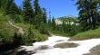
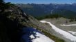
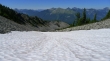
The snowfield on the north side of Silver Peak... Granite Mountain and Kaleetan Peak on the horizon.
|
Looking back at the north face of Silver Peak.
|
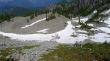
Continuing down the snowfield on Silver's north side... Granite Mountain is in the center of the photo... with Kaleetan, Chair, Bryant, The Tooth and Denny just to the right of Granite... Snoqualmie Mountain on the far right.
|
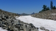
We have run out of snow and can see part of the path below that will get us down to Olallie Meadow.
|
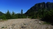
We have reached the road system in Olallie Meadow.
|
Looking at Silver Peak from the road system in Olallie Meadow... we will have about a mile road walk back to our car.
|
From Olallie Meadow we can see the smoke from the Chiwaukum Fire near Leavenworth, Washington... it is at least 50 miles away.
|
