Nimbus Mountain and Thor Peak - 9.15.2014
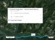
Directions from the Skykomish Ranger Station to the Tunnel Creek Trailhead.
|
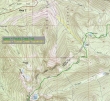
The first 5 miles of the hike was on good trail... parking at 3000 feet and hiking the first 1.5 miles on the Tunnel Creek Trail to Hope Lake (4400')... then 3.5 miles on the PCT to Trap Pass (5800').
|
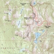
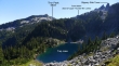
Our 1.5 mile approximate route from Trap Pass (5800') to our campsite at Upper Thunder Mountain Lakes (6400')... with side trips to Nimbus Mountain and Thor Peak.
|
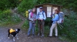
We parked at 3000 feet... starting at the Tunnel Creek Trailhead.
|
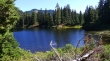
After hiking 1.5 miles on the Tunnel Creek Trail we reached Hope Lake (4400').
|
At Hope Lake we will head south on the Pacific Crest Trail to Trap Pass.
|
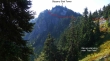
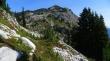
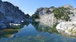
We are above Trap Lake and very near Trap Pass.
|
At Trap Pass we will leave the PCT and head for Thunder Mountain Lakes. A good boot path will lead us up toward Slippery Slab Tower.
|
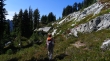
We have just left the PCT at Trap Pass... and are on the good boot path above Trap Lake that will lead us up to Slippery Slab Tower.
|
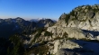
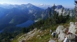
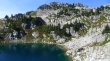
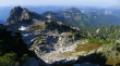
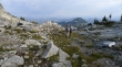
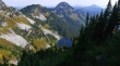
Looking down on Trap Lake as we work our way up toward Slippery Slab Tower... K9 and Jim Hill Mountain are in the center of the photo... Big Chiwaukum is on the far right.
|
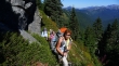
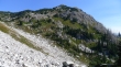
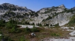
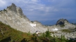
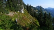
BarbE, Snowdog and Izzy are out of the trees (~6000')... with Slippery Slab Tower behind.
|
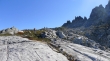
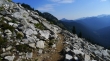
We are on a good path... and will follow it along the east side of Slippery Slab Tower.
|
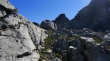
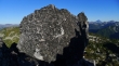
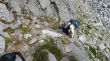
tomman is on the east side of Slippery Slab Tower... and when the path is covered with rock, we followed cairns like the one in the lower right corner of the photo.
|
BarbE heading for Thunder Mountain Lakes... awesome rock formations on the right.
|
We can see part of the PCT cutting across the meadow on the side of K9... Glacier Peak in the distance on the left.
|
tomman... with Glacier Peak and K9 behind.
|
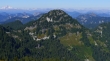
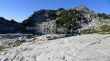
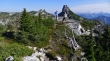
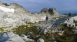
Seeing Nimbus Peak means we are getting close to Thunder Mountain Lakes.
|
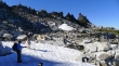
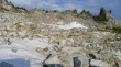
The only snow we saw.
|
We are dropping 100 feet to the Upper Thunder Mountain Lake... snow covered Mt. Daniel and Mt. Hinman are in the distance on the left.
|
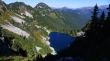
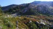
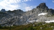
Looking down on Lower Thunder Mountain Lake... Mac Peak on the right... with Mt. Stuart and the Stuart Range on the far left... The Cradle, Granite Mtn and many others are in the center.
|
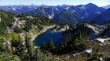
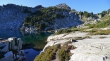
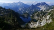
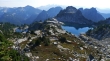
Scouting out Upper Thunder Mountain Lake for our campsites... Nimbus Mountain is above.
|
Mt. Stuart and The Cradle from Upper Thunder Mountain Lake.
|
Nimbus Mountain from our campsite... we will take the short hike up to the summit before dinner.
|
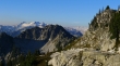
Looking east and SE from the summit of Nimbus Mountain... part of the Chiwaukum Range is on the horizon on the left... with the Stuart Range on the right... Thor Peak is in the center of the photo... not the pointy thing.
|
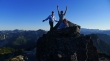
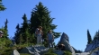
tomman, Snowdog and BarbE on the 'dog head' next to the fin on Nimbus Mountain.
|
tomman, Snowdog and ragman on Nimbus Mountain.
|
The fin is the true summit (6711') of Nimbus Mountain... but if you stand on the 'dog head' you will be higher than the top of the fin.
|
Looking down on Upper Thunder Mountain Lake from the summit of Nimbus Mountain.
|

Back at our campsite... Snowdog and Izzy are glowing in the alpenglow.
|
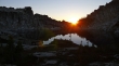
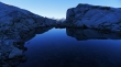
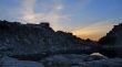
Sunset at Thunder Mountain Lakes.
|
My campsite at Upper Thunder Mountain Lake.
|
Mac Peak (left) and snow-covered Mt. Daniel and Mt. Hinman from camp.
|
Looking across Point 6594 to Mt. Daniel (left) and Mt. Hinman.
|
Looking down at the lower lake... Mac Peak is in the center of the photo... with Point 6594 on the right.
|
We have left our campsite and will day hike to Thor Peak.
|
Izzy finds time to swim in a tarn on our way to Thor Peak... Mt. Daniel in the distance.
|
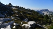
Working our way down toward Squar Lake... we are a little high here... and need to be on that bench a 100 feet below.
|
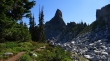
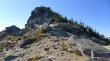
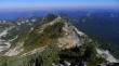
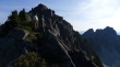
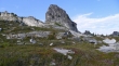
Our first good look at Thor Peak... we will traverse across the boulders to the saddle above on the left.
|
Our approximate route to the Thor Peak summit from the saddle between Thor and the ridge east of Thunder Mtn Lakes.
|
BarbE and tomman just below the Thor Peak summit.
|
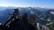
Looking west and NW from the summit of Thor Peak.
|
Looking north from the Thor Peak summit... Glacier Peak is trying to reach above the haze.
|
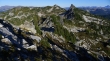
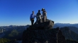
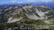
ragman on the summit (6804') of Thor Peak... Square Lake below... Granite Mtn on the left... with Daniel and Hinman on the right.
|
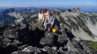
tomman, BarbE, Snowdog and Izzy on the Thor Peak summit... Nimbus Mountain on the right.
|
Back down to the saddle between Thor Peak and the ridge east of Thunder Mountain Lakes... crossing the boulder field on our way to the shelf that lead us around to the lakes... Mac Peak and Mt. Daniel in the center of the photo.
|
Past the boulder field now and on the shelf that will lead to the lakes... looking back at Thor Peak.
|
Just follow the shelf.
|
Looking down on the Lower Thunder Mountain Lake... now we will start gaining some elevation to find a good spot to cross over to the upper lake.
|
Working our way over and up to the Upper Thunder Mountain Lake... which sits on the bench running across the middle of the photo... Nimbus Mountain on the right.
|
tomman doing a little Class 2 climbing on the way back to Upper Thunder Mountain Lake.
|
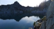
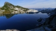
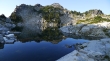
Back at Upper Thunder Mountain Lake... nice reflections... Nimbus Mtn on the right.
|
Before dinner we decided to go up to Point 6680+ due east of the upper lake... Thor Peak is left-center on the horizon... Mt. Stuart and The Cradle stand out on the right.
|
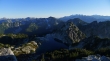
Looking down on Thunder Mountain Lakes from Point 6680+.
|
Looking north from Point 6680+... Slippery Slab Tower is in the center of the 3 rock outcroppings on the left... K9 in the center of the photo.
|
Back down at the upper lake... we decided to circumnavigate the lake... tomman leads the way.
|
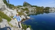
BarbE circumnavigating Upper Thunder Mountain Lake.
|
Still circumnavigating the upper lake.
|
Still circumnavigating the upper lake.
|
Our high point as we circumnavigate the lake... Thunder Mountain on the far right.
|
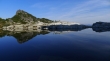
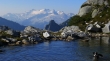
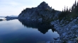
Nice reflections as we circumnavigate the upper lake... our campsite is across the lake.
|
tomman and BarbE enjoy the reflections.
|
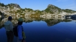
At the south end of the upper lake... with Nimbus Mountain in the center of the photo.
|
Sunset is coming... my tent in the lower left corner.
|
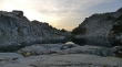
Sunset at Upper Thunder Mountain Lake.
|
BarbE and tomman on the bench above... with a red sky over Mt. Daniel.
|
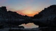
Sunset reflecting on the lake.
|
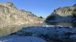
Morning dawns... with pink clouds on the lower lake.
|
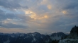
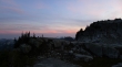
Looks like it might be a cloudy day.
|
Goodbye to Thunder Mountain Lakes... time to start the 6.5 mile hike back to the car.
|
tomman is on the way to the car.
|
Heading out.
|
Back across the only snow we stepped on the entire trip.
|
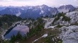
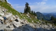
Looking back at Nimbus Mountain (right) as we continue down.
|
Heading in the direction of K9.
|
Still descending.
|
Still descending... K9 in the center of the photo.
|
tomman and BarbE crossing underneath Slippery Slab Tower.
|
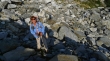
Someone is having fun!!!!
|
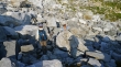
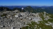
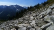
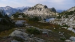
Will the boulders ever end?
|
Finally done with the boulders... and back in the trees.
|
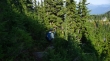
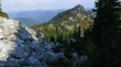
On a good path in the trees that will lead us down to Trap Pass.
|
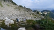
We can see Trap Lake as we work our way over to Trap Pass... K9 in the center of the photo.
|
tomman and BarbE are less than a minute from Trap Pass.
|
Finally back on the PCT... still 5 miles from the car.
|
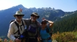
We ran into nwhikers 'modern', 'b00' and Petra while we were hiking the PCT underneath K9... Nimbus Mountain is the flatish one in the center of the photo... Slippery Slab Tower is the monolith on the right.
|
