Green Mountain Lookout - 11.7.2014
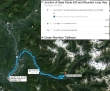
Directions from the junction of Mountain Loop Hwy and State Route 530 to the Green Mountain Trailhead.
|
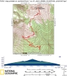
rodman's GPS route of our trip to Green Mountain Lookout... 8.25 miles roundtrip, gaining 3278 feet of elevation.
|
After you have driven 5.7 miles (at `3500') on the Green Mountain Road, look for this sign on the left side of the road. Parking is on the right side of the road.
|
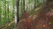
The first 3 miles of the trail are nicely graded and in excellent condition.
|

Bearded trees.
|
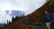
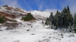
After hiking a couple of miles we were on a large, open slope.
|
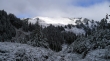
Our first look at the Green Mountain summit. The lookout can be seen from this spot, but is in the clouds now.
|
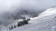
Less than a half-mile from the summit now... looking down at the basin we crossed on our way up to the lookout... several folks are on the trail below.
|
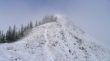
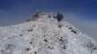
The lookout is up there somewhere.
|
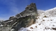
Nice rock formation near the summit.
|
rodman is just below the summit.
|
The deck on the east side of the lookout needs some repair.
|
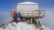
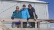
rodman is with Don Beavon and his dog Buster at the Green Mountain Lookout (6500').
|
Don Beavon got this shot of us on the summit... rodman, Denali Girl and ragman.
|
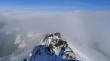
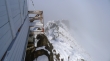
Looking north from the Green Mountain Lookout... the clouds are blocking some of the best mountain views in the world.
|

Looking down at the basin we crossed on our way up to the lookout.
|
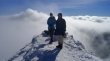
Denali Girl and rodman on the Green Mountain summit... surrounded by clouds.
|
Looking back up at Green Mountain as we hike back to the car. Looks like we may have left 30 minutes too soon... arg!
|
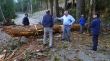
On our drive back on the Suiattle River Road we found this down tree blocking our progress.
|
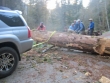
Thank goodness rodman had a tow strap in his car that saved the day.
|
