Bandera Mountain - 1.8.2015
|
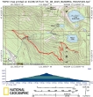
Directions from Exit 45 on I-90 to the Mason Lake Trailhead. "
|
rodman's GPS track for our trip... 7 miles roundtrip, gaining 3212 feet of elevation."
|
We parked at the trailhead and decided that we would walk back down the road for a few hundred feet and take a shortcut."
|
We left the road a few hundred feet back down the road from the parking lot. This is not an official trail... and the path is very faint. This shortcut might save a half-mile of hiking, but in my opinion, the bushwhack is not worth it."
|
The crux of the trip was getting across Mason Creek. It kind of looks like Izzy is thinking about about her food in Snowdog's pack."
|
|
Continuing up the Mason Lake/Ira Spring Trail... in open terrain now... looking west to a fogged-in Puget Sound... with Web Mountain and Mt. Defiance above."
|
We have reached the junction of the Mason Lake and Bandera Mountain Trails. It is so windy that we decided to continue on up to the Ira Spring Memorial Plaque... and then stay in the trees to reach the Mason Lake overlook."
|
The Ira Spring Memorial Plaque."
|
Bird whisperer... we are at the Ira Spring Memorial Plaque and the boundary (sign on tree) to the Alpine Lakes Wilderness... this is where we will leave the trail and follow a good path through the trees up to the Mason Lake overlook."
|
We have come out of the trees and joined the Bandera Mountain Trail just below the Mason Lake overlook."
|
|
Snowdog is ascending the west ridge of Bandera's false summit."
|
Almost on Bandera's false summit... and a nice view of the Snoqualmie Pass peaks."
|
Looking west to a fog covered Puget Sound and on out to the Olympic Mountains on the horizon... Mason Lake is below... with Web Mountain and Mount Defiance above."
|
Snowdog has found a nice perch just below Bandera's false summit... and out of the wind."
|
Four 12's on the false summit of Bandera Mountain... with Mount Rainier in the distance... Go Hawks!"
|


