Bryant Peak - 7.29.2015
|
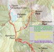
A photo of the GPS track of our trip to Bryant Peak and Melakwa Lake... 11.2 miles roundtrip, gaining 4149 feet of elevation... save a couple miles of hiking and ~300 feet of elevation gain by skipping the side trip to the lake.
|
A closer look at the GPS track from Hemlock Pass to the Bryant summit... we determined that the best route is to stay on the ridge at Hemlock Pass and not drop to the west side of the pass.
|
robman checks out the trailhead information board for the Denny Creek Trailhead.
|
A half-mile or so into the hike we passed underneath I-90.
|
Crossing Denny Creek at the bathing rocks after hiking one mile.
|
|
The trail passes by Keekwulee Falls... not much water today.
|
In the upper basin... the trail will switchback its way up to Hemlock Pass in the center of the photo.
|
We continued past Hemlock Pass for 50 yards... and have now left the trail at the first boulder field we found on the west side of the pass.
|
Working our way up to the ridge that connects Hemlock Pass to the SW side of Bryant Peak.
|
Almost back to the ridge that connects Hemlock Pass to the the SW ridge of Bryant Peak.
|
|
At ~4800 feet we reached a small meadow on Bryant's SW ridge. There is a good sized cairn on this huge boulder, but don't be suckered into going to the hikers left here... continue a short distance further down toward Denny Creek.
|
A short distance from the huge boulder in the previous photo we found another cairn that shows the place to head up.
|
Yes we are on a faint path.
|
The faint path is steep in places... here rodman uses a tree root and branch stub to help with the ascent.
|
Still on the brushy path between 4800 feet and 5000 feet.
|
|
At ~5000 feet we are out of the brush and can see some boulders up ahead.
|
Snowdog has found a path on the SW ridge of Bryant Peak.
|
robman coming up the large boulder field on the SW ridge of Bryant Peak.
|
Still on a reasonable path as we ascend the SW ridge of Bryant Peak.
|
A few more boulders on the SW ridge of Bryant Peak... McClellan Butte and Mount Defiance in the distance on the left.
|
|
High enough now to see Mt. Rainier to the south.
|
We have reached the summit block of Bryant Peak... the route that Snowdog and BarbE have chosen probably goes... but rodman and the rest of us are choosing the route that we know will go.
|
robman and rodman are above the band of trees that we followed up to the summit.
|
Snowdog is at the top of the band of trees that led us up to the summit.
|
Looking down on Melakwa Lake and Upper Melakwa Lake from the summit (5801') of Bryant Peak.
|
|
Kaleetan Peak (left) and Chair Peak from Bryant Peak.
|
Lots of peaks to look at from the summit of Bryant Peak.
|
Melakwa Lake below... looking out to Bandera Mountain and Pratt Mountain in the left center of the photo... with McClellan Butte and Mt. Defiance in the center of the photo... Kaleetan South Peak is in the right foreground above Upper Melakwa Lake.
|
Looking at the old and new trails for Snow Lake.
|
Group shot on the Bryant Peak summit... BarbE, rodman, ragman, Snowdog and robman... Kaleetan Peak on the far left... and Chair Peak behind us.
|
|
The gang heads out to the west end of the Bryant Peak summit area... with Kaleetan Peak and Chair Peak on the right.
|
Snowdog heads down the band of trees as she leaves the summit.
|
BarbE looks at a big step as she descends.
|
BarbE watches rodman and robman coming down from the summit.
|
A fun scramble on the SW ridge of Bryant Peak.
|
|
Off of the summit block and on easier terrain... still steep, but easier.
|
As we descend we are looking over at Hemlock Peak and the notch between Bryant Peak and Hemlock Peak in the middle of the photo.
|
Oh fun... back to the steep brushy part of the path between 4800 feet and 5000 feet.
|
From Hemlock Pass we decided to go over to Melakwa Lake for a swim... the south ridge of Chair Peak on the left... with Bryant Peak on the right.
|
I went on up to Upper Melakwa Lake... looking up to Melakwa Pass... with Kaleetan Peak on the left side of the pass... from here it will be at least a 4.5 mile hike back to the car.
|


