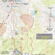
South Sister - 8.6.2015
|
A photo of the GPS track for my trip to the summit of South Sister... starting at Devils Lake and coming down via the Green Lakes Trail... 14.6 miles roundtrip, gaining 5383 feet of elevation. If you can't get a ride back to Devils Lake, you will need to hike 2 miles along the Cascade Lakes Highway to get back to your car.
|
The Climber's Trail for South Sister is located near the restroom at Devils Lake... I started at 5 a.m. in a 32 degree temperature.
|
After gaining ~1500 feet of elevation in ~1.75 miles I got my first look at South Sister.
|
The next mile of hiking is on fairly flat terrain as I hiked above Moraine Lake... looking over at Broken Top blocking the sunrise.
|
The sun is starting to hit South Sister.
|
|
Here comes the sun... above Broken Top.
|
Looking back as the sun hits the flat portion of the hike... with Mt. Bachelor in the distance on the left.
|
South Sister with sunshine on the top.
|
Nearing the tarn at 8800 feet.
|
The tarn at 8800 feet... can't see the summit of South Sister from here... but I can see the crater rim at 10,200 feet.
|
|
Looking back at my route from the tarn at 8800 feet... the mile of flat terrain above Moraine Lake is in the right-center foreground of the photo... with Mt. Bachelor in the left-center.
|
Continuing above the 8800 foot tarn... with Broken Top on the left... and Mt. Bachelor on the right.
|
Still ascending toward the crater rim... with the Lewis Glacier on my right.
|
Gaining elevation and looking back at my route.
|
Still ascending.
|
|
Just a few more steps will get me to the crater rim.
|
At the crater rim (10,200')... looking at the summit across the snow... but I will go to the right and follow a good path over to the summit.
|
A pano shot from the crater rim... with Broken Top and Green Lakes on the left... Mt. Bachelor in the center of the photo.
|
Continuing around the rim on a good path... with the summit on the left.
|
Approaching the summit.
|
|
North Sister comes into view... and some of the Chambers Lakes.
|
On the summit... looking at the snow in the crater rim.
|
Summit (10,358') selfie... with Middle Sister and North Sister.
|
Middle Sister and North Sister in the foreground... with Mt. Washington, Mt. Jefferson and Mt. Hood beyond... Chambers Lakes below.
|
A pano shot that includes Carver Lake on the far right.
|
|
A slightly different angle of Middle Sister and North Sister as I continue along the path that goes all along the crater rim.
|
Looking across the crater rim to Mt. Bachelor.
|
Looking NW from the crater rim to 'The Husband' in the center of the photo.
|
Continuing around the rim... looking back to the north.
|
Time to head back down to the tarn.
|
|
Back at the 8800 foot tarn... where I have decided to follow the path along the east side of the tarn and go down to Green Lakes.
|
Heading for Green Lakes on a nicely cairned path... Broken Top in the distance.
|
Looking back at my route from the tarn.
|
Lots of work to do in order to get down to Green Lakes... there are two obvious cairns in the foreground of the photo.
|
Looking back at the gnarly terrain that leads from the tarn to Green Lakes.
|
|
From the 8800 foot tarn it is necessary to lose 2300 feet of elevation to reach Green Lakes.
|
Almost at Green Lakes... looking back at my route.
|
Reaching Green Lakes (6505')... with Broken Top above.
|
Looking back at my route down to Green Lakes.
|
The largest of the three Green Lakes.
|
|
Nice to be on a good trail again... looking back at South Sister.
|
I am heading for the Green Lakes Trailhead.
|
The Green Lakes Trail will follow along Fall Creek.
|
Lots of beautiful falls on Fall Creek.
|
I have reached the Green Lakes Trailhead... now it is time to find a ride back to my car at Devils Lake... which will save a 2 mile hike on the Cascade Lakes Highway.
|


