The Maze and Big Pine - 1.30.2021
|
We started this thru-hike at 'The Maze'... but had to park in a paved pull-out... located along Park Boulevard... a half-mile SE from the official trailhead... we will cross the road and head for the lower gap in the center of the photo... just above the driver's door (white car) in the photo.
|
Heading up to the gap shown in the previous photo... entering the SE corner of 'The Maze'.
|
I'm at the gap in the SE corner of 'The Maze'... looking back at the route we used to get here from where we parked along Park Boulevard... Quail Mountain (the high point in the park) is above Denali Girl's head... with Mt. Minerva Hoyt above Star Dancer's head in the photo.
|
From the gap we will continue in 'The Maze'... hiking NE for the gap on the far right of the photo... look closely and you will see a section of the snow covered San Bernardino Mountains on the far left horizon in the photo.
|
A close-up of the San Bernardino Mountains in the previous photo... with the high point (11,503 feet) being San Gorgonio Mountain on the far left... the high point in southern California.
|
|
After hiking a total of 1.1 miles we have joined the 'Maze Loop Trail' in the eastern section of 'The Maze'.
|
After hiking 1.6 miles we have left the 'Maze Loop Trail' and now hiking NE on the 'North View Trail' which is also a trail in 'The Maze'.
|
After hiking 1.8 miles we will leave the 'North View Trail' and head NE on the 'Big Pine Trail'... in search of the big pine.
|
After hiking 2.5 miles we will head north for the big pine.
|
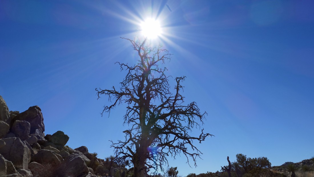
Heading for the big pine... looks like a very large tree out there in the gap.
|
|
After hiking 3.1 miles we have found the big pine... but let's continue a short distance beyond the tree and see what is out there in the distance.
|
Looking north from the big pine... with the Bullion Mountains on the horizon... with most of the flatish terrain being a 'Marine Corps Air Ground Combat Center'... the largest United States Marine Corps Base.
|
Returning from our view of the Bullion Mountains and the Marine Corps Base... now heading south to rejoin the 'Big Pine Trail' which will take us over toward the Boy Scout Trail.
|
Hiking cross country for a while in search of the 'Big Pine Trail'... looking through the gap in the center of the photo at Queen Mountain on the horizon.
|
After hiking 3.6 miles we have rejoined the 'Big Pine Trail'... now hiking SE... with Keys Peak in the right center foreground.
|
|
Hiking through a field of quartz on the 'Big Pine Trail'... as we continue SE toward Keys Peak in the distance.
|
After hiking 4.4 miles we decided to leave the 'Big Pine Trail' and head cross country before reaching the 'Boy Scout Trail'... a hiker we met on the 'Big Pine Trail' told us that the 'Boy Scout Trail' was really crowded... so we decided to avoid the crowds.
|
The Nolina Cactus in the previous photo caught my attention... so I decided to take a closer look... actually the rock formation in the gap above caught my attention just as much as the cactus.
|
Now hiking cross country to the south... paralleling the 'Boy Scout Trail'.
|
Continuing to hike south as we parallel the 'Boy Scout Trail'... here looking east beyond the 'Wonderland of Rocks' to Queen Mountain in the center of the photo... with Ellsmere Island (a popular rock climbing area) in the right center foreground of the photo.
|
|
After hiking 7 miles we are looking over at Ellsmere Island on the left... we will continue to hike south as we parallel the 'Boy Scout Trail'.
|
Continuing to hike south as we parallel the 'Boy Scout Trail'... here we are on a climber's access trail and have just passed by 'Brownie Girl Dome' back there on the left.
|
After hiking 7.9 miles we have joined the 'Boy Scout Trail'... almost back to our other car.
|
After hiking 8.25 miles we have arrived at the trailhead for the 'Boy Scout Trail'... where we parked one of our cars before we started the thru-hike back at 'The Maze' earlier in the day... the thru-hike was 8.25 miles, gaining 675 feet of elevation.
|

This photo was taken two hours after we finished our hike in Joshua Tree National Park... we had stopped to make a left turn and were rear-ended by a car doing 55-60 MPH... long story short... we are just happy to be alive... and hope to be able to do more hiking in the future.
|
