Scatter Peak - 9.28.2008
|
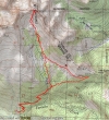
We drove incredibly rough roads 4W301 and 4W302 for a total of 2.3 miles... then parked and walked 4W302 for .5 miles to trail #1339... eventually connecting with and hiking the County Line Trail #1226.2 for ~1 mile... then cross country to the summit.
|
Shortly after leaving the County Line Trail we arrived at this boulder field.
|
Hiking along the edge of the boulder field up towards the 6200' basin south of the Scatter Peak summit.
|
Janet, Charlie, Denali Girl, and rodman relaxing in the 6200' basin.
|
Charlie and rodman start the climb up towards the Scatter Peak summit.
|
|
Charlie doing some Class 3 climbing two bumps left of the Scatter Peak summit.
|
ragman doing some Class 3 climbing... but not as graceful as Charlie.
|
ragman and Charlie on the Scatter Peak summit (7031').
|
rodman nears the Scatter Peak summit... Mt. Daniel in the distance.
|
Charlie signs the summit register while ragman fiddles with his camera... Mt. Stuart in the distance.
|
|
The summit register was placed on 11/3/2007 by Smit and Collins.
|
The Cradle, Glacier Peak, Solomon (a.k.a Fish Eagle) Peak, and Harding Mtn.
|
A closeup of Mt. Daniel.
|
A closeup of Mt. Stuart.
|
Mt. Stuart, Ingalls Peak, and Fortune Peak.
|
|
Looking north from Scatter Peak... Tucquala Peak, Sherpani Peak, and the two summits of Granite Mtn.
|
A closeup of The Cradle and Nursery Peak.
|
The Scatter Peak summit is on the right.
|
The 6200' basin south of Scatter Peak... South Ingalls Peak, Fortune Peak, Esmerelda Peaks, and Hawkins Mtn.
|
Group photo in the 6200' basin... Denali Girl, Charlie, Janet, ragman, and rodman.
|


