Mac Peak - 9.12.2012
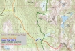
The big picture... using the Foss River Road #68 and FS 6830 to reach the start (3640') for the Deception Creek Cutoff trail #1059.1... then using trails #1059 and #1059.2 to reach the PCT... where we headed south for about 30 steps before heading cross country for Mac Peak.
|
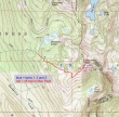
A closer look at the approximate cross country portion of the trip to Mac Peak. Considering the number of ups and downs on this trip, the hike was ~10.5 miles roundtrip, gaining ~4500 feet of elevation.
|
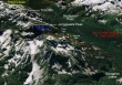
A google earth look at the approximate cross country portion of our trip to Mac Peak... note that while this image shows a lot of snow, there was virtually no snow on our trip.
|
Find the trailhead by driving east from Skykomish for 1.2 miles on Hwy 2... turn right on the Foss River Road #68... at 1.2 miles stay to the right... at 2.5 miles continue straight after driving underneath a trestle... at 3.6 miles turn left and head uphill on FS 6830... continue 6.5 miles and stay left at the junction for the Tonga Ridge trail... now heading downhill, continue ~10.5 more miles to the trailhead for the Deception Creek Cutoff (3640').
|
The sign for the Deception Creek Cutoff trail is not doing so well.
|

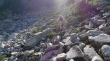
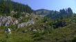
Nice mushroom as we hike downhill toward Deception Creek.
|
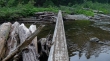
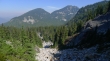
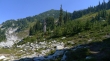
Crossing Deception Creek (3200') after hiking a half-mile... a bit disconcerting having to hike downhill at the beginning of the hike... knowing that it would be an uphill hike at the end of the day.
|
We have reached the PCT (5040')... and will head south toward Snoqualmie Pass on the trail for about 30 steps... then head cross country at a boulder field.
|
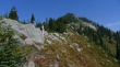
The boulder field where we left the PCT.
|
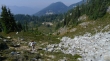
BarbE leading the way... she did this hike last year and did a good job in finding the way.
|
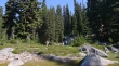
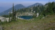
We can see Tarn #1 (5280')... watch for the faint path to the right before reaching the tarn.
|
We lost the faint path at Tarn #1 and headed up a gully.
|
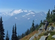
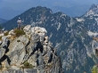
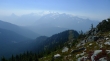
Looking across to Surprise Mountain (left), Surprise Gap and Point 6594... there is smoke in the air from the fires in Eastern Washington.
|
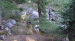
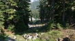
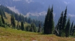
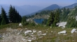
Tarn #2 (5720') is barely surviving... from here the terrain becomes more open.
|
From Tarn #2 we get a good look at the gully that will lead up and and left to the SW ridge of Mac Peak.
|
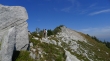
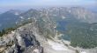
A good look at the Mac Peak summit.
|
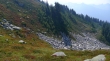
Hiking above Tarn #3 (6040') and heading for the SW ridge of Mac Peak... Spark Plug Mtn is behind Surprise Mtn on the left, Surprise Gap and Point 6594.
|
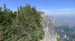
ragman on Mac's SW ridge now... Mt. Daniel across the valley in the smoky haze.
|
BarbE on the SW ridge of Mac Peak.
|
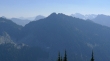
Looking down on Talus Lake which is between Mac Peak and Junggeselle Peak.
|
Looking south to Junggeselle Peak in the haze... we can just barely see Mt. Stuart in the distance to the left of Junggeselle.
|
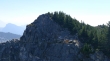
BarbE nearing the Mac Peak summit.
|
BarbE on the Mac Peak summit (6859')... Thor Peak just to the right of the summit in the distance.
|
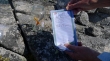
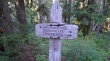
The summit register placed by Eric Willhite a few days earlier... we could not find the nwhiker traveling register or Fay Pullen's register.
|
I'm looking back at BarbE on the true summit from a high point just north of the summit.
|
BarbE got this shot of me on the high point just north of the summit.
|
Looking down on an unnamed tarn (bottom), Square Lake (looks like a figure 8) and Lake Wolverine (above and right of Square)... Spark Plug Mtn and Surprise Mtn are on the left... then Surprise Gap... with Point 6594 to the right of the gap... with Thunder Mountain just right of Point 6594... Thor Peak on the far right.
|
Looking across the valley to Mt. Daniel and Mt. Hinman... the SW ridge (our route to the summit) of Mac Peak is in the foreground.
|
Heading down now... looking at Deception Lakes.
|
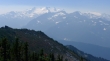
Mt. Daniel and Mt. Hinman in the haze... and looking across Deception Pass to Cathedral Rock on the far left.
|
Looking down on Tarn #3 as we descend.
|
There is a faint path going left-to-right through the center of the photo... we missed it on the way up, but it was much easier to see on the way down.
|
Heading down to Tarn #2.
|

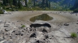
You can barely see Daisy Lake below... we got off route when we left Tarn #1 and ended up at the lake.
|
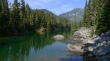
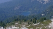
At Daisy Lake which is the first lake you come to before reaching Deception Lakes... leaving a very short hike on the PCT to get back to where we will head down to Deception Creek and the 450 feet of elevation gain back up to the car... a long day.
|
