Mount Si - 11.27.2012
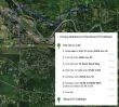
Directions to the Mount Si Trailhead... assumes you are driving east from Seattle on I-90.
|
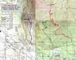
A topo map of the area... the red line is the main trail... 8 miles roundtrip, gaining 3400 feet of elevation.
|

The parking lot (~600') is huge for this very popular trail... room for more than 100 cars.
|
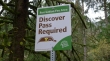
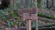
Your will need a valid Discover Pass to park at the Mount Si trailhead.
|
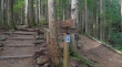
This trail is part of the Mountains to Sound Greenway.
|
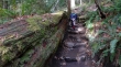
The trail is well maintained.
|
After hiking .7 miles you can take the Talus Loop Trail but it will add an additional third of a mile to your hike.
|

Did I mention that this trail is well maintained?
|
After hiking 1.7 miles the Talus Loop Trail rejoins the Mount Si Trail.
|

This photo shows the attention that a lot of the switchbacks have received from trail crews.
|

Denali Girl out of the trees at ~3800 feet... Mount Rainier in the distance.
|
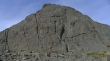
The summit of Mount Si is at the top of The Haystack... most people skip the Class 3 climbing required to go to the top... the trail will take you around to the right for the easier terrain.
|
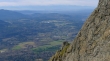
From the base of the Haystack we are looking down on North Bend... and across Puget Sound to the Olympic Mountains.
|

Denali Girl on one of the rock outcroppings on the south side of the Haystack... Rattlesnake Ridge on the left.
|

Mount Rainier and Rattlesnake Lake from our high point.
|
